
Storeggpass
| Storeggpass | |||
|---|---|---|---|
 Nidwalden side |
|||
| Compass direction | west | east | |
| Pass height | 1742 m above sea level M. | ||
| Canton | Obwalden , Switzerland | Nidwalden , Switzerland | |
| Watershed | Big Melchaa | Engelberger Aa | |
| Map (Obwalden) | |||
|
|||
| Coordinates | 667 872 / 188559 | ||

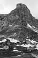
The 1742 m above sea level. M. high Storeggpass is a mountain pass between the Swiss cantons of Nidwalden and Obwalden . It connects the Engelberger Aa valley with the Melchtal . Within the ridge that separates the two valleys, it offers a gap between the Storegghorn and the Widderfeldstock .
A hike from Engelberg leads from the east on a somewhat exposed path high above the Aaschlucht over to the Lutersee and from there on to the pass. Another possibility leads from the lower Engelberg valley, where you can take the small Rugisbalm cable car up to 1400 m to Alp Eggen . On the Obwalden side in the west, various winding paths lead across the Alps and through forest areas down to the village of Melchtal. From the Rütialp until 2005 it was also possible to use the cable car on this side.
Hollow

Lutersee

