
Alpine floods in 2005
| Alpine flood 2005 Deep Norbert |
|
|---|---|
 |
|
| storm | Heavy rain |
| General weather situation | Vb |
| Data | |
| education | August 19, 2005 (Normandy) |
| resolution | August 24, 2005 (Northern Hungary) |
| Rainfall intensity | > 20 mm / h (Western Austria) |
| Rainfall 48 hours | 286.3 mm [l / m] ( Mindelheimer Cottage , 21-23rd, 8 CEST ) |
| Annuality d. High water HQ | > 5000 ( Trisanna / Galtür , Sanna / Landeck) |
| consequences | |
| affected areas | Germany , Austria , Switzerland , Poland , Czech Republic , Slovakia , Hungary , Slovenia , Croatia , Serbia , Romania , Moldova , Bulgaria |
| Victim | > 30 deaths |
| Damage amount | > 3 billion euros |
A strong low over the Adriatic (Tief Norbert , a Vb weather situation ) led large amounts of water over the Balkans , Austria and southern Germany to the Alps between August 20 and 23, 2005 , where the clouds discharged as heavy rain, which led to Alpine floods 2005 in the northern foothills and central Alps . In addition to the disasters in the Alps, the lower Danube region was also affected by the depression, in particular Romania and Bulgaria , where large areas of land were flooded six times by September 2005 ( Danube floods in August 2005 ).
Course of the event
Alpine region
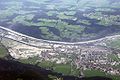
The area affected by the flood catastrophe extended (staggered in time) from Eastern Austria ( Lower Austria , Styria and Carinthia ), through the Central and Eastern Alps ( Bernese Oberland through Central Switzerland , Graubünden , Tyrol and Vorarlberg ) to the Alpine foothills to Bavaria and further the Danube down.
While landslides in particular shaped the damage pattern in the mountain regions and cut off entire villages from the outside world, the problem in the flatter areas was the overflowing rivers and lakes . This completely paralyzed traffic in the affected regions.
Because of the floods, various power plants had to be shut down and power lines switched off for safety reasons, provided they were not affected by the storm. The water supply and disposal also had to be shut down in some regions. The means of communication (landline, cell phone, internet) also failed in the affected areas. Radio amateurs took over the emergency radio traffic and helped to maintain communication.
In Switzerland alone, seven to ten people died in the event, which was rated as a flood of the century , depending on the source.
Austria
Lower Austria
On the evening of August 21, numerous streams and rivers burst their banks in southern Lower Austria and small mudslides descended. The Neunkirchen district was particularly hard hit , and especially the Edlitz and Wartmannstetten area . A total of 26 fire brigades with 258 men were in action. There were still numerous cellars to pump out in the days that followed. Furthermore, numerous fire brigade operations were reported from the St. Pölten area and in the Waldviertel in the Lainsitz catchment area .
Fears that the Danube would carry an extreme amount of water were not confirmed, as the tidal waves of the flooding Inn and the upper reaches of the Danube arrived with a time delay in both Upper Austria and Lower Austria. In addition, the level of the rivers in Lower Austria had dropped earlier. The first tidal wave (of the Inn) hit on August 24th. Since then the level has risen only slowly. Nevertheless, the Danube overflowed its banks in various places, as the amount of water corresponded to a three-year flood. From August 25, the level of the Danube fell continuously.
Styria
In Styria , the provincial capital Graz was particularly affected on August 21, as was the Deutschlandsberg district . In Graz itself, the disaster was pronounced on August 21, after all six brooks overflowed their banks. The southern runway was interrupted by a mudslide near Mixnitz . The Leibnitz district was affected when the Mur overflowed its banks. There was one fatality after a mudslide literally tore away a house.
Vorarlberg
While the situation in Styria calmed down, in Vorarlberg in the regions Bregenzerwald , Arlberg , Montafon and Kleinwalsertal as well as in the riverside areas of the Rhine valley otherwise small streams turned into raging white water.
Mudslides in the Arlberg area destroyed important power lines that paralyzed the entire power network of the Austrian Federal Railways , so that train traffic throughout the country had to be stopped. In Ludesch between Bludenz and Feldkirch, a freight train with a tanker derailed. After a short period of concern, it was announced that the tankers had non-hazardous cargo.
Vorarlberg could not be reached from the neighboring state of Tyrol for several days because all road and rail connections were cut off by mudslides. On August 29, a provisional replacement rail service was set up between Bludenz and Landeck . Regular train operations on the Arlbergbahn could only be resumed on December 3, 2005. The Montafonerbahn was also interrupted for a few days.
The main telephone connection between Vorarlberg and Tyrol and thus between Vorarlberg and the rest of Austria also collapsed. Countless fiber optic and copper lines were completely destroyed over a length of several kilometers after mudslides. The result was that, in addition to landline communication, mobile communication and the Internet in Vorarlberg were also severely affected. However, Telekom Austria and the armed forces were able to rectify the disruptions within two days, or to switch alternative circuits abroad or via satellite.
Several villages ( Gargellen , Bizau , Lech ) were cut off from the outside world, and a total of around 400 people were evacuated on August 22nd.
A total of 3,300 firefighters were on duty in Vorarlberg alone . The drinking water supply in the communities of Bezau , Mittelberg and Lech collapsed, and in Lech there was no longer any electricity supply. In Reuthe , water entering a residential building triggered a chain reaction that led to an explosion. Six people were injured, some seriously.
The mountain pastures , which were cut off from the environment, posed a further problem , as many goods roads slipped or were buried. The animals had to be supplied with food by means of an airlift.
Tyrol
The Inn in Tyrol reached a dangerous high on August 22nd and threatened to overflow in Innsbruck . All of the city’s Inn bridges were closed, and several buildings at the University of Innsbruck had to be cleared.
In the Reutte district , the Lech overflowed its banks, and several villages could not be reached due to flooded roads.
The situation in the Kufstein district came to a head on the afternoon of August 22nd. In the villages of Wörgl and Langkampfen , some of the population was evacuated. The Inntal motorway was also affected, where a bridge threatened to be torn away by being washed away.

Roadblock in the Paznaun Valley

The Paznaun is cut off.

An airlift into Paznaun is set up, here an Alouette III of the armed forces
Flood in the Inn Valley near Wörgl
The western Wörgl one day after the peak of the flood

Concrete mixer truck, spilled in Paznaun, almost 2 months after the flood

Temporary lane in the collapsed gallery near Ischgl


The Paznaun Valley in the Landeck district was hardest hit . 30 percent of the roads in the area have been buried or destroyed. Numerous houses were destroyed in the communities of Ischgl , See and Kappl . In the parish of Pfunds , too , a brook burst its banks and flooded parts of the village. Minor damage occurred in Pians , Mils near Imst and Landeck . On August 26, it was only possible to make an exit of the stuck holidaymakers from the Paznaun Valley via a forest road, after it could only be reached via an airlift of the armed forces . Since a slope was found above the gallery (half tunnel) at the valley exit, the valley exit was closed again due to an impending landslide. On September 1st, the road towards the Silvretta -Hochalpen-Pass was opened. However, it is unsuitable for normal cars. In many places, the destroyed roadway was makeshift repairs using rock and gravel. Driving there was only possible without damage with vehicles with large ground clearance. On September 12, the road to Paznaun was reopened, at least for a time, with one lane.
The clean-up work was marked by strong solidarity. Holiday guests lend a hand, as well as hundreds of voluntary helpers from the unaffected areas of Austria and also from South Tyrol .
Only in December 2005 could the Arlbergbahn be put back into operation due to the severe damage.
Salzburg, Upper Austria
The state of Salzburg was particularly affected on August 23, but the extent was not as high as the floods of 11/12. July 2005 approached, which had caused severe damage in Oberpinzgau . Upper Austria was also relatively little affected.
Switzerland
Central Switzerland
The first reports of accidents of this flood came from Central Switzerland , where various landslides fell in Entlebuch and thus buried traffic routes. Various rivers in the region, such as the Kleine Emme and lakes such as the Sarnersee and the Vierwaldstättersee , flooded their banks, which in turn flooded the towns of Lucerne and Brunnen . The level of Lake Lucerne reached a value which was 2 meters above normal. Well was temporarily cut off from the outside world because the Muota was extremely flood. The measuring station in Brunnen recorded a 21-fold volume of water compared to the normal value. The Reuss weir in Lucerne was destroyed, the one in Perlen-Buchrain threatened to break because of the driftwood.
A landslide between Brunnen SZ and Sisikon led to the total failure of the Gotthard Railway and Axenstrasse . The municipality of Ingenbohl gave its students just one additional week of summer vacation because of the flooded village center .
The entrance to Engelberg was torn away by the mud. The village could only be reached by helicopter. The train connection had to be suspended until the inauguration of a newly built bridge on December 18 .
A siren alarm was triggered in the entire Engelberger Aa valley because of a feared dam breach near Engelberg.
Particularly tragic was the death of two firefighters in Entlebuch , who tried to secure a house from the water on Monday, August 22, 2005, when suddenly a landslide from the forest hit the house.
The floods in the canton of Uri disrupted transport links across the Alps. Both the motorway and the railway line had to be closed for transalpine transit. On August 25th, local trains could run again to a limited extent, and on August 26th an hourly train was again running between Basel and Chiasso .
Bernese Oberland


Various roads and railway lines in the Bernese Oberland were washed under or even washed away by landslides , so that many localities were cut off from the environment. These water masses then caused the lakes to swell. The Lake Thun exceeded the damage limit by almost a meter. This put Interlaken and the traffic routes between Lake Brienz and Lake Thun in particular under water.
In Brienz (see picture) an entire part of the village was destroyed by the torrents, whereby two women were killed. Entire districts had to be evacuated, especially the area between the Trachtbach and Glyssibach. The Birgli retirement home was also evacuated as a precaution. The passage through the village was blocked for two weeks for security reasons.
In Reichenbach im Kandertal , the Kiene brook flooded and damaged around 100 houses in the Kien district. Around 300 residents had to be evacuated; the first people were able to return on Friday, August 26, 2005.
In Oey- Diemtigen , Simmental , the Chirel brook raged , over 200 residents had to be evacuated. The station and the tracks of the BLS Lötschbergbahn ( Spiez - Zweisimmen ) were completely destroyed.
In Guttannen , after the heavy rains, a series of debris flows occurred, which overran the canton road and diverted the Aare so that it flowed through the village. With more than 500,000 m³ of rubble mobilized, this was the largest such event in the Swiss-Alpine region in recent times.
Rest of the canton of Bern
The Aare then pumped four times the normal amount through its river bed. In the city of Bern, this continued the Matte Quarter z. T. several meters under water. On August 24th, the quarter had to be evacuated because the houses were at risk of collapse. Further down the Aare, other towns were flooded.
The Lake Biel has exceeded the damage border on August 22 and flooded several towns along the lake. In addition, huge amounts of driftwood (see picture) were washed into the lake. A total of 7,000–8,000 m 3 of wood had to be removed from Lake Biel alone .
Aargau
In addition to mud and water, the water of the Emme in the canton of Aargau also carried a lot of debris and driftwood with it and then turned the Reuss into a torrent . As a result, many wooden bridges were damaged or even torn. Although some of the debris and driftwood could be held back in the barrages of the Reuss, the villages of Bremgarten AG and Windisch AG in particular were flooded.
Zurich


There were only minor floods in Zurich . But the critically high water level led to the closure of numerous riverside paths.
Walensee region
The road to Elm was buried and the Lint plain was flooded. The autobahn tunnel on Lake Walen carried so much water that the cars were diverted over the Kerenzerberg . The tunnel was still passable for trucks.
Also Weesen was flooded.
Since the Ziegelbrücke train station was also under water, rail traffic between Zurich and Chur and in the direction of Glarus had to be interrupted.
Northeast Switzerland
The Eastern Switzerland was largely spared by the tsunami. The focus was on pumping out basements. The Thur as well as the Sitter stepped over their banks at certain points. In the St. Gallen Rhine Valley , the Rhine carried very large amounts of water, but the pre-dams could hold the additional water and did not exceed the critical limit.
Grisons
The Landquart in the Prättigau led from Vereina , and also from Sardascatal also produces much sediment and driftwood with and flooded large parts of the monastery . The newly built pool was completely destroyed and covered with debris. The Doggiloch and Brügga quarters as well as the retirement home and the playground were completely flooded. The retirement home was evacuated and the residents were quartered in a hotel. In Monbiel , a fraction of the monastery, the slack has been washed away about 50 meters into the country. Several thousand cubic meters of soil have been lost. During the inundation it was unusual for Klosters to be totally inundated. Although the area is steep, the water was up to 3 meters high in some places. Serneus was almost completely cut off from the environment because the bridge to Serneus, which had long been in need of renovation, was swept away by the Landquart. In Küblis , further down in the Prättigau, a walker was torn away by the masses of water, probably from the branches of a tree protruding from the water. The woman was found a few days later on the German shore of Lake Constance . At Fideris , the narrowest part of the valley, the Landquart came threateningly close to the embankment, which led to the closure of the Landquart GR - Davos railway line .
In the Lower Engadine , in Susch , a scree avalanche carried by the Susasca brook thundered through the middle of the village and flooded the village. The bridge of the cantonal road over the stream was largely destroyed and the railway bridge slightly above it was badly damaged.
At the portal of the Vereina tunnel near Sagliains , the road was covered with debris and the valley road was partially washed away. Further in the direction of Guarda , several cubic meters of water, wood and rubble thundered from the Val-Tuoi in the direction of the Inn. The Talbach even washed over the 10 meter high road bridge.
In the vicinity of Scuol the water masses caused some serious damage to roads and railway lines: the railway line between Ardez and Scuol-Tarasp was interrupted by the destruction of the Tasna bridge. In the lower area of the Val Tasna , the canton road was also badly damaged.
The destruction meant that the communities between Susch and Ftan were cut off from the outside world. The situation only improved on Thursday afternoon when the road between Ftan and Ardez was reopened.
Germany
In Germany, southern Bavaria was particularly affected, along with northern Bavaria, the Ore Mountains, parts of North Rhine-Westphalia and the Black Forest.
District of Neu-Ulm

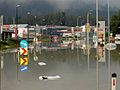
Due to the flooding of the Iller, which flows into the Danube near Neu-Ulm in the Neu-Ulm district , Neu-Ulm was also threatened with a flood disaster. Already on August 23, the disaster alarm was raised and the hospital evacuated. The residential areas directly adjacent to the Danube, such as the residential area or the city center, were successfully protected from the water with the help of large sandbag barriers. The well-known Atlantis leisure pool including the ice skating facility could not be saved and was flooded. In sending had to neighborhoods to be evacuated. The B 28 was also blocked at the level of the B 30 overpass. Contrary to the forecast, the highest level of the Iller near Wiblingen on August 24th at noon remained below the level of the Whitsun flood in 1999 .
Ulm was largely spared. However, the houses in the fishing district adjoining the city wall had to report water in cellars and gardens from the back-dammed blue that flows into the Danube there. The Danube meadow was also completely flooded.
Kempten and the Oberallgäu district
In the Oberallgäu district , the Iller reached all-time highs. When a dam broke in Sonthofen , a campsite was flooded. Caravans were swept away. In Kempten the river Iller threatened to overflow over the flood protection walls. 200 Bundeswehr soldiers were deployed here for flood protection work. Nevertheless, the cemetery and the crematorium, among other things, were flooded.
The federal road and the rail connection to Oberstdorf were interrupted. Furthermore, the B 16 near Füssen and the A 7 in the border tunnel had to be closed. The Tannheimer Tal was cut off from the outside world by mudslides. Important pass roads into neighboring Tyrol, such as the Fernpass and the Arlbergpass , were closed. While most of the road closures were only temporary, access to Birgsau was impossible for days.
Garmisch-Partenkirchen district
In the Garmisch-Partenkirchen district , extensive areas of Eschenlohe were flooded by a dam failure . All access roads to Garmisch-Partenkirchen were briefly interrupted.
Munich

On August 23, the level of the Isar rose to the highest level of the century (Q max ~ 980 m³ / s). A day later the top wave rolled towards Freising . The situation worsened after the Sylvenstein store had to be opened. Several villages in the catchment area of the Isar were flooded.
Fortunately, the dams in the city of Munich were reinforced after the 1999 Whitsun flood . Nevertheless, in some parts of the city, such as the Au, the groundwater pushed upwards, so that several cellars had to be pumped out by the fire brigades and mobile vehicles of the municipal utilities. The Deutsches Museum also reported water ingress.
augsburg

In Augsburg, the provisional foundations of the new construction of the motorway bridge of the federal motorway 8 over the Lech (1540 m³ / s) were washed away, and on the morning of 23 August the bridge, which had not yet been completed, sagged by about 30 cm on the east side. As a precaution, the motorway bridge behind it was also closed. In addition, the population in some areas has been prepared for evacuation because of the risk of backwater in the event of a collapse. Tram traffic on line 1 to and from Lechhausen was also discontinued and other Lech bridges were prepared for closure.
After the foundation could be stabilized in the course of the day with the help of a lot of truckloads of large stones, the full closure of the bridge was lifted again on the night of August 24th. According to experts, the incident was supposed to delay the completion of the new bridge by at least six months, but the damage amounting to around 2 million euros was already repaired in December.
Furthermore, the temporary structure of the diesel bridge threatened to be swept away by the flood of the Wertach. The bridge therefore had to be closed as well. This in turn led to traffic chaos in Augsburg and Gersthofen , with the result that a backlog of 20 km and 15 km respectively formed on the A 8 motorway.
Lower Danube Region
In addition to the rapid emergencies in the Alpine region, the lower Danube region was particularly affected. Enormous precipitation fell directly here, which after the series of floods in 2005 led to extensive flooding, on which the tidal mountains of the Alpine floods accumulated over the course of several days.
Number of victims and extent of damage
The flood is believed to have killed at least 30 people, 23 in Bulgaria, 6–10 in Switzerland and 1 in Austria. The number of evacuees in the lower Danube region went into the ten thousand.
The total losses in Switzerland, Austria, Germany, Hungary and Slovenia alone are estimated by the Munich Reinsurance Company at 2.7 billion euros, the majority of which is attributable to Switzerland. The extent of the damage in Romania and Bulgaria is said to amount to around 1 billion euros, although the damage from the various floods can hardly be separated: the USDA already estimated harvest losses of 19% in the Balkans for July .
Switzerland
A statement from October 27, 2005 showed that in Switzerland alone the damage amounted to 2.5 billion francs , of which around 550 million related to the public sector (roads, bridges, streams). For effective flood protection, a total of 600 million more will have to be spent over the next few years.
Since the floods were accompanied by power outages in many places , it was found that large parts of the population alarmed by sirens were unable to obtain information via radio , as battery-operated radios in households continue to decline in favor of stereo systems . The Swiss Federal Office for Civil Protection therefore began to develop new information concepts.
Austria
In Tyrol, the amount of damage (partly including the July floods) is estimated at around 260 million euros , in Vorarlberg at 180 million, in Styria at 60 million euros and in the province of Salzburg at around 60 million, so that the total damage in Austria is clear should be over 500 million euros. Both forces of the armed forces and the disaster relief service of the fire brigades of other federal states were deployed to provide support.
Sometimes houses can no longer be built at their current locations. The railway line over the Arlberg was not passable until December 2005.
On September 7, 2005, the final gala organized by ORF in the Innsbruck ice rink took place for the flood victims with 7,000 visitors (with stars such as DJ Ötzi , Hansi Hinterseer and the Kastelruther Spatzen ). More than 1,750,000 euros were donated to the flood victims during this campaign.
See also
literature
- Event analysis flood 2005 . In: Federal Office for the Environment FOEN (Ed.): Documentation of events . ( Event analysis flood 2005 ( Memento from May 31, 2012 in the Internet Archive ) Index to web documents - Switzerland).
- Reinhold Godina, Petra Lalk, Peter Lorenz, Gabriele Müller, Viktor Weilguni: The flood in Austria from August 21st to 25th, 2005 - description of the hydrological situation . Ed .: Ministry of Life VII / 3. Vienna 2006 ( PDF 2.1 MB , WASSERnet> The water cycle> Situation reports - partial report of the Hydrographic Service, Austria).
- Helmut Habersack, Gerald Krapesch: Flood 2005 - Event Documentation . Ed .: Ministry of Life . Vienna 2006 ( pdf 5.2 MB , WASSERnet - nationwide documentation of the Federal Water Management Administration, the Forestry Service for Torrent and Avalanche Control and the Hydrographic Service).
- Nordkette: Case study on the Alpine floods 21. – 23. August 2005 - focus on western Austria . In: Wetterzentrale (ed.): Forum archive . September 28, 2007 ( HTML document - focus on Austria).
- Andreas Wagner, Stefan Laps: Development of the Alpine flood disaster (August 19-25, 2005) . In: Meteomedia (Ed.): Research & Development: Severe weather events . August 2005 ( Development of the Alpine flood catastrophe ( August 19 to 25, 2005) ( Memento of May 11, 2011 in the Internet Archive ) - focus on Germany).
Web links
Individual evidence
- ^ Lit: Nordkette / Wetterzentrale
- ^ Lit: Wagner, Laps / Meteomedia
- ↑ BMLFUW Department VII / 3 Water Management (Ed.): Flood event August 21-25, 2005 in Austria. First assessment of the annual frequency of the flood peaks that have occurred . August 25, 2005 ( pdf 16.5 kB - Lit. FOEN: Event documentation ).
- ↑ a b c d M. Bell, A. Giannini, E. Grover-Kopec, B. Lyon, C. Ropelewski, A. Seth (contributions): August 2005. Climate Impacts - July. Agriculture. Europe - Bulgaria, Romania. In: IRI Climate Digest. The International Research Institute for Climate and Society (IRI), University of Columbia, July 8, 2007, accessed March 23, 2004 .
- ↑ a b Munich Reinsurance Company NatCatSERVICE, quoted. n. Damage from major flood disasters in Central Europe since 1993 (in million euros). Statista, 2009, accessed March 23, 2009 .
- ↑ Information and images of the floods in Graz and Styria ( Memento from May 27, 2007 in the Internet Archive ) - geoWEB-Magazin, Institute for Geography and Spatial Research, Graz
- ↑ Information and pictures of the flood in Vorarlberg (PDF; 3.6 MB) - Office of the Vorarlberg state government - official damage report on the flood in August 2005
- ^ ORF Vorarlberg, August 22, 2008
- ^ Flood 2005 , Disaster Relief in Tyrol, Austria's Armed Forces
- ↑ photos and information on the damage the floods in 2005 in the district of Landeck, especially Paznaun and Arlberg ( Memento of 26 November 2005 at the Internet Archive ), alpinesicherheit.com (Austria)
- ↑ Hydrometeorological aspects of the flood in southern Bavaria in August 2005 , DWD ,
- ↑ Pictures of the floods of the Danube from August 2005 in Ulm and Neu-Ulm ( Memento from June 29, 2009 in the Internet Archive ), ingo-stoeldt.de (Germany)
- ↑ Pictures of the 2005 flood in Eschenlohe , validom.de (Germany)
- ↑ Pictures and information of the flood in Munich , mpics.teamone.de (Germany)
- ↑ as of 2006, after Lit: Haber bag Krapesch / BMLFUW: event documentation . 1.2. Federal hydraulic engineering administration and monetary consideration, p. 2-7 .
- ^ ORF Tirol, August 26, 2008