Lainsitz
| Lainsitz / Lužnice (Luschnitz) | ||
|
Course and catchment area |
||
| Data | ||
| location | Austria and the Czech Republic | |
| River system | Elbe | |
| Drain over | Vltava → Elbe → North Sea | |
| source | At Karlstift in the Waldviertel in Austria, 48 ° 35 '44 " N , 14 ° 44' 14" E |
|
| Source height | 980 m above sea level A. | |
| muzzle | In the Vltava near Neznašov Coordinates: 49 ° 13 '50 " N , 14 ° 23' 22" E 49 ° 13 '50 " N , 14 ° 23' 22" E |
|
| Mouth height | 350 m nm | |
| Height difference | 630 m | |
| Bottom slope | 3 ‰ | |
| length | 208 km | |
| Catchment area | 4,226.2 km² | |
| Drain |
MQ |
24.3 m³ / s |
| Right tributaries | Braunaubach , Reissbach , Neumühlbach , Nežárka , Smutná | |
| Medium-sized cities | Tábor | |
| Small towns | Weitra , Gmünd , České Velenice , Suchdol nad Lužnicí , Veselí nad Lužnicí , Soběslav , Planá nad Lužnicí , Sezimovo Ústí , Bechyně | |
|
The Lainsitz on the Czech side near Suchdol nad Lužnicí |
||
The Lainsitz , in the Czech Republic Lužnice , is a tributary of the Vltava in Austria and the Czech Republic . The total length is around 200 kilometers, 43 of which are in Austria. The German name in Bohemia was not Lainsitz, but Luschnitz . Along with the Maltsch in Upper Austria, with its tributaries, it is a river system in Austria (except for Vorarlberg) that drains to the North Sea and not to the Danube .
course
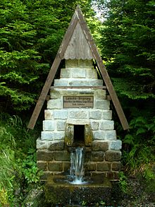
The Lainsitz rises in the Freiwald am Aichelberg near Karlstift in the Waldviertel at 980 m above sea level. A. After two kilometers, it changes to Czech territory at Pohoří na Šumavě ( Buchers ) and flows north along the border. At Joachimstal , a part of the municipality of St. Martin , she comes back to Austria. It flows around the Wachberg , reaches the town of Weitra , from Altweitra its gradient becomes smaller. In the city of Gmünd it briefly becomes a border river again, at Breitensee it finally changes to the Czech Republic. It and its tributary, the Braunaubach von Schrems, mark the European main watershed in the granite and gneiss plateau . To the southeast of this valley, the Danube basin drains deep into the Balkans to the Black Sea .
The next 100 kilometers to Planá nad Lužnicí it struggles through the Wittingau basin with a total gradient of only 100 meters. Above Majdalena , the Golden Canal is diverted from the Pilař weir . The Lainsitz flows through the largest pond in Central Europe north of Třeboň ( Rosenberger pond , 489 ha ). To protect this pond from floods, the Nová řeka was built, a canal that guides Lainsitz water into the Nežárka .
Then it cuts through the edge of the basin, the Central Bohemian Granite Height, from Tábor to the mouth in a canyon-like valley up to 50 meters deep .
North of Týn nad Vltavou , it flows into the Vltava at about 350 meters above sea level near Neznašov in the Kořensko Dam , a preliminary dam of the Orlík Dam .
The Lainsitz is the most popular river for water tourism in the Czech Republic. At normal water level, it is navigated from Suchdol nad Lužnicí (125 km). The Pilař, Dráchov, Čejnov and Červený mlýn weirs are among the most dangerous in the Czech Republic for water sports enthusiasts due to the strong countercurrent in the underwater.
Tributaries
- Tributaries in Austria are the Braunaubach , in the Czech Republic the Dračice ( Reissbach ) (r), the Koštěnický potok ( Neumühlbach ) (r) near Majdalena , the Nežárka (r) in Veselí nad Lužnicí and the Smutná in Bechyně .
natural reserve
Both in the entire course of the river in Austrian territory through the Waldviertel and in the further course through the Wittingau Basin , the Lainsitz is an area according to the Ramsar Convention with the names Waldviertel pond, moor and river landscape , pond area Trebon and moor area Trebon .
literature
- Herbert Knittler, Andrea Komlosy (Ed.): The Lainsitz. Natural and cultural history of a region . St. Pölten, 1997.
Web links
Individual evidence
- ↑ Nebezpečné jezy
- ↑ Waldviertel pond, moor and river landscape on the website of the Federal Ministry of Agriculture and Forestry from October 18, 2010, accessed on February 25, 2012


