Smutná
|
Smutná Smutna / Cedron |
||
|
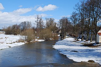
Smutná near Rataje |
||
| Data | ||
| Water code | CZ : 1-07-04-093 | |
| location | Jihočeský kraj , Czech Republic | |
| River system | Elbe | |
| Drain over | Lainsitz → Moldau → Elbe → North Sea | |
| source | Stružinec north of 49 ° 31 '10 " N , 14 ° 32' 29" O |
|
| Source height | 620 m | |
| muzzle | at Bechyně Castle in Lainsitz Coordinates: 49 ° 17 ′ 21 ″ N , 14 ° 28 ′ 8 ″ E 49 ° 17 ′ 21 ″ N , 14 ° 28 ′ 8 ″ E |
|
| Mouth height | 356 m | |
| Height difference | 264 m | |
| Bottom slope | 5.5 ‰ | |
| length | 47.8 km | |
| Catchment area | 247.01 km² | |
| Discharge at the Rataje gauge |
MQ |
1.01 m³ / s |
| Flowing lakes | Velká Kaplice, Chobot | |
| Small towns | Bechyně | |
The Smutná (German Smutna ), on the upper reaches of Cedron , is a right tributary of the Lainsitz in the Czech Republic .
course
The Cedron rises north of the village of Stružinec in the Central Bohemian Hills ( Středočeská pahorkatina ). On its upper course leading to the southwest, past Nehonín and U Kaplice, the brook is dammed in the ponds Černý rybník, Nehonínský rybník, Velká Kaplice, Nový rybník and Obecní rybník. In Jistebnice the Cedron turns to the west, along its course are Zvěstonín, Pohoří, Zbelítov, Hodkov, Slabov, Petříkovice, Kotaškov and Hronova Vesec. From the mouth of the Nadějkovský potok the brook is called Smutná and flows past Vozdrakov, Hromadov, Modlíkov, Micáskův Mlýn, Vratišov, Prachárna, Cmuntov, Vlksice and Dolejší Mlýn to the southwest. The rest of the run goes through Duškanka, Božetice , Kvěchov, Vlkovina, V Chlumu, Chobot, U Vyhnalů, Závist, U Krajíců, Hanov, Srlín, Kozín, Rataje , Haškovcova Lhota , U Viktorů, Radětice , Na Prádle, Pichamelnoušť, Cihamelnouš, and to the south. On the western outskirts of Bechyně the Smutná forms a deeply cut valley with several river loops. After 47.8 kilometers the Smutná flows into the Lainsitz at the foot of the Bechyně Castle .
At Kvěchov the Smutná is bridged by the Tábor – Písek railway. East of Sepekov , the river is dammed below the remains of the Skalice castle in the Chobot pond.
Smutný natural monument
The section of the river below the Chobot dam has been protected as a Smutný natural monument since 1985 over a length of two and a half kilometers to the road bridge between Sepekov - Opařany. The 4.35 hectare reserve includes natural meanders through alluvial forest.
Flood in 2002
During the flood of the century in 2002, the Mlýnský rybník dam in Nadějkov broke on the night of August 6th and 7th . On August 8, the Smutná in Rataje reached a water level of 3.10 m and flooded parts of Rataje and the Bechyněr district of Plechamr. Between August 12 and 16, the Cedron flooded parts of Jistebnice.
Tributaries
- Chlumský potok (r), U Kaplice
- Křivošínský potok (l), Jistebnice
- Plechovský potok (r), Zvěstonín
- Petříkovický potok (r), near Petříkovice
- Nadějkovský potok (r), near Hronova Vesec
- Kvaštovský potok (r), near Vlksice
- Dobřemilický potok (r), Dolejší Mlýn
- Radihošťský potok (l), Duškanka
- Božejovický potok (l), Božetice
- Božetický potok (l), below Božetice
- Milevský potok (r), U Krajíců
- Cabrovský potok (r), Hanov
- Karlov (l), near Opařany
- Kolišovský potok (r), Srlín
- Hemera (r), U Viktorů
- Plzinský potok (r), Cihelna

