
Opařany
| Opařany | |||||
|---|---|---|---|---|---|
|
|||||
| Basic data | |||||
| State : |
|
||||
| Region : | Jihočeský kraj | ||||
| District : | Tábor | ||||
| Area : | 3143 ha | ||||
| Geographic location : | 49 ° 24 ' N , 14 ° 29' E | ||||
| Height: | 464 m nm | ||||
| Residents : | 1,399 (Jan. 1, 2019) | ||||
| Postal code : | 391 54 - 391 61 | ||||
| License plate : | C. | ||||
| traffic | |||||
| Street: | Tábor - Písek | ||||
| Next international airport : | České Budějovice Airport | ||||
| structure | |||||
| Status: | local community | ||||
| Districts: | 7th | ||||
| administration | |||||
| Mayor : | Blanka Řezáčová (as of 2012) | ||||
| Address: | Opařany 30 391 61 Opařany |
||||
| Municipality number: | 552801 | ||||
| Website : | www.oparany.cz | ||||


Opařany , until 1923 Opořany (German Woporschan ) is a municipality in the Czech Republic . It is located 15 kilometers west of Tábor in South Bohemia and belongs to the Okres Tábor .
geography
Opařany is located in the Central Bohemian hill country on a ridge between the Smutná and Oltyňský potok valleys . The state road I / 29 between Tábor and Písek runs through the village . The Srubce (467 m) rises to the southeast, the Noviny (476 m) to the south, the Za Hromadou (450 m) to the west and the Na Hůrkách (473 m) and the Chlum (540 m) to the northwest. At the southwest exit of the village is the Kášovka pond, west of the Tomešín.
Neighboring towns are Vedral, Hodušín, Skrýchov u mastoparan and Nové Dvory in the north, V Sosninách, Sosniny, Oltyně and Kášovice in the Northeast, RePEc , Na Chalupách and Dražičky the east, Bejšovcův Mlyn, Bečice , Hájky and Slavňovice the southeast, Stádlec , Sítiny and Staré Sedlo in the south, Srlín and Popovec in the southwest, Zběšičky and Hanov in the west and Karlov and Podboří in the northwest.
history
Finds of barrows from the Latène period in the forest southwest of the village prove that the area was settled at an early age.
The first written mention took place in 1268, when King Ottokar II. Přemysl the fortress Opařany including the brewery from the Prague bishop Johann III. acquired. From 1375 the villages Opařany (later were lower village ) and Opařanky (later Oberndorf ), which together grew later to the possessions of the diocese and the Church of St. Peter and Paul on Vysehrad . During the Hussite Wars , Opařany initially belonged to Tábor . Later it was pledged by King Sigismund to Ulrich von Rosenberg and Matěj Dubecký von Dubeč. In 1437 the estate returned to the free royal city of Tábor. Because of the participation in the class uprising of 1547, the goods of the town of Tábor were confiscated and Opařany was sold to Veit the Elder in the same year. J. von Zrzawa and Stahletz (Vít ml. Ze Rzavé na Stálci) awarded. In 1593 the lords of Zrzawa sold the estate to Anna von Dlouhá Ves. Her husband Sigmund Chrt von Rtín made Opařany next to Zvoleněves one of his seats. In 1623 Anna Chrtová von Rtín left the estate to the Prague merchant Johann de Vit von Lilienthal, who in 1628 sold it to Anna Haslauer von Haslau , née Kalenická, on Olší. This was convicted in 1647 for cruel torture of subjects. Her daughter left Opařany in 1658 to the widowed Franziska Countess Slawata , born von Meggau (1609–1676), who had been married to Wilhelm Slavata's son Joachim Ulrich († 1645). Their son, the General of the Carmelite Order Johann Karl Joachim, with whom the Slawata family died out in 1712, sold the Opařany estate to the Jesuit College of St. Trinity in Neuhaus . This sold it two years later for 35,000 guilders to the Prague Jesuit College of St. Clement . The Prague Jesuits had already successively acquired the goods Bernartice (1606) and Borovany (1623) as well as the villages Kolíšov (1621) and Bojenice (1624); In 1691 the Dobronice estate was added. The villages of the Opařany estate were Držkrajov, Hanov, Kolíšov, Opařany, Ráb, Podboří, Přeštěnice , Srlín, Skrýchov and Zálší. In 1727 they united the goods to the allodial rule Wopořan and Bernarditz. After the Jesuit ban of 1773, the Clementinum's property was confiscated from the court chamber in favor of the study fund. With that the parish also went out, in 1787 a pastor was again employed in Opařany by the religious fund. The eight manorial farms in Bernartice, Borovany, Dobronice, Kolíšov, Podboří, Podolí, Srlín and Opařany were emphyteutized under the administration of the Imperial and Royal State Property Administration . During this time the castle was used as a training center for preachers and missionaries. In 1825, Quidobaldina Fürstin von Paar , née Cavriani, acquired the rule in the course of a public auction for her son Karl, who linked her with his rule Bechin .
In 1840 the allodial rule covered an area of 12,707 yoke 1092 square fathoms and had 5176 predominantly Bohemian-speaking subjects, including nine Israelite families. Agriculture was the main source of income. The subordinate market of Bernarditz and the villages of Wopořan, Podboř (Podboří) , Hanow (Hanov) , Srlin (Srlín) , Bojenitz (Bojenice) , Borowan , Kollischow (Kolíšov) , Neu-Raab (Ráb) , Podoly , Rakow ( Rakov) , Groß-Zbieschitz (Zběšice) , Dobronitz , Altsattel (Staré Sedlo) , Drschkrajow (Držkrajov) , Unter-Přesstěnitz , Podolsko, Skreychow (Skrýchov) and Zalschy (Zálší) as well as part of the Kaschovice house ( Našetscher Jowitz) Řepečkách) , from Dobřegitz (Dobřejice) the Beyschowetz mill (Bejšovcův Mlýn) , from Malschitz the Markow mill (U Marků) and from Cenkow (Čenkov) the remote Hegerhaus.
The village of Wopořan or Wopařan formed the official village of the Dominium. It was divided into an upper and a lower village and consisted of a total of 92 houses with 728 inhabitants, including two Israelite families. In the village there was the stately two-storey castle in the lower village with apartments for the administrator, the officials and the pastor, as well as the parish church and a school under patronage. There were also two general stores and two inns. The former post office no longer existed at this time. Wopořan was the parish for Podboř, Hanow, Srlin, Repetsch and Kaschowitz. Until the middle of the 19th century, Wopořan was always the official village of the allodial rule Wopořan and Bernaditz.
After the abolition of patrimonial formed Opořany / Wopořan 1850 a municipality in the district administration Milevsko / Mulhouse and the Judicial District Bechyně / Bechin. In 1887 the regional committee bought the castle from Prince Karl Paar and built an asylum in it. In 1890 Opořany consisted of 123 houses in which 1103 Czechs and 45 Germans lived. There was a parish church, a post office, a three-class school and a branch of the royal insane asylum in Prague. With financial support from Karl Franz Bartos Sturz-Sattelberg (Karel František Bartoš Sturc-Sattelberg) , the branch of the state mental hospital was transformed into a clinic for mentally handicapped children in 1923. The current place name Opařany was introduced in 1924. Since the end of 1960 the community has belonged to the Okres Písek . At the same time Podboří was incorporated with Karlov. On July 1, 1980, Skrýchov u Opařan was incorporated with the districts Hodušín, Nové Dvory and Olší. At the same time, Oltyně was spun off from the municipality Řepeč and Opařany was added. On July 6, 1999, a storm with hail the size of a pigeon's egg caused major damage in Opařany.
Community structure
The municipality of Opařany consists of the districts Hodušín (Hoduschin) , Nové Dvory (Neuhof) , Olší (Wolschi) , Oltyně (Woltin) , Opařany (Woporschan) , Podboří (Podborsch) and Skrýchov u Opařan (Skrejchow) as well as the settlement of Karlov.
Attractions
- Baroque pilgrimage church of St. Franz Xaver in Opařany, it was built in 1732–1735 according to plans by Kilian Ignaz Dientzenhofer instead of a chapel; the tower was completed in 1748
- Niche chapel of St. John of Nepomuk next to the church in Opařany, built in the 18th century
- Three-sided wayside shrine, created in 1840
- Memorial stone for those who fell in the First World War in Opařany
- Former Baroque Opařany Castle with a large park, it was built in 1717–1727 as a Jesuit residence, in 1888 it was converted into a madhouse after it was bought by the state. Today it serves as a clinic for child psychiatry and is not accessible
- Church of St. Wenceslas in Hodušín
- Oltyně Castle, neo-renaissance building with English landscape garden
- Attractions

Parish Church of St. Franz Xaver
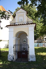
Niche chapel of St. John of Nepomuk

Rear view of the castle
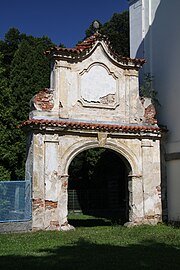
Old portal to the castle grounds


Sons and daughters of the church
- Johann Peisker (1851–1933), historian
Individual evidence
- ↑ Český statistický úřad - The population of the Czech municipalities as of January 1, 2019 (PDF; 0.8 MiB)
- ↑ Johann Gottfried Sommer : The Kingdom of Bohemia. Represented statistically and topographically. Volume 10: Tabor Circle. Ehrlich, Prague 1842, pp. 41–46.
- ↑ Ottův slovník naučný
- ↑ Archived copy ( memento of the original from February 10, 2011 in the Internet Archive ) Info: The archive link was inserted automatically and has not yet been checked. Please check the original and archive link according to the instructions and then remove this notice.