Borkovice
| Borkovice | ||||
|---|---|---|---|---|
|
||||
| Basic data | ||||
| State : |
|
|||
| Region : | Jihočeský kraj | |||
| District : | Tábor | |||
| Area : | 1625 ha | |||
| Geographic location : | 49 ° 12 ' N , 14 ° 39' E | |||
| Height: | 416 m nm | |||
| Residents : | 233 (Jan. 1, 2019) | |||
| Postal code : | 391 91 | |||
| License plate : | C. | |||
| traffic | ||||
| Street: | Veselí nad Lužnicí - Hodětín | |||
| Next international airport : | České Budějovice Airport | |||
| structure | ||||
| Status: | local community | |||
| Districts: | 1 | |||
| administration | ||||
| Mayor : | Jiří Jech (as of 2012) | |||
| Address: | Borkovice 35 391 81 Veselí nad Lužnicí 1 |
|||
| Municipality number: | 552097 | |||
| Website : | www.borkovice.cz | |||
Borkovice (German Borkowitz ) is a municipality in the Czech Republic . It is located five kilometers northwest of Veselí nad Lužnicí in South Bohemia and belongs to the Okres Tábor .
geography
Borkovice is located on the right side of the Brod brook at its confluence with the Blatská stoka in the Soběslavská Blata region in the Wittingau basin . The Panský Kopec (434 m) rises to the southwest. The bog areas Borkovická blata and Kozohlůdky extend to the north.
Neighboring towns are Borkovický Dvůr, Svinky, Vlastiboř , Záluží, Mokrá and Vesce in the north, Čeraz, Soběslav and Dráchov in the Northeast, Řípec and Žíšov the east, Veseli nad Lužnicí in the southeast, Horusice, Kundratice and Sviny in the south, Dolní Bukovsko , Horní Bukovsko and Sobětice in the southwest, Hartmanice and Mažice in the west and Klečaty and Komárov in the northwest.
history
The first written mention of Borkovice took place on April 1, 1354, when Ulrich IV von Neuhaus sold the village along with Zálší , Mažice , Svinky, Vlastiboř and Sviny to the Rosenbergs . Ulrich II von Rosenberg left part of the village to the Augustinian monastery in Wittingau in 1430 . After the abolition of the monastery in 1785, Prince Johann von Schwarzenberg acquired the monastery buildings and the monastery property in 1787, which he attached to his rule in Wittingau. The schoolhouse was built after 1817. The peat extraction in the moors began in the first half of the 19th century; it was done by hand, the cut peat was dried to peat bricks. In 1840 Borkowitz consisted of 52 houses with 317 inhabitants, twelve of which were subordinate to the Zalschy estate. There was a school in the village. A remote hunter's house ( Jitra ) and a meadow keeper's house belonged to Borkowitz . The parish was Drachow . Until the middle of the 19th century, the village was always subject to the Wittingau estate.
After the abolition of patrimonial formed Borkovice / Borkowitz 1850 a municipality in the district administration Trebon / Wittingau and the judicial district Veseli nad Lužnicí . After a new school was built, a poor house was set up in the old schoolhouse in 1897; today it is the seat of the municipal office. During the German occupation between 1943 and 1945 prisoners from the Plan labor education camp worked in the peat cuttings. After the Okres Třeboň was abolished, Borkovice became part of the Okres Soběslav in 1948. Since the middle of the 20th century, peat extraction has been carried out industrially; it was stopped in the late 1970s due to exhaustion of the peat stores. The Okres Soběslav was dissolved again in 1961 and the community assigned to the Okres Tábor. On July 1, 1980, Zálší, Mažice, Klečaty, Sviny and Kundratice were incorporated. After referendums, these villages broke up on November 24, 1990 and formed their own communities.
Community structure
No districts are shown for the municipality of Borkovice. Borkovice to include monolayer Borkovický Dvůr and Jitra.
Attractions
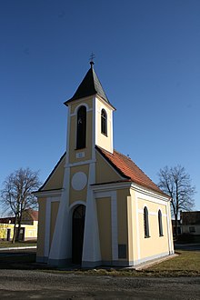
- Chapel, built in 1814
- Several farmsteads in the Blata style of the South Bohemian peasant baroque
- Natural monument Borkovická blata, north of the village, from the Jitra Hegerhaus, a nature trail leads into the peat bog
- Hegerhaus Jitra, Alois Jirásek wrote his novel Proti všem here
- Nature reserve Kozohlůdky peat bog, north of Borkovice
Sons and daughters of the church
- Ladislav Kubeš (1924–1998), composer, arranger and musician
Individual evidence
- ↑ Český statistický úřad - The population of the Czech municipalities as of January 1, 2019 (PDF; 0.8 MiB)
- ↑ Johann Gottfried Sommer : The Kingdom of Bohemia. Represented statistically and topographically. Volume 9: Budweiser Kreis. Ehrlich, Prague 1841, p. 95.


