
Sudoměřice u Bechyně
| Sudoměřice u Bechyně | |||||
|---|---|---|---|---|---|
|
|||||
| Basic data | |||||
| State : |
|
||||
| Region : | Jihočeský kraj | ||||
| District : | Tábor | ||||
| Area : | 2491 ha | ||||
| Geographic location : | 49 ° 17 ' N , 14 ° 32' E | ||||
| Height: | 439 m nm | ||||
| Residents : | 762 (Jan. 1, 2019) | ||||
| Postal code : | 391 72 | ||||
| License plate : | C. | ||||
| traffic | |||||
| Street: |
Bechyně - Soběslav Tábor - Hodětín |
||||
| Railway connection: | Tábor – Bechyně | ||||
| Next international airport : | České Budějovice Airport | ||||
| structure | |||||
| Status: | local community | ||||
| Districts: | 3 | ||||
| administration | |||||
| Mayor : | Stanislav Houdek (as of 2012) | ||||
| Address: | Sudoměřice u Bechyně 105 391 72 Sudoměřice u Bechyně |
||||
| Municipality number: | 553166 | ||||
| Website : | www.sudomerice.cz | ||||


Sudoměřice u Bechyně (German Sudomierschitz ) is a municipality in the Czech Republic . It is located five kilometers east of Bechyně in South Bohemia and belongs to the Okres Tábor .
geography
Sudoměřice u Bechyně is located in the southern part of the Bechyn Hills ( Bechyňská pahorkatina ). To the south-west rises on the site of the military airfield Bechyně of Soudný (456 m). The Černická obora nature park extends to the east. The Tábor – Bechyně railway line runs on the northern outskirts , and the connecting railway to the military airfield runs south.
Neighboring towns are Cernysovice and Bechyňská Smoleč in the north, Dudov, Marunka and Vyhnanice in the Northeast, Hlavatce , Černice, Na Brane and Debrník the east, Svinky, Vlastiboř , Komárovská Hajnice, Benešovská Hajnice and Komárov in the southeast, Nová Ves, Hodětín , Německý Dvůr and Jamník in the south, Hodonice and Nuzice in the south-west, Pouzarovna, Kopaniny, Radostná, Kamenný Dvůr, Chrobkov and Bechyně in the west and Sádky, Bežerovice and Hutě in the north-west.
history
The first written mention of the village Sudymierzice belonging to the rule Bechin took place in 1352 in a papal tithe register . At that time the owners were the Lords von Sternberg . There is evidence of a parish church in Sudymierzice from 1384 and 1409. The parish probably went out during the Hussite Wars , after which the All Saints Church became a branch church of the Bechin parish. The village of Černičky to the east fell into desolation in the 15th century and was not repopulated. Between 1441 and 1477 the rule belonged to the Bechinie von Lazan , then again to the lords of Sternberg. In 1514 Ladislav von Sternberg began with the approval of King Vladislav II Jagiello with the dismantling of several hematite deposits. An iron hammer was built on the Lainsitz for processing . After it had been shown that the individual hematite deposits did not form a large deposit and were soon dismantled, ore was brought in from Kamenice nad Lipou for the operation of the iron hammer . In 1530 the Lords of Schwanberg bought Bechyně, in 1569 Heinrich von Schwanberg sold the rule to Peter Wok von Rosenberg . The abundant springs in the vicinity of Sudoměřice prompted Peter Wok in 1586 to have master Řehoř Koráb build a wooden pipe for the drinking water supply of his Bechin Castle residence . Emperor Rudolf II granted Peter Wok the privilege to collect a toll at the crossroads of two trade routes between Bechin and Sobieslau and between Tabor and Budweis near Sudoměřice. In 1586 Peter Wok had a large zoo with an area of 4,500 hectares around the extinct village of Černičky. A 20 kilometer long fence with three gates prevented the game from running away. The zoo was later reduced to 2,060 hectares. In 1589 the entire village burned down. At the beginning of the Thirty Years War, the village was located in the area left of the Lainsitz, which was most severely devastated, and was destroyed in 1619. In 1636 Sudoměřice was described in the Bechiner land registers as completely burned down and desolate. The resettlement was slow, in 1688 there were 21 chalets in Sudoměřice instead of the previous farms . A school was set up around 1700, classes initially took place in various private houses, and later a small schoolhouse was built. In 1715 the Counts of Paar acquired the rule by marriage. In 1787 a parish was set up again in Sudoměřice from funds from the Religious Fund. In 1793 Prince Paar had a baroque hunting lodge built in the zoo on the Černičky desert.
In 1840 the village Sudoměřitz / Sudoměřice on the road from Tabor to Moldau-Thein consisted of 46 houses with 359 inhabitants, including three Israelite families. In the village there was an inn, the parish church and parish, which were under the patronage of the religious fund, and a school under the patronage of the manor. The hunting lodge Černitz or Černicky with a forester's lodge was surrounded by a large, restricted zoo with red and wild boar. In addition, there were the single-layer Heger houses Marunky and Thorheger as well as a hunter's house in the zoo . Sudoměřitz was the parish and school location for Bežerowitz ( Bežerovice ), Blatetz ( Blatec ), Březnitz , Černoschowitz , Eisenhammer , Hodietin , Hodonitz , Neudorf ( Nová Ves ), Smoletsch ( Bechyňská Smoleč ) and Wschechlap ( Všechlapy ). Until the middle of the 19th century Sudoměřice always remained submissive to Bechin .
After the abolition of patrimonial formed Sudoměřice / Sudoměřitz 1850 a municipality in the district administration Milevsko / Mulhouse and the Judicial District Bechyně / Bechin. The old cemetery around the All Saints Church in the center of the village was closed in 1886 because it had become too small for the ten parish villages. A new cemetery was consecrated on the northeast edge of the village. A new schoolhouse was built in 1888 under the patronage of the Prince Couple. The volunteer fire brigade was founded in 1893. Between 1902 and 1903, the local railway Tábor – Bechin built the Tabor – Bechin line as the first electrically operated railway line in Central Europe. The Kampelička was built in 1903 as a savings association of local farmers, artisans and entrepreneurs. The post office opened on November 19, 1910. Between 1919 and 1939 37 new houses were built in Sudoměřice. In 1920 there were two sawmills in Sudoměřice. The Fürstlich Paar sawmill was on the road to Březnice, and in the village was the steam saw, mechanical engineering workshop and joinery Cvach. In addition to building prototypes for the Baťa group , the Cvach company with around 100 employees also built houses and built houses in southern and central Bohemia. In 1925 the city of Bechyně acquired a piece of land at homestead No. 1, on which a new municipal waterworks was built in 1932. In 1928 the new road from Tábor to Bechyně was built, which was paved in 1935. In 1933 the premises of the company Cvach burned down, which also meant the downfall of the company. After the dissolution of the Okres Milevsko, the municipality became part of the Okres Týn nad Vltavou in 1948. At the census of March 1, 1950 Sudoměřice had 390 inhabitants. There were 48 farms in the village. The former tavern no. 31 was converted into a municipal office with an event hall in 1951. In 1954, the Bechyně military airfield was built on the Soudný hill, and a connecting line from the Tábor – Bechyně railway line was laid north of Sudoměřice to supply its goods. In 1957 the farmers were forced to collectivize. After the abolition of the Okres Týn nad Vltavou, Sudoměřice was assigned to the Okres Tábor at the end of 1960 and received the official name affix u Bechyně to distinguish it from a municipality of the same name in the same district . At the same time, Bežerovice and Bechyňská Smoleč were incorporated. A kindergarten was opened in the rectory in 1965. In 1968 the zoo was no longer used on the last 1,400 hectares of Černická obora. The old smithy in the center of the village was demolished in 1972. The school building was converted into a kindergarten, which opened in 1977. In the 1980 census, the place had 778 inhabitants. Between 1982 and 1984 the mourning hall was built in the cemetery.
Community structure
The Sudoměřice u Bechyně consists of the districts Bechyňská Smoleč ( Smoletsch ) Bežerovice ( Bescherowitz ) and Sudoměřice u Bechyně ( Sudomierschitz ) and the settlement of Černice ( Černitz ) and the monolayer Marunka ( Marunky ) and Na Brane ( Torheger ).
Attractions
- Gothic parish church of All Saints, the building erected in the first half of the 14th century was given its current appearance during the renovation in 1828
- 500-year-old linden tree, tree monument
- Chapel in Bežerovice
- Chapel of St. John in Bechyňská Smoleč
- Chrobkov castle, north-west of Bežerovice above a bend in the Lainitz
- Gabled courtyards in the South Bohemian peasant baroque , the center of Bechyňská Smoleč was declared a rural monument protection area.
- Baroque hunting lodge Černice, also Hvězda, it was the center of the Černice zoo and was built in 1793. Its floor plan has the shape of a three-pointed star. The castle, which fell into disrepair after the Second World War, was acquired by the ČVUT Faculty of Construction and refurbished as a recreational facility and training center. After the Velvet Revolution in 1989, the palace was privatized. The new owner, APS Bechyně, had a golf course built south of the castle.
- Černická obora Nature Park, it was created in 2004 and includes the area of the enclosed former zoo
- Černická obora natural monument, north of the hunting lodge
- House number 62 (former Na Bakulně tavern), in 1985 a memorial plaque was placed on the birth house of Karel Hugo Hilar on the occasion of his 100th birthday
- Wayside shrine at the crossing at the train station
- Memorial stone for the 13 fallen soldiers of the First World War, on the slope below the church
- Attractions
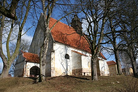
Parish Church of All Saints

Memorial stone for the fallen of the First World War

school
.JPG)
.JPG)
.JPG)
Sons and daughters of the church
- Karel Hugo Hilar (1885–1935), actually Karel Bakule, theater director, critic and author
- Karel Kudrna (* 1924), geophysicist, Deputy Minister of Education of Czechoslovakia from 1972 to 1975
Individual evidence
- ↑ Český statistický úřad - The population of the Czech municipalities as of January 1, 2019 (PDF; 0.8 MiB)
- ↑ Johann Gottfried Sommer : The Kingdom of Bohemia. Represented statistically and topographically. Volume 10: Tabor Circle. Ehrlich, Prague 1842, p. 34.