
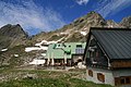
Mindelheimer Hut
| Mindelheimer hut DAV hut category I. |
||
|---|---|---|
 Mindelheimer hut before Kemptner Kopf |
||
| location | Bavaria , Germany ; Swabia , Oberallgäu district ; Valley location: Oberstdorf | |
| Mountain range | Southeastern Walsertal Mountains , Allgäu Alps | |
| Geographical location: | 47 ° 17 '31 " N , 10 ° 11' 42" E | |
| Altitude | 2013 m above sea level NN | |
|
||
| owner | DAV - Mindelheim section | |
| Built | 1920 | |
| Construction type | hut | |
| Development | Material ropeway | |
| Usual opening times | Mid-June to the end of October | |
| accommodation | 0 beds, 120 camps | |
| Winter room | 25 bearings | |
| Web link | Mindelheimer Hut | |
| Hut directory | ÖAV DAV | |

The Mindelheimer Hütte ( 2013 m above sea level ) is an alpine club hut in the Allgäu Alps . It belongs to the Mindelheim section of the German Alpine Club and was built in 1920. Since 1997 it has had the environmental seal of approval for Alpine Club huts . Depending on the weather and snow conditions, the hut is open from mid-June to October and offers space for 120 people to stay overnight. As a base near the popular Mindelheim via ferrata , it is frequently frequented in summer and has more than 9,000 overnight stays per year.
history
At the turn of the 20th century , the Mindelheim Section was looking for its own area of work in the Alps . The chairman at the time found what he was looking for in the area around the Schafalpenköpfe and in 1914 the section acquired a plot of land the size of a day's work . After the First World War , roads and an emergency and construction hut were completed. The opening of the first Mindelheimer hut, it was the emergency hut, took place on August 29, 1920. It had 24 beds.
As a result, there were various attempts to renew the hut and to provide it with a material ropeway, but all failed. At the end of the Second World War , the hut was occupied by French troops . It was not until the 1950s that the new building and the expansion to 70 beds succeeded. In the 1960s, the long-awaited material ropeway from the Rappenalptal was built and the first sewage treatment plant was built. As a result, there were numerous renovations and additions to the hut.
In 1977 Jochen and Centa Krupinski took over the hut, which they still run today. For the 25th anniversary of the new building, a meeting of the Mindelheim city council took place in the hut. As part of the sanitary requirements imposed by the Oberallgäu district office , the hut was replaced after 1989. This gradually received a photovoltaic system and a fully biological sewage treatment plant . In 1997, the Mindelheimer Hütte was one of the first to be awarded the Alpine Club's environmental seal of approval . After 2000, the old hut was converted and extensive modernization measures in the areas of water and energy supply took place. Since 2001 there has been a Meteomedia weather station on the hut . It represents the southernmost location of this weather service in Germany.
Approach
The valley locations of the Mindelheimer Hütte include Warth ( 1495 m ) and Mittelberg ( 1215 m ) in the Kleinwalsertal . Surefootedness and sometimes a head for heights are required for the ascent to the hut .
From Mittelberg in the north, the hiking trail leads through the Wildental to the hut in around three hours. The path 441 extends over the lower Wiesalpe ( 1290 m ), the wild ravine and the rear Wildalpe ( 1777 m ) up to the notch Kempten ( 2103 m ). In their area, steep rocky terrain that is partially secured with wire ropes has to be overcome. From there the path runs down to the hut.
The hut can be reached in just under three hours from the Lech Valley in the south. Here it is path 445 , which leads from Lechleiten over the Schrofenpass ( 1685 m ) and the valley of the Haldenwanger brook to the refuge.
Other, but longer, approaches begin in the Stillach valley in Oberstdorf . On the one hand there is the possibility to take the Fellhornbahn to the summit station ( 1967 m ). From there down to the Gundsattel and further under the Kanzelwand crossing on the Krumbacher Höhenweg descending to the Kühgundalpe ( 1745 m ). Now up again to the Rossgundscharte and on the high path crossing the Schafalpenköpfe to the Mindelheimer Hütte. This variant takes about four hours. Alternatively, take the bus to shortly after Birgsau and continue on the road through the Stillach and Rappenalptal valleys in about six kilometers to the Schwarzen Hütte ( 1242 m ); from here easy on path 441 up to the hut; Total duration for this tour is approximately four and a half hours.
Transitions

From the Mindelheimer Hütte there is a transition to the Fiderepasshütte ( 2067 m ) or Rappenseehütte ( 2091 m ). Usually the Mindelheimer Hütte station is between the two huts on the "Great Crossing of the Allgäu Alps".
- There are two routes to get from the Mindelheimer- to the Fiderepasshütte :
- On the Krumbacher Höhenweg under the Schafalpenköpf to the Fiderescharte ( 2199 m ) and down to the hut (2½ hours).
- Via the Schafalpenköpfe and the Kemptner Kopf on the Mindelheim via ferrata to the Kemptner Scharte ( difficulty C , at least four hours, alpine experience and via ferrata equipment).
- The path to the Rappenseehütte initially runs in the opposite direction to the access from the Lech Valley. At the Schrofenpass the path branches off to the Salzbücheljoch and crosses under the Biberkopf to the Mutzentobel and from there to the Rappenseehütte (4½ hours).
- To the Widdersteinhütte ( 2009 m ).
summit
In addition to the Mindelheim via ferrata, there are other ways to climb the summit .
- First the Angererkopf ( 2263 m ), which can be climbed from path 444 with difficulty and with a difficulty of I-II over the notch to the Liechelkopf and the west ridge.
- The Liechelkopf ( 2384 m ), two and a half hours away, is close to the hut, but still not very climbed . Its ascent from path 444 runs in partly very steep terrain and the path is not marked. Footprints can help with orientation in the ascent from the southeast. From the Liechelkopf there is the possibility of crossing to the Elferkopf ( 2387 m ). It runs on the exposed ridge and requires climbing ability in the second degree.
- An easy tour is the ascent of the Geißhorn ( 2366 m ) via path 444 in just under two hours.
photos

"Back"

terrace

Winter room with anemometer

Photovoltaic test system in the winter room
View from the winter room onto the terrace


Filmography
- The man and the mountain - an Allgäu hut landlord legend . Brigitte Kronberger, 2009: Documentation about hut keeper Jochen Krupinski
literature
- Markus Woelfle: The Mindelheimer Hütte - Allgäu jewelry box . In: Bergsteiger 5/2005 (pp. 40–45)
- Stefan Heiligensetzer: Article about the Mindelheimer Hütte ( Memento from December 27, 2008 in the Internet Archive ) . In: Allgäuer Zeitung 08/2006
- Josef Schafnitzel, Stephan Baur: Climbing guide Mindelheimer Hütte - Mindelheimer Klettersteig . SL-Verlag, Kempten 2008, ISBN 978-3981032031
Web links
- Website of the Mindelheimer Hütte
- Website of the Mindelheim section
- Current weather data for the Mindelheimer Hütte from Meteomedia
- Isabel Meixner, Silke Lode and Heiner Effern: Seven huts in the Bavarian mountains that you should know: Mindelheimer Hütte, May 9, 2018
Individual evidence
- ^ Section Mindelheim: History of the Mindelheimer Hütte . Retrieved August 3, 2011.
- ^ Günther Träumer: "Mindelheimer Hütte" weather station . (PDF, 100 kB) Accessed August 3, 2011.
- ↑ Dieter Seibert: Alpine Club Guide alpine - Allgäu Alps and Ammergau Alps . 17th edition. Bergverlag Rother , Munich 2008, ISBN 978-3-7633-1126-2 (p. 81f).
- ^ Section Mindelheim: Access . Retrieved August 3, 2011.
- ↑ Dieter Seibert: Alpine Club Guide alpine - Allgäu Alps and Ammergau Alps . 17th edition. Bergverlag Rother, Munich 2008 (p. 111ff).
- ↑ Dieter Wissekal: Mindelheimer ferrata . Retrieved May 6, 2010.
- ↑ a b Dieter Seibert: Alpine Club Guide alpine - Allgäu Alps and Ammergau Alps . 17th edition. Bergverlag Rother, Munich 2008 (p. 189f).
- ^ Section Mindelheim: Mountain tours . Retrieved August 3, 2011.
- ↑ Dieter Seibert: Alpine Club Guide alpine - Allgäu Alps and Ammergau Alps . 17th edition. Bergverlag Rother, Munich 2008 (p. 191f).