
Beaver head
| Beaver head | ||
|---|---|---|
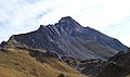
 Biberkopf from the northwest, near the Mindelheimer hut seen |
||
| height | 2599 m above sea level A. | |
| location | Border Bavaria , Germany / Tyrol , Austria | |
| Mountains | Central main ridge , Allgäu Alps | |
| Dominance | 3.5 km → Hohes Licht | |
| Notch height | 337 m ↓ Great Steinscharte | |
| Coordinates | 47 ° 16 '14 " N , 10 ° 13' 56" E | |
|
||
| First ascent | 1853 as part of the national survey | |
| Normal way | Rappenseehütte - marked path (rope insurance in places) - west ridge - summit | |

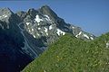
The Biberkopf is a 2,599 meter high mountain in the Alps on the border of Germany and Austria .
Location and surroundings
It is located in the main ridge of the Allgäu Alps on the border between Bavaria and Tyrol and the Oberallgäu district with the Reutte district . There it is located around 15.5 kilometers south-southwest of Oberstdorf and only around 2.5 kilometers east of the Schrofen Pass (depending on the beeline ).
The Biberkopf is sometimes referred to as the southernmost point of Bavaria or Germany, although the summit is 110 meters further north than the Haldenwanger Eck, which is 4,088 meters further west (as the crow flies) .
geology
Due to its fascinating shape, it is one of the most impressive mountains in the German Alps. Geologically , the summit body is made up of intensely folded dolomite that was pushed onto marls . The very pure dolomite causes the mountain's lack of vegetation, as the content of clay minerals in the weathered rock is too low for sufficient soil formation. In contrast, a rich flora can be found after the transition into the marl layers.
Ascent
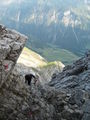
Marked paths lead from the Rappenseehütte and from Lechleiten near Warth to the Biberkopf. The time required is around 2.5 or 3 hours. Both ascent routes traverse exposed, steep rock and rubble parts, so sure-footedness is required. However, due to the installation of wire ropes and climbing aids, the ascent is also possible for less climbers ( difficulty level UIAA I ). It is not advisable to go up in wet, snowy or slippery conditions. On the north side, there is often leftover snow all year round.
The first ascent of the Biberkopf south face was achieved in 1922 by the Allgäu alpinist Hermann Grosselfinger .
Summit cross
The summit cross was in 1959 by the local branch Oberguenzburg the DAV - Section who is also the way conservation is subject to the mountain, built Allgäu / Kempten in wood. The cross was renewed in 1994.
photos
Flat summit structure from the south
On the rise

From the southwest from the Saloberkopf
From the northeast from the Kleiner Rappenkopf

In the foreground the Walser settlement Bürstegg

Biberkopf with Bürstegg in summer


Literature and map
- Dieter Seibert, Alpine Club Guide Allgäu Alps and Ammergau Alps , Munich 2004, ISBN 3-7633-1126-2
- Alpine club map 1: 25,000, sheet 3/2, Lechtal Alps, Arlberg area (the Biberkopf is here on the northern edge of the map, the Rappenseehütte is already outside)
- Bavarian State Surveying Office, 1: 50,000, special print Allgäu Alps , sheet UK L8