Bürstegg
| Bürstegg ( hamlet ) | ||
|---|---|---|
|
|
||
| Basic data | ||
| Pole. District , state | Bludenz (BZ), Vorarlberg | |
| Judicial district | Bludenz | |
| Pole. local community | Lech ( KG Lech) | |
| Locality | Lech | |
| Coordinates | 47 ° 14 '18 " N , 10 ° 9' 34" E | |
| Statistical identification | ||
| Counting district / district | Lech (80113 000) | |
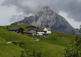
 Bürstegg with Biberkopf |
||
| Source: STAT : index of places ; BEV : GEONAM ; VoGIS | ||
The Bürstegg settlement is located at an altitude of 1719 m above sea level. A. the highest Walser settlement in the Austrian state of Vorarlberg . Once inhabited all year round, the settlement at the foot of the Warther Karhorn in the municipal area of Lech am Arlberg is now only used as an alp during the summer months.
The area at the foot of the Karhorn has been inhabited by people since the Walsers settled the rearmost mountain regions of Vorarlberg around the year 1300. Since the Bürstegg hillside settlement was above the tree line and therefore no firewood was available, peat was cut around the small settlement and dried in the dry arbor under the roof gable of the stable building that still exists today. The name "Bürstegg" is derived from the alpine borst grass , which grew in the marshland around Bürstegg and is popularly known as "Burst" or "Bürstl".
Since 1695, Bürstegg has had its own Catholic branch church, dedicated to St. Martin . Today the church with its baroque altar, a statue, statues and some panel paintings is a listed building . The existence of 13 families in as many houses in Bürstegg is documented for 1835, but the place is likely to have been evacuated as early as 1898 due to the difficult situation of the mountain farmers. As a result of this, Bürstegg is only used as a high alpine pasture in the summer months and is increasingly used by hikers during this time.
Web links
- The old Walser settlement "Bürstegg" in the travel portal tiscover.com .

