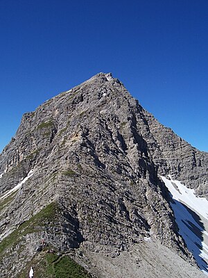
Karhorn
| Karhorn | ||
|---|---|---|
|
The Karhorn from the north |
||
| height | 2416 m above sea level A. | |
| location | Vorarlberg , Austria | |
| Mountains | Lechquellen Mountains | |
| Dominance | 3.7 km → Rappenspitze | |
| Notch height | 706 m ↓ Auenfeldsattel | |
| Coordinates | 47 ° 14 '53 " N , 10 ° 9' 4" E | |
|
|
||
| Normal way | From the Auenfelder Sattel over the south-facing path | |
The Karhorn is 2416 m above sea level. A. high mountain in the Lechquellen Mountains . It is the main summit of the Karhorn group named after him. It is located southwest of Warth between the Auenfelder Horn in the northwest and the Warther Horn in the northeast.
The western summit of the Karhorn was called Durechelenstein ("pierced stone") in the Middle Ages, documented in a deed of donation from Heinrich IV. To the bishopric of Augsburg from 1059. The name had been forgotten, so that in science it was also about the one laid down in the deed The borderline was unclear. It was only Walther Flaig who identified the western summit of the Karhorn, which actually has a hole, with the Durechelenstein of the document and gave it back its old name. However, it has not yet prevailed again.
Ascent
The Karhorn can be climbed from the Auenfelder Sattel on a marked trail over the Südsporn with alpine difficulty UIAA I or over the Karhorn via ferrata, a medium-difficulty via ferrata, from the saddle between Karhorn and Warther Horn.
literature
- Eugen E. Hüsler: Via ferrata atlas Alps . Munich, Bruckmann Verlag, 6th edition 2005. ISBN 3-7654-4213-5
Web links
Individual evidence
- ↑ AV-Guide Lechquellengebirge, keyword Karhorn


