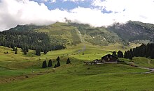
Gerschnialp
The Gerschnialp is an alp at 1,200 to 1,350 m above sea level. M. above the Engelbergertal in the Titlis and Joch pass areas in central Switzerland . It belongs to the municipality of Engelberg , in the south of which it is located, and also includes the Hinterstafel dairy and the Unter Trüebsee alp , the western part of which is already in the municipality of Wolfenschiessen in the canton of Nidwalden .
location
The Gerschnialp forms a plateau at the first stage of the layer Titlis Tearing Noll - Jochstock -Massivs below the powerful Gerschniberges to the plateau of the upper Trüebsee Alp, which both from the lying Kalksediment-benches of the ceiling of the Aar Massif build. It is separated from the valley village by a wooded escarpment and can be reached via a cooperative alpine access road. The Trüebenbach rises in the corridor Unter Trüebsee, which is fed underground by the Trüebsee and drains the area to the Engelberger Aa .
tourism
A funicular takes you from Engelberg to the Gerschnialp. Until the Engelberg-Trübsee gondola lift was replaced by the TITLIS Xpress Engelberg-Trübsee in 2015, the Alp was also an intermediate station for the Titlis lift . Since then, there is only a connection to Trübsee and Mount Titlis in winter via the Gerschnialp – Trübsee cable car.
There are two inns on the Gerschnialp ( Ritz , Unter Trübsee , from there the Älplerseil cable car to Trübsee). In winter, three children's lifts are installed and numerous cross-country trails and snowshoe trails have been created. The forest road is used as a toboggan run in winter .
The Zschokke House ( 1262 m above sea level ) of the student body of the University of Basel , named after Friedrich Zschokke , and a contract shooting range are located on the Alp . A hiking trail leads to the alpine area Arniwang and on the Juchlipass ( 2171 m above sea level. M. ) or Bockigrat ( 2200 m above sea level. M. ) to Melchtal .
The alpine region Gerschnialp-Hinterstafel has the alp cadastre No. 6191, the summer dawn in the alp Unter Trüebsee was discontinued in the 1950s.
Web links
- Gerschnialp - Hinterstafel , Alp cadastre entry of the Swiss Alpine Association and the Swiss Working Group for Mountain Regions (SAB), alporama.ch
Individual evidence
- ↑ see overview map Engelberg ( Memento of the original from January 27, 2008 in the Internet Archive ) Info: The archive link has been inserted automatically and has not yet been checked. Please check the original and archive link according to the instructions and then remove this notice. , www.engelberg.ch
- ↑ Entry in the commercial register of the canton of Obwalden - Strassengenossenschaft Alp- und Forststrasse Gerschnialp, Engelberg
- ↑ Gerschnialp toboggan run ( page no longer available , search in web archives ) Info: The link was automatically marked as defective. Please check the link according to the instructions and then remove this notice. , alltrack.ch
- ↑ Zschokke-Haus ( Memento of the original dated February 7, 2005 in the Internet Archive ) Info: The archive link was inserted automatically and has not yet been checked. Please check the original and archive link according to the instructions and then remove this notice. , zschokkehaus.ch
- ↑ http://www.wandersite.ch/Winterwandern/W31_Winter_NW.html , visited on February 17, 2008
- ^ Thomas Wagner: Mountain restaurant Untertrübsee. In: Frequency in Wolfenschiessener Dorf. Information magazine of the community Wolfenschiessen, 5 / February 2007, p. 30f ( web document ( page no longer available , search in web archives ) Info: The link was automatically marked as defective. Please check the link according to the instructions and then remove this note. , PDF 3 MB, with pictures of the hut)
Coordinates: 46 ° 48 ′ 24 " N , 8 ° 24 ′ 2" E ; CH1903: six hundred and seventy-three thousand four hundred twenty-six / 184387


