Sunniggrathütte
| Sunniggrathütte | ||
|---|---|---|
| location | southeast of the Jacobean ; Canton of Uri , Switzerland ; Valley location: Amsteg / Intschi | |
| Mountain range | Uri Alps | |
| Geographical location: | 691 271 / 182046 | |
| Altitude | 1978 m above sea level M. | |
|
|
||
| owner | Gnos family | |
| Construction type | hut | |
| Usual opening times | July to August | |
| accommodation | 0 beds, 30 camps | |
| Hut directory | SAC | |
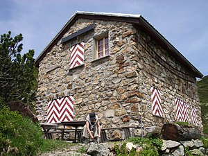
The Sunniggrathütte is a privately owned mountain hut in the canton of Uri ( Switzerland ).
It lies on a prominent mountain shoulder above Intschi , high above the central Urner Reuss Valley at 1978 m above sea level. M. height in the Urner Alps . There is a pond nearby ( Sunnig Grat Seeli 1960 m above sea level ), which is used as a bathing lake .
The Sunnig Grat , a little to the north, is an excellent vantage point into the Reuss Valley and the three-thousand-meter peaks of the Uri, Glarus and Schwyz Alps .
The hut can be reached from Intschi or Amsteg by cable car to Arnisee, from there in 1.5 to 2 hours and from Gurtnellen Dorf via Arnisee in approx. 3.5 hours. It offers 30 beds (dormitory) and is open from the beginning of July to the end of August in good weather, the rest of the time on request.
The hut is suitable as a starting point for circular hikes and as a stage stop for hikes with crossings to the Leutschach and Kröntenhütte .


