
Rautispitz
| Rautispitz | ||
|---|---|---|
 From Näfels; Rautispitz on the right, with a high nose to the left. Vrenelisgärtli in the background. |
||
| height | 2283 m above sea level M. | |
| location | Canton of Glarus , Switzerland | |
| Mountains | Glarus Alps | |
| Dominance | 5.5 km → Vorder Glärnisch | |
| Notch height | 470 m ↓ Längeneggpass | |
| Coordinates | 720 738 / 214597 | |
|
||
| particularities | Protected area | |
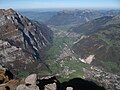
 Rautispitz from the Höchnase; in the valley floor Näfels and Mollis, in the background the Walensee |
||

The Rautispitz is a summit in the anterior Glarnerland and stands prominently to the west above Netstal in Switzerland . It is 2283 meters high and is more than 1800 meters above the Linth valley , which flows northeast to the nearby Walensee , which is 419 meters above sea level. The summit rises about 600 meters north of the Wiggis , which is just one meter deeper , with which it is perceived as a mountain from the valley. The municipal boundary between Näfels and Netstal runs on the mountain peaks.
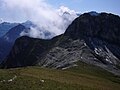
The neighboring Wiggis rises directly above Netstal and consists of limestones from the Jura and Cretaceous periods . At the transition to the Rautispitz the rock becomes strikingly white as well as brittle and slatey.
Ascent
The summit pair Rautispitz and Wiggis is one of the classic destinations in the network of mountain hiking trails in the canton of Glarus. The starting point for the ascent is the Obersee north of it , from where you can hike over the Rautialp or climb steeply through the northern flank via Geisskappel. From the south, from the Klöntal with the Klöntalersee running towards the west, the steep southern flank towards Wiggis can be climbed. The Rautispitz can be reached on hiking trails; However, if you want to climb both peaks, there is only one mountain hiking connection ( T4 ) and the ascent or descent from Wiggis into the Klöntal is very steep.
situation
View from the south; left upswing to Wiggis and Rautispitz. Places: Glarus below right, first Riedern on the left, then Netstal, Mollis / Näfels and Niederurnen at the valley exit

The high valley of the Rautialp leads more gently than expected from the west to the summit.
If you want to continue to Wiggis (right), you have to cross its flank in the direction of Höchnase. South facing.

The imposing valley entrance into the Glarnerland seen from the north; Rautispitz on the right, the Vorderglärnisch on the left and the Vrenelisgärtli in the middle.

Rautispitz on the left and Wiggis at the end of the ridge line from the southwest; Aerial view


