
Löbauer water
|
Löbauer Water Lubata |
||
 The Löbauer water in the Georgewitzer scale |
||
| Data | ||
| Water code | EN : 5822 | |
| location | Saxony , Germany | |
| River system | Elbe | |
| Drain over | Spree → Havel → Elbe → North Sea | |
| origin | Confluence at Löbau 51 ° 4 ′ 35 ″ N , 14 ° 40 ′ 4 ″ E |
|
| Source height | approx. 254 m above sea level NN | |
| muzzle | at Lömischau in the Spree Coordinates: 51 ° 16 '45 " N , 14 ° 33' 52" E 51 ° 16 '45 " N , 14 ° 33' 52" E |
|
| Mouth height | 139 m above sea level NN | |
| Height difference | approx. 115 m | |
| Bottom slope | approx. 2 ‰ | |
| length | 58 km | |
| Discharge at the gauge Gröditz 1 A Eo : 195 km² Location: 19.4 km above the mouth |
NNQ (07/08/1934) MNQ 1927/2005 MQ 1927/2005 Mq 1927/2005 MHQ 1927/2005 HHQ (07/20/1981) |
20 l / s 291 l / s 1.31 m³ / s 6.7 l / (s km²) 23.2 m³ / s 85 m³ / s |
| Left tributaries | Rarely pure , Kotitzer water | |
| Right tributaries | Rosenhainer Water , Buchholzer Water , Altes Fliess | |
The Löbauer Wasser (popularly also the Löbau ; Upper Sorbian Lubata , formerly Lubotna ) is a right tributary of the Spree in Saxony .
course
It is created at the Zimmermühle in the Löbau district of Ebersdorf in Liebesdörfel , through the confluence of the Großschweidnitz water and the Cunnersdorfer water .
The river runs past Ebersdorf to the north between the city center of Löbau and Löbauer Berg . North of the city follows the village of Georgewitz , followed by a narrow rock valley, the Georgewitzer Skala , which extends as far as Opole . At Kleinradmeritz the run begins to the northwest through a flat valley with many meanders , where the places Glossen , Grube , Trauschwitz , Lautitz , Maltitz and Wasserkretscham are located.
Above the town of Weißenberg , a deeply cut river valley begins with larger river loops. Here the Löbauer Wasser runs south of the federal motorway 4 ( A4 ) and forms the rock valley of the Gröditzer Skala between Weicha and Gröditz . The further course leads west past Nechern and Belgern , where the river forms a common shallow valley with the Kotitzer water and is connected to this via ditches. At Cannewitz the courses of the two bodies of water separate again and above Rackel the river crosses under the A4 to the north. A flat landscape follows between the Malschwitz districts of Baruth and Buchwalde , in which the Löbauer water feeds several ditches for the pond landscape near Guttau . Here the Löbauer water flows between the Malschwitz districts of Guttau and Brösa and flows into the Spree after 58 km at the Malschwitz district of Lömischau on the right .
From Glossen to the mouth at Lömischau, the “Mühlenweg” theme trail runs along the many former mills .

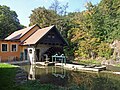
Watermill pit

Weissenberg Upper Mill
Niedermühle Weißenberg


Tributaries
- Rarely pure , in the Löbauer district of Tiefendorf , left
- Rosenhainer Wasser , near Kleinradmeritz, on the right
- Buchholzer Wasser , at Wasserkretscham, right
- Kotitzer Wasser , near Guttau, left
- Altes Fließ, near Lömischau, on the right
source
The origin of the Löbauer water is usually given in the Löbauer district Ebersdorf from the confluence of the Großschweidnitz water and the Cunnersdorfer water. However, there are a number of stories and legends about the origin. The Hochstein and the Höllengrundgraben as well as the villages of Großschweidnitz , Oberschönbach and Obercunnersdorf are often mentioned as sources .
Web links
Individual evidence
- ↑ Hydrological Handbook. (PDF; 637 kB) Part 3 - Main aquatic values. Free State of Saxony - State Office for Environment and Geology, p. 66 , accessed on December 25, 2017 .
- ↑ Peter Emerich: The Löbauer water. In: loebaufoto.de. Peter Emerich, September 2, 2018, accessed September 2, 2018 .