Cannewitz (Malschwitz)
|
Cannewitz
Skanecy Community Malschwitz
Coordinates: 51 ° 12 ′ 26 ″ N , 14 ° 34 ′ 5 ″ E
|
|
|---|---|
| Height : | 153–161 m above sea level NN |
| Residents : | 82 (December 31, 2016) |
| Incorporation : | January 1, 1957 |
| Incorporated into: | Rackel |
| Postal code : | 02694 |
| Area code : | 035932 |
|
Tailor mill at Löbauer Wasser, Cannewitz
|
|
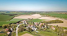
Cannewitz , in Upper Sorbian , is a village in the East Saxon district of Bautzen and has been part of the Malschwitz community since 1994 . It is located in Upper Lusatia and is in the Sorbian settlement area .
geography
Cannewitz is a round hamlet village expanded like a square about 11 km east of Bautzen and 5 km south-east of Malschwitz. It is located in the common floodplain of Kotitzer and Löbauer Wasser , whereby the former flows through the place and the latter runs somewhat to the east. Despite their proximity to each other - in places they are only 100 meters apart - the confluence only occurs a few kilometers to the north. Both in the south and in the east the terrain rises towards the Oberlausitzer Gefilde, while the western surroundings are relatively flat up to the Kreckwitzer heights and in the north.
A local expansion consisting of five individual properties developed around the old mill southeast of the own village on Löbauer Wasser.
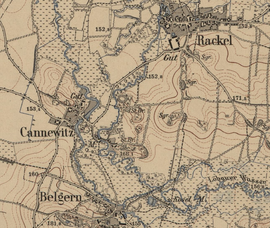
The neighboring towns are Rackel in the northeast, Belgern in the south and Preititz in the northwest.
history
The place was first mentioned in 1368 as Kanewicz , but the castle ramparts , located in a curve of the Löbauer Water between Cannewitz and Rackel, represent a remnant of much older settlement. The other part belonged to the Bautzen cathedral monastery.
Cannewitz was an independent rural municipality with the district of Belgern until January 1, 1957 (since 1936). Then it was incorporated into Rackel, with Belgern being reclassified to Wurschen and now part of Weißenberg. Cannewitz came with Rackel first in 1974 to the community of Baruth, then in 1994 to the new large community of Malschwitz.
Place name
The place name is of Sorbian origin and has the typical Slavic ending -itz . The exact meaning is controversial, but it is possible to derive it from the personal name Kan or Kańa ( from ancient Slavic * kaniti = "entertain, invite, prompt "). Historical forms of the name include: a. Canewicz (1390), Canewitz (1510), Cannwitz (1658) and from 1768 the current form of the name is recorded.
population
Cannewitz was in 1834 with 144 inhabitants almost twice as big as today; Until the 20th century, the number of inhabitants fell by half. In 1884/85 Arnošt Muka had 120 inhabitants, 115 of whom were Sorbs . Only since the middle of the 20th century has the use of Sorbian in the village declined due to assimilation and the influx of German speakers.
The almost exclusively Evangelical-Lutheran population was probably originally parish to Kleinbautzen , but has belonged to the Gröditz parish since the 16th century .
Infrastructure
The A4 ( Dresden - Breslau ) leads directly north past the place; however, the next connection points are 9 ( Weißenberg ) or 8 km ( Bautzen-Ost ) away. Bautzen airfield is located a little to the southwest .
Web links
swell
- Cannewitz (Malschwitz) in the Digital Historical Directory of Saxony
- Olaf Bastian, Henriette Joseph, Haik Thomas Porada: Oberlausitzer Heide- und Teichlandschaft - a regional study , Böhlau Verlag, Cologne / Weimar 2005


