Pliesskowitz
|
Pliesskowitz
Plusnikecy Community Malschwitz
Coordinates: 51 ° 13 ′ 37 ″ N , 14 ° 30 ′ 22 ″ E
|
|
|---|---|
| Height : | 150 m above sea level NN |
| Residents : | 211 (December 31, 2016) |
| Incorporation : | April 1, 1936 |
| Postal code : | 02694 |
| Area code : | 035932 |
Pliesskowitz , Upper Sorbian , is a village in the East Saxon district of Bautzen and has been part of the Malschwitz community since 1936 . It is located in Upper Lusatia and is in the Sorbian settlement area .
geography
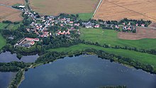
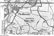
Pließkowitz is a medium-sized manor settlement with manor block areas, about seven kilometers northeast of Bautzen and 1.7 km southwest of Malschwitz on the border of the natural areas of Oberlausitzer Gefilde and Oberlausitzer Heide- und Teichgebiet . The old manor settlement forms the northern part of today's village and runs in a west-east direction, being separated from the actual manor at the west end by the Kleine Spree . The part of the settlement directly on Bautzener Landstrasse did not develop until the second half of the 20th century.
To the west and north of Pliesskowitz there are a number of fish ponds that are fed by the Kleine Spree. The road pond is located in the northeast between Pließkowitz and Malschwitz . The eastern area is used for agriculture, the soil type is brown earth . On the way to Kleinbautzen, the 188 m high Bauerberg rises up with the Teufelsstein , a striking rock formation that presumably served as a sun sanctuary in the past.
The neighboring towns are Malschwitz in the northeast, Kleinbautzen in the southeast, Doberschütz in the southwest and Niedergurig and Briesing behind the ponds in the west.
history
The Slavic settlement was first mentioned in 1327 as an Allod with the name Pluskewicz and has been recorded as the manor of Petrus and Nycolaus since 1375 . A moated castle already existed near the present-day estate. Until the 19th century, the manorial rule in the place lay with the local manor, which existed throughout.
In May 1813 fierce fighting broke out in the course of the Battle of Bautzen for Pliesskowitz.
In 1914, the Pließkowitz estate owned a total of 224 hectares of the 298 hectares, including 28 hectares of water (ponds) and a distillery. There was also a mill in the village. The manor house was built in its current form in 1840.
Pließkowitz was an independent rural community until 1936; then it was incorporated into Malschwitz.
Place name
The place name on -itz is of Old Sorbian origin and in the theoretical original form Plusnikowica probably means something like "settlement in a damp, swampy place" or "place where the water ripples" - cf. pluskotać (“splash”) in modern Upper Sorbian.
Numerous different forms of name have been mentioned over the centuries, including a. Plussinkewicz (1399), Plußkewicz (1419), Plißinckwicz (1447), Plißkwitz (1485), Plußnickewitz , Pluschkewitcz (both 1503) and from 1791 the current form. Plischwitz is also mentioned as a colloquial term in maps from 1844 .
population
Pliesskowitz was a relatively large place as early as the 18th century; In 1834 it had 207 inhabitants. This number increased steadily through the 19th century. In 1884/85 Arnošt Muka had 244 inhabitants, 233 of whom were Sorbs . In 1925 the majority were still speaking Sorbian. The use of Sorbian has since declined in the town.
In the second half of the 20th century, the population continued to grow until 1990. After the political change, there was a steady decline.
Since the Reformation the population has been predominantly Evangelical Lutheran; in 1925 there were also 10% Catholics. The evangelical portion has been parish to Malschwitz since the 16th century.
Economy and Infrastructure
State Road 109 (Bautzen - Niesky ) runs right through Pließkowitz. The federal highway 156 (Bautzen - Weißwasser ) is only three kilometers away. The Bautzen-Ost junction of the A 4 is five kilometers away.
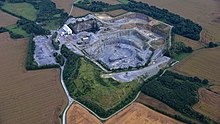
There are large granodiorite quarries on the Bauerberg and on the Schafberg to the south .
swell
Pließkowitz in the Digital Historical Directory of Saxony
- Olaf Bastian, Henriette Joseph, Haik Thomas Porada: Oberlausitzer Heide- und Teichlandschaft - a regional study , Böhlau Verlag, Cologne / Weimar 2005, p. 309 f.
- ^ Walter Wenzel: Oberlausitzer Ortnamesbuch. Domowina-Verlag, Bautzen 2008, p. 134
- ↑ Ernst Tschernik: The development of the Sorbian population . Akademie-Verlag, Berlin 1954.


