
Lerchenberg radio station
|
Lerchenberg radio station
|
||||
|---|---|---|---|---|
 |
||||
| Basic data | ||||
| Place: | Validlingen | |||
| Country: | Baden-Württemberg | |||
| Country: | Germany | |||
| Altitude : | 599 m above sea level NHN | |||
| Coordinates: 48 ° 39 ′ 46.8 " N , 8 ° 47 ′ 36.6" E | ||||
| Use: | Telecommunication system | |||
| Accessibility: | Transmission system not accessible to the public | |||
| Owner : | Ministry of the Interior of Baden-Württemberg | |||
| Data on the transmission system | ||||
| Height of the towers / masts : | 1 × 81 m | |||
| Waveband : | VHF, UHF BOS radio | |||
| Radio : | LW broadcast , MW broadcast , KW broadcast , VHF broadcast | |||
| Send type: | Mobile radio service , fixed radio service for BOS | |||
| Position map | ||||
|
||||


The radio station Lerchenberg is a telecommunication facility on the Lerchenberg north-east of the Wildberg district of Validlingen in the district of Calw . From here, the radio networks of the police, fire brigade and disaster control are coordinated throughout the country. The facility is operated by the Baden-Württemberg Ministry of the Interior .
The most conspicuous structure on the site is an 81 meter high telecommunications tower made of reinforced concrete, which serves, among other things, as a carrier for 70 cm directional antennas as well as numerous 4 m antennas. The system also has several dipole antennas for shortwave .
The facility was also used for civil defense until 1992 , so there are still several underground bunkers on the site .
gallery

81 meter high telecommunications tower
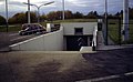
Access to an underground bunker


Individual evidence
- ↑ Section 66, Information and Communication Department of the Karlsruhe Regional Council ( page no longer available , search in web archives ) Info: The link was automatically marked as defective. Please check the link according to the instructions and then remove this notice.
- ^ Decision of the Baden-Württemberg Ministerial Council of September 29, 1992