Eglosheim
|
Eglosheim
City of Ludwigsburg
Coordinates: 48 ° 54 ′ 30 ″ N , 9 ° 10 ′ 7 ″ E
|
|
|---|---|
| Area : | 4.47 km² |
| Residents : | 11,858 (Dec. 31, 2015) |
| Population density : | 2,653 inhabitants / km² |
| Incorporation : | 1901 |
| Postal code : | 71634 |
| Area code : | 07141 |

Eglosheim is a district of the district town of Ludwigsburg that was incorporated in 1901 .
Geographical location
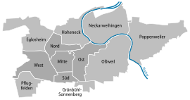
Eglosheim is located northwest of the core city of Ludwigsburg between the Favoritepark and Hohenasperg and borders on Tamm and Freiberg am Neckar to the north, Hoheneck and Ludwigsburg-Nord to the east, Ludwigsburg-West to the south and Asperg to the west .
history
The name Eglosheim probably comes from a settlement of Egolf or Egilolf. In 844, goods from Hegoluesheim are also mentioned in a deed of donation from Lorsch Abbey. The next mention comes in the 12th century. In this deed of ownership of the Hirsau Monastery, among other nobles, Egilolf de Eglessheim and his brother also appear as witnesses. The former fortified seat of the Lords of Eglosheim is believed to be south of the church. It is assumed that Eglosheim belonged to the Ingersheim county and from the middle of the 12th century to the Tübingen Palatinate. From 1308 the Count Palatine sold part of their property to Count Eberhard von Württemberg. In 1536 the entire place came to the Duchy of Württemberg and belonged to the office of Grüningen . From its establishment until the Reformation , the Eglosheim parish belonged to the Land Chapter Grüningen in the Archdiaconate Trinity of the Diocese of Speyer .
During the Thirty Years War in 1635, the village was largely burned down by imperial troops when the Hohenasperg fortress was besieged . After the end of the war, only the church, wine press, forester's house and three houses of 145 buildings were probably left. In 1707 the French burned down about 30 buildings. With the construction of Ludwigsburg Palace, new streets were created and the Monrepos Lake Palace was built on Lake Eglosheim .
From 1800 new houses were built along today's Monreposstrasse. A parade ground for the Ludwigsburg garrison was built on the Hirschberg . At the end of the 19th century the population rose sharply, but the place remained rural. As early as 1901 Eglosheim was incorporated into Ludwigsburg. After the two world wars, the Hirschbergsiedlung and Straßenäcker residential areas were created. Due to the strong development, Eglosheim developed into the largest suburb of Ludwigsburg.
traffic
The federal road 27 runs through Eglosheim . The stop of the S-Bahn Favoritepark is located in Eglosheimer district . The federal highway 81 runs to the west of the district . The Ludwigsburg-Nord junction is located northwest of the district.
Attractions
The historic buildings in Eglosheim include the Protestant parish church of St. Katharina from the 15th century and the town hall from 1709, which lost its function in 1901.
Sons and daughters of the place
- Georg David Hardegg (1812–1879), merchant, one of the founders of the German Temple Society
- Ernst August Wagner (1874–1938), teacher, poet and mass murderer
- Paul Haegele (1894–1977), composer and local politician
Web links
- Social city of Eglosheim
- Eglosheim in the description of the Oberamt Ludwigsburg from 1859


