Grünbühl-Sonnenberg
|
Grünbühl-Sonnenberg
City of Ludwigsburg
Coordinates: 48 ° 52 ′ 52 ″ N , 9 ° 12 ′ 46 ″ E
|
|
|---|---|
| Area : | 71 ha |
| Residents : | 3656 (December 31, 2015) |
| Population density : | 5,149 inhabitants / km² |
| Postal code : | 71638 |
| Area code : | 07141 |
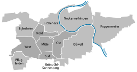
Grünbühl-Sonnenberg is a district of the Baden-Württemberg district town of Ludwigsburg .
Geographical location
Grünbühl-Sonnenberg is located southeast of the Ludwigsburg core city on the so-called Long Field . In the north it borders on the Ludwigsburg districts South, East and Oßweil . South of Grünbühl-Sonnenberg lies the Pattonville settlement, which belongs to Remseck and Kornwestheim .
history
Grünbühl-Sonnenberg was created by merging the former Ludwigsburg district of Grünbühl and the Sonnenberg settlement to the south of it . The new district was founded on January 1, 2013. At the end of 2015, Grünbühl-Sonnenberg had 3,656 inhabitants.
In 2015, Ludwigsburg was awarded a state prize for the social city Grünbühl-Sonnenberg / Karlshöhe redevelopment area as part of the “Stadt Bürger Dialog” project run by the Ministry of Economic Affairs .
Web links
Individual evidence
- ↑ [1]
- ↑ Grünbühl-Sonnenberg. In: ludwigsburg.de. City of Ludwigsburg, accessed on March 28, 2020 .
- ^ Urban district development and “social city” in Grünbühl-Sonnenberg. City of Ludwigsburg, accessed on November 24, 2017 .
