Doebach
| Doebach | ||
|
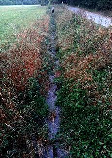
Dried out bed east of Heimerdingen |
||
| Data | ||
| Water code | DE : 2384674 | |
| location |
Neckar basin
|
|
| River system | Rhine | |
| Drain over | Glems → Enz → Neckar → Rhine → North Sea | |
| source | near the district of Heimerdingen 48 ° 51 ′ 7 ″ N , 8 ° 59 ′ 52 ″ E |
|
| muzzle | below the Glemsmühle near Korntal-Münchingen in the middle Glems coordinates: 48 ° 51 '11 " N , 9 ° 2' 57" E 48 ° 51 '11 " N , 9 ° 2' 57" E
|
|
| length | 4 km | |
| Catchment area | 16.677 km² | |
The Döbach is an approximately four kilometers long left and west tributary of the middle Glems on the district of the city of Ditzingen in the district of Ludwigsburg in Baden-Württemberg .
geography
course
The moat , which was expanded and partially relocated in the course of the land consolidation in 1968, begins in the "Schöckinger Grund" district a little east of the industrial area of the Heimerdingen district . It runs steadily in an easterly direction, soon crosses the markings of the district of Schöckingen , runs in a corridor between the Heimerdinger Forest in the north and the Hühnerwald in the south and, towards the end of its forest stretch, joins the longer and more catchable Aischbach stream from the right. After that, in the open corridor, it passes Schöckingen itself on the right and is then fed from the left by the Böhnlachgraben immediately before it passes under the L 1136 Hemmingen-Hirschlanden. It finally flows into the middle Glems from the left in the north-east corner of the city limits, a little below the Glemsmühle of Korntal-Münchingen .
Tributaries
- Aischbach , from the right and south-southwest, 2.4 km and 8.4 km²
- Böhnlachgraben , from the left and northwest, 2.5 km and 2.0 km²
Nature and reserve
The Döbachtal between the Schöckingen and Heimerdingen sewage treatment plants, Weihinger Grund, Greut, Hühnerwald and the adjacent areas was designated as a landscape protection area by ordinance of the Ludwigsburg district office of April 24, 1991 . The purpose is to preserve the cultural landscape with its orchards, hedges, grassland areas and the forest-open-air transition area and long-term protection against disruptive interference.
In 2003, the Döbach between Heimerdingen and Schöckingen was renatured in two places and its stream bed was redesigned in a natural way.
Individual evidence
- ^ Friedrich Huttenlocher , Hansjörg Dongus : Geographical land survey: The natural spatial units on sheet 170 Stuttgart. Federal Institute for Regional Studies, Bad Godesberg 1949, revised 1967. → Online map (PDF; 4.0 MB)
- ↑ a b State Institute for the Environment Baden-Württemberg (LUBW) ( information )
- ↑ Ordinance of the Ludwigsburg district office as a lower nature conservation authority on the landscape protection area “Döbachtal between Schöckingen and Heimerdingen sewage treatment plant, Weihinger Grund, Greut, Hühnerwald and adjacent areas” of April 24, 1991
- ^ Leonberger Kreiszeitung, July 10, 2003
literature
- Topographic map 1: 25,000 Baden-Württemberg, as single sheet No. 7119 Rutesheim and No. 7120 Stuttgart Northwest
Web links
- Map of the course and catchment area of the Döbach on: State Institute for the Environment Baden-Württemberg (LUBW) ( information )
- Map of the course and catchment area of the Döbach on: Geoportal Baden-Württemberg ( information )
- Measuring table sheets in the Deutsche Fotothek :
- 7119 Weissach from 1900
- 7120 Leonberg from 1896
