
Enzklösterle
| coat of arms | Germany map | |
|---|---|---|

|
Coordinates: 48 ° 40 ′ N , 8 ° 28 ′ E |
|
| Basic data | ||
| State : | Baden-Württemberg | |
| Administrative region : | Karlsruhe | |
| County : | Calw | |
| Height : | 590 m above sea level NHN | |
| Area : | 20.2 km 2 | |
| Residents: | 1249 (December 31, 2018) | |
| Population density : | 62 inhabitants per km 2 | |
| Postal code : | 75337 | |
| Area code : | 07085 | |
| License plate : | CW | |
| Community key : | 08 2 35 025 | |
| Community structure: | 4 districts | |
| Address of the municipal administration: |
Rathausweg 5 75337 Enzklösterle |
|
| Website : | ||
| Mayor : | Sascha Dengler | |
| Location of the municipality of Enzklösterle in the district of Calw | ||
  |
||

Enzklösterle is a municipality in the Calw district in Baden-Württemberg . It belongs to the Northern Black Forest region .
geography
Geographical location
The state-approved climatic health resort is located in the upper Enz Valley in the northern Black Forest at an altitude of 560 to 917 meters.
1790 ha (88%) of the 2020 ha municipality area are forest areas, 6% are used for agriculture, the rest is settlement and traffic area.
Neighboring communities
The municipality borders the city of Bad Wildbad in the north and east , Simmersfeld in the south-east, Seewald in the Freudenstadt district in the southwest and Gernsbach and Forbach in the Rastatt district in the west .
Community structure
The municipality of Enzklösterle is divided into the districts of Enzklösterle (capital of the municipality), Poppeltal, Gompelscheuer and Nonnenmiß, the northern half of which no longer belongs to Enzklösterle, but to the neighboring municipality of Bad Wildbad. The municipality includes the village of Enzklösterle, the hamlets of Gompelscheuer, Lappach, Mittelenztal, Poppeltal, Rohnbach and Süßbächle, the Hetschelhof farm and the southern part of Nonnenmiß. The desert areas of Birkenäckerle, Kaltbronn, Boppelseehaus and Zwickgabel are located in the municipality .

View of the Gompelscheuer part of the municipality of Enzklösterle (aerial view)

View from the foot of the Hirschkopf over the center of Enzklösterle to the Schöllkopf
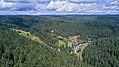
View of the Poppeltal district of the municipality of Enzklösterle (aerial view)

View of the district of Nonnenmiß in the municipality of Enzklösterle (aerial view)


history
The name of the municipality goes back to a Cistercian monastery founded in 1145, which was subordinated to the Herrenalb monastery in 1330 and was dissolved in 1536 after the Reformation. The place Enzklösterle belonged to Wildbad until 1826 and then became independent. In 1935 it merged with the municipality of Enzthal, which until 1829 belonged to the municipality of Simmersfeld. Although Enzthal was the larger municipality, the name "Enzklösterle" was chosen.
politics
mayor
- 1943–1945: Hermann Erhard
- 1945–1946: Jakob Waidelich (temporarily deployed)
- 1946–1948: Jakob Waidelich
- 1948–1978: Karl Schlag
- 1978–1987: Jochen K. Kübler
- 1988–1992: Robert Weiß
- 1992–2000: Manfred Wägerle
- 2000-2006: Klaus Mack
- 2006–2011: Michael Faschon (honorary BM)
- 2011–2019: Petra Nych (honorary BM)
- since 2019: Sascha Dengler (honorary BM)
Municipal council
After the local elections in 2019, the local council has 10 members, two women and eight men.
Sons and daughters of the church
- Hugo Bofinger (1876–1953), German doctor and bacteriologist
- Karl Schmückle (historian) (born September 9, 1898 in Gompelscheuer, † March 14, 1938 near Moscow), German historian and literary scholar
Culture and sights
Soot hut
In pine soot distilleries, soot was obtained as a coloring agent (e.g. for ink and oil paint) by burning or charring resinous tree components (e.g. cones or cones). Only with the introduction of stone tar production in the second half of the 19th century did this old craft die out.
The Rußhütte, built in 1829, rediscovered in 1982 and completely restored from 1992 to 1994, is one of the few and best preserved structures of its kind in Germany and is classified as a cultural monument in accordance with the Monument Protection Act.
Adventure golf park
Enzklösterle offers a miniature golf course ( Adventure Golf Park ) in the center of the town on over 3,000 m² . The 18 lanes are adapted to the natural environment. The game is played on materials typical of the Black Forest: over wooden rugs, a film of water, over dry stone walls or through a rock field. With the Schneckentäle and Poppeltal lifts , distances of over 30 meters have to be mastered. The success of the game results from skill, a strategic approach and a portion of luck. The Adventure Golf Park can be visited free of charge with the SchwarzwaldCard.
Carving Museum Krippena 2000
The wood and crib figure exhibition Krippena 2000 includes u. a. the largest hand-carved Christmas crib in the world and a large number of other wood carvings, some of which are constructed in the form of dioramas (e.g. a representation of the rafting trade in the Enztal on a scale of 1:10).
Giant slide
With around 1,500 m ascent and descent, the summer toboggan run in Enzklösterle-Poppeltal is southern Germany's longest and fastest toboggan run made of stainless steel. A large drag lift first takes you to the height of the Seekopf - and then it goes down into the valley in steep curves and with other finesse. The speed can be determined by yourself.
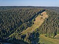
Seekopf with the giant slide in the Poppeltal district (aerial view)

Bannwald Bärlochkar
Once there planted since 1993 no tree or like and no dead wood was more removed, the Bärlochkar was on 7 November 1997 by a decree of the Forest Agency Karlsruhe protected forest explained. The karst landscape there was created during the Würm glacial period . The protected area is characterized by large storm thrown areas. So were alone in the field of forestry office Enzklösterle in 1999 when the hurricane Lothar 240,000 cubic meters of wood. On the storm thrown areas in Bärlochkar, the forest is now in the regeneration phase due to newly growing spruce, fir and beech trees. In the approx. 104 hectare forest reserve and total reserve Bärlochkar, the forest is left to its own devices like a primeval forest and only the educational trail leading through is kept free of fallen trees and broken branches. Information boards on the three-kilometer circular route convey knowledge about the forest, the local flora and fauna and the geological history of the landscape.

Information board for the circular route through the Bärlochkar

Primeval forest path through the Bärlochkar forest
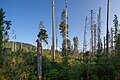
Natural regeneration on a storm thrown area in Bärlochkar


Enzquelle
The source of the Enz is set in stone in the middle of the Gompelscheuer district, below the historic forester's house, which is now privately owned and is now privately owned, which is located further up on the slope on a forest path, and which, together with the barn, is a listed building. The source of the Enz is also the starting point of the 115 km long Enztal cycle path , which accompanies the Enz to its confluence with the Neckar in Walheim .

Enzquelle in Gompelscheuer

Kaltenbachsee
The Kaltenbachsee, laid out in 1782 as a rafting lake, can be reached on foot from the Gompelscheuer district (starting point: Enzquelle) in just under an hour. The additional swell water required for rafting could be drained from the approx. 100 meter long and approx. 30 meter wide dammed lake on demand, in order to bring tree trunks tied together to rafts into the valley and further via Enz, Neckar and Rhine to the destination in the Netherlands . The original dam was mostly made of wood. It was not until 1813 that Karl August Friedrich Duttenhofer built the dam in its current form with the imposing passage made of stone and earth.

View from the dam over the Kaltenbachsee

The dam on the Kaltenbachsee, built in 1813


Deer enclosure
In the Hirschtal, which branches off to the west in Enzklösterle, there is a 3-hectare outdoor enclosure with red deer. The area, in which there are always 10-15 deer, can be circled on foot. A large number of information boards explain interesting facts about red deer and other native species.

Deer pack in the deer enclosure in Enzklösterle

Forest climbing garden
The Enzklösterle forest climbing garden, which is operated by CS Naturkonzepte, has been located in the Hirschtal valley since spring 2008 . At a height of four to 13 meters, over 30 elements can be climbed here. The Enzklösterle forest climbing garden is the first high ropes course in Germany to have created an altitude educational trail . This is a forest nature trail at a height of up to eight meters, the teaching platforms of which are connected by rope bridges.
Alpine skiing
With the large and small Hirschkopf lift, Enzklösterle has one of the longest ski slopes in the Black Forest (1,200 m).
Economy and Infrastructure
As a result of the nutrient-poor, acidic red sandstone soils, the cool, humid climate and the sometimes extremely steep slopes in the upper Enz Valley, agriculture was only possible on the limited areas of the valley floor. The last full-time farm gave up in the 1970s, and in 2005 the statistics named three part-time farms. In earlier times the population lived mainly from forestry, i. H. from logging, rafting , charcoal burning , resin extraction and the production of soot. Today tourism is the main source of income.
Water supply
The municipality of Enzklösterle receives its drinking water from the Black Forest Water Supply Association, of which it has been a member since 1996. With the accession, the municipal water extraction systems were handed over to the association. In 2001 the districts of Gompelscheuer and Poppeltal were connected to the drinking water supply of the Black Forest Water Supply Association.
Web links
Individual evidence
- ↑ State Statistical Office Baden-Württemberg - Population by nationality and gender on December 31, 2018 (CSV file) ( help on this ).
- ^ Website of the municipality of Enzklösterle: Information on the districts
- ^ The state of Baden-Württemberg. Official description by district and municipality. Volume V: Karlsruhe District Kohlhammer, Stuttgart 1976, ISBN 3-17-002542-2 . P. 515
- ↑ http://www.enzkloesterle.de/de/index.cfm?fuseaction=gemeindeleben&rubrik=gemeinderat
- ↑ http://www.krippena2000.de/krippen_figuren_start.html
- ↑ http://www.skizentrum-enzkloesterle.de/
- ^ Karl Walz, Dagmar Kraus: 100 years of drinking water. Black Forest Water Supply Association 1896–1996. Neuweiler 1996.

Altensteig | Althengstett | Bad Herrenalb | Bad Liebenzell | Bad Teinach-Zavelstein | Bad Wildbad | Calw | Dobel | Ebhausen | Egenhausen | Enzklösterle | Gechingen | Haiterbach | Höfen an der Enz | Nagold | Neubulach | Neuweiler | Oberreichenbach | Ostelsheim | Rohrdorf | Schömberg | Simmersfeld | Simmozheim | Unterreichenbach | Wildberg