
Erolzheim
| coat of arms | Germany map | |
|---|---|---|

|
Coordinates: 48 ° 5 ' N , 10 ° 4' E |
|
| Basic data | ||
| State : | Baden-Württemberg | |
| Administrative region : | Tübingen | |
| County : | Biberach | |
| Height : | 554 m above sea level NHN | |
| Area : | 26.31 km 2 | |
| Residents: | 3342 (Dec. 31, 2018) | |
| Population density : | 127 inhabitants per km 2 | |
| Postal code : | 88453 | |
| Area code : | 07354 | |
| License plate : | BC | |
| Community key : | 08 4 26 044 | |
| LOCODE : | DE RZH | |
| Community structure: | 4 districts | |
| Address of the municipal administration: |
Marktplatz 7 88453 Erolzheim |
|
| Website : | ||
| Mayor : | Jochen Ackermann | |
| Location of the municipality of Erolzheim in the Biberach district | ||
  |
||

Erolzheim is a municipality in the eastern district of Biberach in Upper Swabia . The community is located on the edge of the Illertal on the motorway slip road to the A 7 . Erolzheim is the seat of the municipal administration association Illertal and forms a sub-center with the neighboring Kirchdorf an der Iller .
geography
Geographical location
The place Erolzheim is on the western edge of the central Illertal. The municipal area extends from the middle of the Illertal to the neighboring Rottal. The suburbs of Bechtenrot and Edelbeuren are located there.
Community structure
The districts of Bechtenrot , Dietbruck , Edelbeuren and Erolzheim itself belong to the municipality of Erolzheim.
Neighboring communities
The municipality of Erolzheim borders on the following cities and municipalities: in the north on Kirchberg an der Iller and Gutenzell-Hürbel , in the east on Dettingen an der Iller and Kirchdorf an der Iller , in the south on Berkheim and in the west on the municipality Erlenmoos and the city of Ochsenhausen .
history

Erolzheim was on February 4, 1040 in one of Emperor Heinrich III. first mentioned on the Reichenau issued document, in which this confirmed the monastery Einsiedeln its possessions and rights to Erolzheim among others. From the 12th to the 16th century, the place was owned by the Lords of Erolzheim . In 1517, Emperor Maximilian granted the Lords of Erolzheim jurisdiction over the villages of Erolzheim and Kirchdorf an der Iller .

In 1594 the rule of Erolzheim was taken over by Konrad XI. von Bemmelberg (Bömmelberg), grandson of Konrad von Boyneburg , acquired. Erolzheim remained in the vicinity of the free imperial city of Memmingen as well as the spiritual territories of the imperial abbeys Rot an der Rot and Ochsenhausen until the Reichsdeputationshauptschluss 1803 imperial territory of the barons of Boyneburg-Bömmelberg . In 1806 the rule was mediatized and came to the Kingdom of Bavaria , in 1810 to the Kingdom of Württemberg . The Bömmelberg branch of the Hessian nobility dynasty Boyneburg expired in 1826 with the death of the baron Alois Sebastian von Bömmelberg, who also inherited the Westphalian castles of Gemen and Raesfeld , but sold them while he was still alive. His only surviving daughter died in 1831.
The reign of Erolzheim, which immediately became a fief when the last owner died in 1826, went to Heinrich von Kiesow from Augsburg for 200,000 florins and in 1830 to his nephew Friedrich von Bernhard . After the death of his first wife, Friedrich von Bernhard sold the Erolzheim allodial property with the exception of the family grave in 1839 to the royal Württemberg state finance administration. The next owner was the banker Osidor Obermayer from Augsburg. After his death in 1862, the manor passed to his children, the consul Karl Obermayer in Augsburg and Henriette, the wife of the Cologne banker Simon Oppenheim . In 1875, Karl von Obermayer, Colonel of the Bavarian Landwehr, sold the castle property to his former clerk Karl Enslin. In 1915, the privy councilor Albert Konstantin von Kienlin, who came from Ulm, acquired the Erolzheim castle and manor. In 1987 the von Kienlin family sold the castle and renovated it from 1993 to 1995. Today the castle houses around 30 apartments, offices and a hotel with a restaurant.
The main occupation in Erolzheim was shaped by agriculture for years. Cattle and grocer markets were held in Erolzheim. From 1842 a regular fruit market was held in the Schranne on the market square, which still exists today. At the end of the 19th century there were over 150 traders in Erolzheim. To this day, Erolzheim in the Illertal is the main place for shopping and services.
Religions
In Erolzheim the Roman Catholic parish belongs to the pastoral care unit Iller. The Protestant parish of Erolzheim-Rot is also represented.
Population development
- 1871: 1352 inhabitants
- 1983: 2006 inhabitants
- 1991: 2586 inhabitants
- 1995: 2856 inhabitants
- 2005: 3119 inhabitants
- 2010: 3185 inhabitants
- 2015: 3287 inhabitants
politics
Municipal council
The local elections on May 26, 2019 led to the following preliminary final result. The turnout was 61.0%.
| Political party | Proportion of (%) | Seats |
|---|---|---|
| Free electoral association | 52.6% | 7 seats |
| Independent citizens | 47.4% | 7 seats |
mayor
- Jochen Ackermann since 2010
- Günther Matheis 1970 to 2010
coat of arms
White wagon wheel with eight spokes on a black background.
Culture and sights
Buildings
- in Erolzheim
- The Catholic “Parish Church of St. Martin” was built in 1874/75 in neo-Gothic style according to plans by the architect Friedrich von Schmidt . It has a late Gothic tower basement from the 15th century.
- The mountain chapel "Maria im Busch" was built in 1670 for pilgrims on the Way of St. James and expanded in 1842/43.
- The "Wendelinuskappele" stands in the center of Erolzheim as another Catholic chapel in the area.
- The Erolzheim Palace with its park forms, alongside the town hall and market square, another historical center of the village.
- in districts
- The chapel “St. Sebastian and Margareta ”in Edelbeuren
- The Castle Edelbeuren in Edelbeuren.
- The chapel “St. Vitus ” in Bechten red
- The Harder-Funk grinding and oil mill from 1300 in the Bechtenrot district was owned by the Ochsenhausen Benedictine monastery . It is located on Mühlenstraße Oberschwaben .

Parish Church of St. Martin
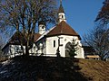
Mountain chapel "Maria im Busch" (Marienkapelle)

Wendelinus Chapel

Chapel in Edelbeuren

St. Vitus Chapel Berchtenrot
b.jpg)


.jpg)
.JPG)
Frohbergberglinde natural monument

Also St. Nicholas Linde ⊙ called Winter Linde is slightly below the Lady Chapel on the slopes of Mount Glad, who was called in earlier times Chapel Hill. The age of the gnarled tree veteran is estimated to be around 600 years. The tree monument, designated as a natural monument and entered in the list of distinctive and old tree specimens , was described as an ancient tree ruin in the Swabian Tree Book of 1911. At that time, the trunk of the linden tree was completely hollow and partially open. The outer shell of the trunk was 8.55 m in circumference at that time. Through various adhesions and the new formation of adventitious roots, which have developed over the course of the following decades, the linden has filled the cavity itself again. However, the earlier, outer tree cover with the old bark has gradually flaked off. Remnants of the original bark can only be seen at the upper end of the trunk. Otherwise, the wood structures that have grown back inside form the trunk that can be seen today. The former, mighty crown has also disappeared. Only three weaker branches that are still sprouting form today's rather lean crown. According to a measurement in 2014, the remaining trunk fragment still had a circumference of 6.05 m. The tree height for this point in time is given as approx. 21 m.
Economy and Infrastructure
traffic
Erolzheim is located at the intersection of the L 260 and L 299 state roads. The latter provides the connection to the A 7 (Ulm - Memmingen) three kilometers away. The nearest train station is in Kellmünz, six kilometers away, on the Neu-Ulm – Kempten railway line . There are also bus routes from Erolzheim to Biberach an der Riss , Ochsenhausen , Memmingen , Illertissen and to the Kellmünz train station.
Established businesses
The head office of the former Raiffeisenbank Illertal was located in Erolzheim until the merger with Volksbank Laupheim . Several small, medium-sized companies have their headquarters in the Erolzheim industrial area.
Public facilities
- Indoor swimming pool
- Community library
Health and care facilities
- Senior Center Erolzheim (42 care places)
Educational institutions
Erolzheim has a primary school and a secondary school , both of which are municipalities. There is also a kindergarten sponsored by the Roman Catholic parish and, since 2007, a forest kindergarten sponsored by the Erolzheimer Waldkindergarten Hollerbusch e. V. In addition, the Illertal Adult Education Center is based in Erolzheim.
.jpg)
Leisure and sports facilities
- Indoor swimming pool
- Festival hall
- Gym
- Reichenbachweiher forest pool
- Signposted cycling and hiking trails
- Sports fields
Sons and daughters of the church
- Willebold Held, Imperial Abbot of Rot an der Rot
- Karl Zenger (1838–1905), architect
- Erwin Biber (1905–1944), known as the racing driver Biberle
- Johannes Hösle (1929–2017), Romance studies and literary scholar
- Max-Engelhardt von Kienlin (* 1934), farmer, forester, mountaineer and author
- Konstantin Maier (* 1949), Roman Catholic clergyman and church historian
- Stefan Speth (* 1971), film architect, concept designer Blade Runner 2049 ; The Martian ; Cloud atlas ;
- Konstantin Gropper (* 1982), head of the music project Get Well Soon ; grew up in Erolzheim

Lookout at the chapel

Mountain chapel

Erolzheim Church

Erolzheim Castle


literature
- Johann Daniel Georg von Memminger: Description of the Oberamt Biberach . Cotta, Stuttgart and Tübingen 1837 ( full text at Wikisource )
- Kurt Diemer u. a .: Erolzheim - a market town in the Illertal. Anton H. Konrad Verlag, 1990.
- Swabian tree book . Edited by the Kgl. Württ. Forest Directorate Stuttgart. Verlag Strecker & Schröder, 1911. p. 89.
Web links
Individual evidence
- ↑ State Statistical Office Baden-Württemberg - Population by nationality and gender on December 31, 2018 (CSV file) ( help on this ).
- ↑ "Mahl- und Ölmühle Harder-Funk Bechtenrot" mill overview, at www.muehlenstrasse-oberschwaben.de
- ↑ "St. Nikolaus-Linde in Erolzheim" in the tree register, at www.baumkunde.de
- ^ "Summer lime tree 'Berglinde' on the Kapellenberg in Erolzheim" in Monumental Trees at monumentaltrees.com

Achstetten | Alleshausen | Allmannsweiler | Altheim | Attenweiler | Bad Buchau | Bad Schussenried | Berkheim | Betzenweiler | Biberach an der Riss | Castles | Dettingen on the Iller | Dürmentingen | Dürnau | Eberhardzell | Erlenmoos | Erolzheim | Ertingen | Gutenzell-Hürbel | Hochdorf | Ingoldingen | Kanzach | Kirchberg an der Iller | Kirchdorf an der Iller | Langenenslingen | Laupheim | Maselheim | Mietingen | Mittelbiberach | Moosburg | Ochsenhausen | Oggelshausen | Riedlingen | Red on the red | Schemmerhofen | Schwendi | Seekirch | Steinhausen an der Rottum | Tannheim | Tiefenbach | Ummendorf | Unlingen | Uttenweiler | Wain | Warthausen