
Kirchdorf an der Iller
| coat of arms | Germany map | |
|---|---|---|

|
Coordinates: 48 ° 5 ' N , 10 ° 8' E |
|
| Basic data | ||
| State : | Baden-Württemberg | |
| Administrative region : | Tübingen | |
| County : | Biberach | |
| Height : | 551 m above sea level NHN | |
| Area : | 22.86 km 2 | |
| Residents: | 3757 (December 31, 2018) | |
| Population density : | 164 inhabitants per km 2 | |
| Postal code : | 88457 | |
| Area code : | 07354 | |
| License plate : | BC | |
| Community key : | 08 4 26 066 | |
| Address of the municipal administration: |
Rathausstrasse 11 88457 Kirchdorf an der Iller |
|
| Website : | ||
| Mayor : | Rainer Langenbacher | |
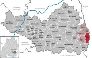
| Location of the municipality of Kirchdorf an der Iller in the Biberach district | ||
  |
||


Kirchdorf an der Iller is a municipality in the eastern district of Biberach in Baden-Württemberg . It is part of the Illertal municipal administration association and forms a sub-center with neighboring Erolzheim . The main factory of the Liebherr company is located in Kirchdorf .
geography
Geographical location
The Upper Swabian municipality of Kirchdorf belongs to the Donau-Iller region and is located in the Illertal . In the east, Kirchdorf borders on the Iller and thus on the state border with the Bavarian administrative district of Swabia . Kirchdorf is located about 15 kilometers north of Memmingen and about 32 kilometers east of the district town of Biberach .
Community structure
The districts belong to Kirchdorf:
- Church Village
- Oberopfingen
- Unteropfingen
and the living spaces
- Binnrot
- Rudeshof
- St. Angelus
- Schifferhaus
- Waldenhofen
- Wiesbauer.
The hamlets of Binnrot and Waldenhofen are special because they have no spatial connection with the municipality of Kirchdorf and are therefore exclaves in the municipal areas of Berkheim and Erolzheim.
Neighboring communities
The municipality of Kirchdorf an der Iller borders on the following municipalities: in the north on Dettingen an der Iller , in the east on the municipalities of Pleß , Fellheim and Heimertingen belonging to the Bavarian district of Unterallgäu , in the south on Tannheim and in the west on Berkheim and Erolzheim .
history
Kirchdorf was first mentioned in 764 in the deed of foundation for the Ottobeuren monastery . It belonged to the Kellmünz rule , but fell to the County of Bregenz around the year 1000 and to the Count Palatine of Tübingen in 1150 . The latter sold the place in 1342 to the Counts of Württemberg . In 1604 the Premonstratensian monastery Rot an der Rot acquired the place. When the ecclesiastical manors were abolished in the course of secularization in 1803, Kirchdorf came to the Kingdom of Württemberg . There it initially belonged to the Oberamt Leutkirch and came with the district reform in 1938 to the district of Biberach . Industrialization began in the 1920s with the construction of the Illerkraftwerk, the breakthrough came with the establishment of the Liebherr plant in 1949. With this construction, the place became one of the most important industrial locations in the Biberach district.
Religions
There is a Roman Catholic parish each in Kirchdorf and Oberopfingen . In the meantime there is also a Protestant and a New Apostolic congregation in the main town . In Kirchdorf there is also a Turkish-Islamic Association and a prayer room.
Incorporations


- 1842: Unteropfingen
- 1974: Oberopfingen


Population development
- 1949: 700 inhabitants
- 1961: 1623 inhabitants, 323 of them in Oberopfingen
- 1970: 1886 inhabitants, 347 of them in Oberopfingen
- 1991: 2782 inhabitants
- 1995: 3215 inhabitants
- 2005: 3594 inhabitants
- 2010: 3470 inhabitants
- 2015: 3516 inhabitants
coat of arms

The Kirchdorf coat of arms shows in a split shield in front two crossed burning red candles in gold, and in the back a gold three-legged flag in red.
Culture and sights
The grave of the baroque poet Andreas Speyer is in Kirchdorf .
Buildings

Roman Catholic parish church of St. Blasius from the year 764 AD. One of the oldest churches in the central Illertal.
- Dr. Hans Liebherr Stadium
- Kirchdorf outdoor pool
- The skyscraper
- Brother Klaus Chapel in the Binnrot exclave
- Ried chapel in Unteropfingen
Regular events
- Garden festival Oberopfingen
- Wine festival of the music association
- Evening serenade of the Musikverein in the Bürgerpark
- Christmas market in the Bürgerpark
Museums
- Michael von Jung memorial
Leisure and sports facilities
The range of leisure and sports facilities in Kirchdorf is diverse. The largest sports facility is the Dr. Hans Liebherr Stadium , built in 1972, with 600 seats. There are also tennis and soccer fields, a large heated outdoor pool with a double diving tower and a water slide, a hard court with basketball hoops, a community park with a skater facility, a chess field and the over 4-meter-high Dr.-Hans-Liebherr- Fountain. There is a swimming lake in Oberopfingen .
sports clubs
Kirchdorf has over 30 clubs. The largest is the Kirchdorf sports club, which has football, gymnastics, cycling, athletics, tennis and table tennis departments. The association, founded in 1929, has 1,100 members.
Economy and Infrastructure

The Liebherr company was founded in Kirchdorf an der Iller in 1949 . Hans Liebherr built his first product here, a tower crane that was mobile, easy to dismantle and reassemble. The typical yellow cranes from the Liebherr brand can still be found on many construction sites around the world.
traffic
The federal motorway 7 passes Kirchdorf and can be reached via the Dettingen an der Iller and Berkheim junctions . The nearest airport is in Memmingen . The next train station is Kellmünz , the next long-distance train station with IC stop is the nearby Memmingen train station .
Established businesses
- The Liebherr hydraulic excavators GmbH in Kirchdorf some 1,500 jobs is the largest employer in the vicinity. It was here that Hans Liebherr developed the first TK 10 tower crane in 1949 . All new products since the TK 10 tower crane , with the exception of the aerospace technology division, were initially developed and produced in Kirchdorf.
Educational institutions
With the Michael von Jung School, Kirchdorf has a primary and community school. There are also kindergartens in Kirchdorf and Oberopfingen .
Personalities
- Michael von Jung (1781–1858), pastor and poet
- Ernst Otto Fick (1898–1945), SS Brigade Leader and Major General of the Waffen SS
- Clemens Härle , master brewer and company founder
Honorary citizen
- Hans Liebherr (1915–1993), founder of Liebherr
- Paul Harrer († 1973), former pastor of Kirchdorf
- Harald Notz, Mayor of Kirchdorf from 1966 to 1995
- Hermann Hummel, Rector at the Michael-von-Jung-Schule 1984-2001 and deputy. Mayor 1980–1999
Web links
Individual evidence
- ↑ State Statistical Office Baden-Württemberg - Population by nationality and gender on December 31, 2018 (CSV file) ( help on this ).
- ^ Federal Statistical Office (ed.): Historical municipality directory for the Federal Republic of Germany. Name, border and key number changes in municipalities, counties and administrative districts from May 27, 1970 to December 31, 1982 . W. Kohlhammer, Stuttgart / Mainz 1983, ISBN 3-17-003263-1 , p. 545 .
Inner red | Oberopfingen | Rudeshof | Schifferhaus | St. Angelus | St. Gallus | Unteropfingen | Waldenhofen | Wiesbauer

Achstetten | Alleshausen | Allmannsweiler | Altheim | Attenweiler | Bad Buchau | Bad Schussenried | Berkheim | Betzenweiler | Biberach an der Riss | Castles | Dettingen on the Iller | Dürmentingen | Dürnau | Eberhardzell | Erlenmoos | Erolzheim | Ertingen | Gutenzell-Hürbel | Hochdorf | Ingoldingen | Kanzach | Kirchberg an der Iller | Kirchdorf an der Iller | Langenenslingen | Laupheim | Maselheim | Mietingen | Mittelbiberach | Moosburg | Ochsenhausen | Oggelshausen | Riedlingen | Red on the red | Schemmerhofen | Schwendi | Seekirch | Steinhausen an der Rottum | Tannheim | Tiefenbach | Ummendorf | Unlingen | Uttenweiler | Wain | Warthausen