Unteropfingen
|
Unteropfingen
Kirchdorf an der Iller parish
Coordinates: 48 ° 3 ′ 29 ″ N , 10 ° 7 ′ 40 ″ E
|
|
|---|---|
| Height : | 560 m above sea level NN |
| Residents : | 375 (2011) |
| Incorporation : | 1842 |
| Postal code : | 88457 |
| Area code : | 07354 |
Unteropfingen is one of three suburbs in the municipality of Kirchdorf an der Iller in the Biberach district in Upper Swabia .
history
The community is located on the Iller , which bounded the earlier Danube-Iller-Rhein-Limes until the 5th century . To the south the place has a common border with Oberopfingen , to the west with Berkheim and Erolzheim . To the east, Unteropfingen borders on Heimertingen and Fellheim in the Unterallgäu district .
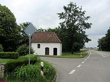
At the entrance to Unteropfingen, coming south of Oberopfingen, there is the path chapel dedicated to Saint Otmar of St. Gallen . A deed of donation records a knight Werner von Erolzheim around 1316, who donated the chapel to the later imperial abbey of Ochsenhausen . Other sources speak of a reed chapel. In fact, before the Illerkanal was built, the western part of the Unteropfingen north of Oberopfingen was a reed landscape .
Buildings
In 1612 it is noted in the archives that the then Prince-Bishop of Constance Jakob IV. Fugger , a descendant of Jakob Fugger the Rich, consecrated the St. Johann Baptist chapel, which is now in the center of the village. The reed chapel had become too small for the growing place. In the Thirty Years War, the place was devastated by both warring parties. The deconsecrated church was rededicated in 1656. In 1723 the chapel was renovated, enlarged and a tower was added.
The communal political connection to the municipality of Kirchdorf took place in 1842.
