
Dornhan
| coat of arms | Germany map | |
|---|---|---|

|
Coordinates: 48 ° 21 ' N , 8 ° 31' E |
|
| Basic data | ||
| State : | Baden-Württemberg | |
| Administrative region : | Freiburg | |
| County : | Rottweil | |
| Height : | 642 m above sea level NHN | |
| Area : | 44.92 km 2 | |
| Residents: | 6006 (December 31, 2018) | |
| Population density : | 134 inhabitants per km 2 | |
| Postal code : | 72175 | |
| Primaries : | 07455, 07423 | |
| License plate : | RW | |
| Community key : | 08 3 25 012 | |
| LOCODE : | DE DNW | |
| City structure: | 8 districts | |
City administration address : |
Obere Torstrasse 2 72175 Dornhan |
|
| Website : | ||
| Mayor : | Markus Huber | |
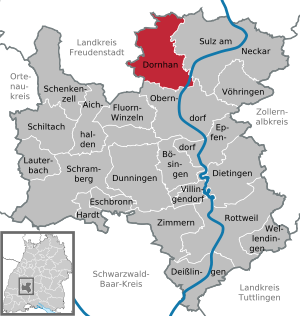
| Location of the city of Dornhan in the Rottweil district | ||
  |
||

Dornhan [ ˈdɔrnhaːn ] is a small town in the district of Rottweil in Baden-Württemberg in Germany .
geography
location
Dornhan lies on a plateau in the Black Forest foothills above the Neckar and Glatt valleys . Closest larger cities are Freudenstadt in the northwest, Rottweil and Oberndorf am Neckar in the southeast and Horb am Neckar in the northeast. The urban area is 450 to 685 m above sea level. NN .
Neighboring communities
Dornhan borders in the east on Sulz am Neckar , in the south on Oberndorf (both districts of Rottweil), in the west on Alpirsbach and Loßburg and in the north on Glatten and Schopfloch (all districts of Freudenstadt )
City structure
The city of Dornhan with the districts of Bettenhausen , Busenweiler, Dornhan, Fürnsal , Leinstetten, Marschalkenzimmern and Weiden also includes 15 villages, hamlets, farms and houses in addition to the city of Dornhan. The Busenweiler district includes the village of Busenweiler and the hamlet of Aischfeld. The Dornhan district includes the town of Dornhan, the hamlets Dobel and Gundelshausen, the Friedrichshof and Oberhart farms and the Brandeck and Braunhalden residential areas. The Fürnsal district includes the Fürnsal village and the Fürnsaler Sägmühle residential area. The Leinstetten district includes the village of Leinstetten and the hamlet of Kaltenhof. The districts of Bettenhausen, Marschalkenzimmern and Weiden only include the villages of the same name. In the district Dornhan lying Outbound Castle Brandeck , in the district Leinstetten the castle ruin Lichtenfels .
history

The city of Dornhan was first mentioned in a document as "Turnheim" in 777. The exact time when it became a city is unknown, but it is certain that the place has been known as "civitas" (city) since 1276.
The city of Dornhan originally belonged to the Counts of Sulz . In 1095 the Alpirsbach monastery received goods located in Dornhan as a gift. In the course of time the monastery gained more and more influence in Dornhan and maintained a nursing home to manage the property. The abbot of the Alpirsbach monastery had a court held in Dornhan three times a year, chairing it either personally and through a deputy. However, the monastery was only responsible for cases with lower jurisdiction ; the dukes of Teck , who owned the hereditary bailiwick of the monastery, were responsible for blood jurisdiction. Because of his high debts, Duke Friedrich von Teck ceded bailiwick rights to Count Eberhard the Greiner and thus to Württemberg in 1380 . From that time on, a Württemberg mayor exercised the power of rule. With the Reformation of Alpirsbach Monastery in 1534, Dornhan finally fell to Württemberg and since then, as the Dornhan office, was the seat of a Württemberg bailiff until 1807.
In 1807 Dornhan came to the implementation of the new administrative structure in the Kingdom of Württemberg first to the Oberamt Sulz , 1808 to the Oberamt Alpirsbach and in 1810 again to the Oberamt Sulz.
During the administrative reform during the Nazi era in Württemberg , Dornhan came to the district of Horb in 1938 . After the Second World War, the city of Dornhan fell into the French occupation zone and thus came to the newly founded state of Württemberg-Hohenzollern in 1947 , which was incorporated into the state of Baden-Württemberg in 1952.
In 1973 the district reform took place in Baden-Württemberg , when Dornhan came to the Rottweil district.
The present city was re-formed on March 1, 1972 by the merger of the city of Dornhan with the communities of Bettenhausen, Fürnsal, Leinstetten and Marschalkenzimmern. On April 1, 1974, the previously independent municipality of Busenweiler was incorporated. Weiden was incorporated on January 1, 1975.
politics

Municipal council
The local elections on May 26, 2019 brought the following result with a turnout of 61.6% (2014: 51.1%):
| Party / list | Share of votes | Seats | 2014 result | Result 2009 |
| Electoral Association | 63.6% | 12 (−1) | 66.1% | 63.3% |
| Citizen List | 36.4% | 7 (+1) | 33.9% | 36.7% |
mayor
On November 7, 2004, Markus Huber was elected mayor from February 1, 2005 with 74 percent of the votes. The previous incumbent Günter Woessner (1973-2005) did not run for the election. Wößner's predecessor was Erich Blocher.
The next mayoral election took place on November 11, 2012, in which Markus Huber was the only candidate to receive 98 percent of the vote and is thus mayor of the city of Dornhan for another term.
coat of arms
The blazon of the Dornhan coat of arms reads: "In gold on a black thorn branch, a red cock."
Until the incorporation, the other parts of the city also had their own coats of arms:
.png) In red, a silver (white) tawny owl sitting on a leafy silver (white) branch
 In blue a silver (white) house with a bell tower, at the top left a six-pointed silver (white) star
 Split shield, above in blue with three silver (white) stars, diagonal silver (white) stripes and below green |
 In a split shield above in silver (white) three green stemmed and green inseminated flowers of the flax plant next to each other, below a silver (white) zigzag bar in red
 In silver (white) on a green floor a black horse striding to the left
.png) A silver (white) willow with roots in red, the trunk of which is accompanied by two golden (yellow) roses |
Town twinning
Dornhan has maintained a partnership with the French community of Pont-de-Vaux in the Auvergne-Rhône-Alpes region since 1994 .
Culture and sights
Buildings


In the Zitzmannsbrunnenbachtal (also called Bettenhauser Tal) between Dornhan and Bettenhausen there is the so-called Wasserhäusle, a completely preserved pumping station from 1889 that was the origin and part of the Dornhan water supply.
In Bettenhausen , the image of the risen Christ can also be seen in the Church of St. Konrad, donated by Hans Marx von Bubenhofen in 1596. The alliance coat of arms of the donor couple and the coat of arms of the ancestors provide the framework for the painting.
At the community district are the ruins of the castle Lichtenfels , the castle Brandeck , the castle Leinstetten and from the castle Leinstetten Tower Hill received with basements.
In Leinstetten, the minstrel memorial commemorates Count Albrecht von Hohenberg (Haigerloch), who fell in the Battle of Leinstetten on April 17, 1298. Albrecht von Hohenberg is shown fighting in the Codex Manesse . There the only two stanzas that he has received are preserved. The burial place for Count Albrecht II von Hohenberg and his second wife Margareta von Fürstenberg is in the Kirchberg monastery near Sulz am Neckar .
In the district of Weiden there is a church from the 15th century and the house where Hermann Römpps was born, as well as the primary school, which is over 100 years old.
Economy and Infrastructure
education
There is a primary and secondary school in the Dornhans school center . There is a primary school each in the districts of Leinstetten, Marschalkenzimmern and Weiden. Gymnasiums and secondary schools exist in the nearby towns of Oberndorf and Sulz.
Electricity supply
In the district of Bettenhausen in Glatttal there is a hydropower plant fed from the Heimbach reservoir near Loßburg-Sterneck , which was originally also operated as a pumped storage power plant.
Personalities
sons and daughters of the town
- Johann Gottlob Christoph von Seeger (1767–1835), Württemberg senior bailiff, member of the state parliament
- Friedrich August Köhler (1768–1844), pastor in Marschalkenzimmern, author of topographical-historical writings
- Wilhelm Friedrich Wagner (1802–1882), wholesale merchant in Odessa
- Edmund von Sigel (1805–1866), Protestant theologian, general superintendent of Heilbronn
- John Buehler , formerly Johann Bühler (1831–1899), director of the Chicago State Bank and Senator for the State of Illinois
- Hans Holzwarth (1877–1953), gas turbine inventor
- Hermann Römpp (1901–1964), born in the Weiden district, chemist and scientific author
- Anton Reinhardt (1927–1945), born in Weiden, victim of the Nazi regime
- Klaus Graf (* 1969), racing driver
literature
- Horst-Herbert Grözinger: Dornhan - my home in the Black Forest. For the 25th anniversary of MADO - Maschinenfabrik Dornhan GmbH . Dornhan 1985.
- Wilhelm Ziegler: 25 years of the Dornhan Tennis Club: August 18-20, 1989 . Dornhan 1989.
- Ingrid Schatz: Gundelshausen, Busenweiler, Fürnsal. A journey through the past . Geiger, Horb am Neckar 1993.
- Gerda Wittmann-Zimmer: Dornhan ninety-nine zero-zero . Roseni, Hamm 2001.
- Franz Mögle-Hofacker: Repertories: Holdings H; 101.15 Secular stock books: OA Dornhan: (1471) 1527–1806 (1833) . Main State Archives, Stuttgart 2005.
- Hans Frieder Breymayer: Dornhan sermons . Ed .: Gerd Fischer. Fischbach Verlag, Dornhan 2007, ISBN 978-3-932904-14-1 .
- Casimir Bumiller (ed.): Dornhan. History of the area between Neckar, Glatt and Heimbach . Dornhan 2010. (695 pages)
swell
- Rüth, Bernhard (Ed.): Friedrich August Köhler. City and office of Dornhan. A historical description from 1839 (Documenta Suevia Vol. 12), Konstanz 2006.
Web links
Individual evidence
- ↑ State Statistical Office Baden-Württemberg - Population by nationality and gender on December 31, 2018 (CSV file) ( help on this ).
- ^ The state of Baden-Württemberg. Official description by district and municipality. Volume VI: Freiburg region Kohlhammer, Stuttgart 1982, ISBN 3-17-007174-2 . Pp. 467-471
- ↑ a b c d e f Max Miller , Gerhard Taddey (ed.): Handbook of the historical sites of Germany Vol. 6, Baden-Württemberg (= Kröner's pocket edition. Vol. 276). 2nd improved and expanded edition, Alfred Kröner Verlag, Stuttgart 1980, ISBN 3-520-27602-X , p. 151
- ^ Story of Dornhan Online at Leo BW
- ^ Federal Statistical Office (ed.): Historical municipality directory for the Federal Republic of Germany. Name, border and key number changes in municipalities, counties and administrative districts from May 27, 1970 to December 31, 1982 . W. Kohlhammer, Stuttgart / Mainz 1983, ISBN 3-17-003263-1 , p. 515 f. and 530 .
- ↑ Local council election Dornhan 2019. Retrieved on June 1, 2019 .
- ↑ crest descriptions on www.dornhan.de ( Memento of 16 April 2013, Internet Archive )
- ^ Anton Reinhardt

Aichhalden | Bösingen | Deißlingen | Dietingen | Dornhan | Dunningen | Epfendorf | Eschbronn | Fluorn tiny | Hardt | Lauterbach | Oberndorf am Neckar | Rottweil | Thigh Cell | Schiltach | Schramberg | Sulz am Neckar | Villingendorf | Voehringen | Shafts | Rooms above Rottweil