Voehringen (Württemberg)
| coat of arms | Germany map | |
|---|---|---|

|
Coordinates: 48 ° 20 ' N , 8 ° 40' E |
|
| Basic data | ||
| State : | Baden-Württemberg | |
| Administrative region : | Freiburg | |
| County : | Rottweil | |
| Height : | 506 m above sea level NHN | |
| Area : | 24.72 km 2 | |
| Residents: | 4335 (December 31, 2018) | |
| Population density : | 175 inhabitants per km 2 | |
| Postal code : | 72189 | |
| Area code : | 07454 | |
| License plate : | RW | |
| Community key : | 08 3 25 061 | |
| Address of the municipal administration: |
Sulzer Strasse 8 72189 Vöhringen |
|
| Website : | ||
| Mayor : | Stefan Hammer ( CDU ) | |
| Location of the municipality of Vöhringen in the Rottweil district | ||
Vöhringen is a municipality in the Rottweil district in Baden-Württemberg .
geography
location
Vöhringen is located on the eastern edge of the Middle Black Forest in the Korngäu , between 491 and 682 meters above sea level, five kilometers from Sulz am Neckar and twelve kilometers from Oberndorf am Neckar .
The next bigger cities are:
- Balingen , approx. 20 km
- Rottweil , approx. 25 km
- Horb am Neckar , approx. 25 km
- Herrenberg , approx. 40 km
- Tübingen , approx. 50 km
Neighboring communities
The municipality borders on Sulz am Neckar in the north, Rosenfeld ( Zollernalbkreis ) in the southeast and Oberndorf am Neckar in the southwest.
Community structure
The municipality of Vöhringen consists of the districts Vöhringen and Vöhringen-Wittershausen, both of which are spatially identical to the former communities of Vöhringen and Wittershausen. In the district of Vöhringen-Wittershausen, a village within the meaning of the Baden-Württemberg municipal code has been set up with its own local council and mayor as its chairman. The village has its own local administrative office under the name "Municipality of Vöhringen, local administration Wittershausen".
The Vöhringen district includes the village of Vöhringen, the Rötenmühle and Siegelhaus farms and the Ziegelhütte residential area. Only the village of Wittershausen belongs to the district of Vöhringen-Wittershausen. In the district of Vöhringen is the abandoned village of Beuren ( Beuren Castle ).
history
Voehringen
The Vöhringer mark is an ancient settlement area; proven to the Neolithic. After the Romans were driven out, the Alemanni took the land (indicated by the place name ending "ingen"). Vöhringen was first mentioned in 772 in a deed of donation from the Lorsch Codex . The dukes of Teck were the lords of the village . 1306 came the place to the county of Württemberg . Vöhringen belonged to the Oberamt Rosenfeld in the Duchy of Württemberg . At the beginning of the 19th century there were major territorial changes as a result of the Reichsdeputationshauptschluss . The associated upheavals were also the reason for a new administrative structure in the Kingdom of Württemberg, founded in 1806 . The Oberamt Rosenfeld was dissolved in 1808 and Vöhringen was assigned to the Oberamt Sulz . During the district reform during the Nazi era in Württemberg , Vöhringen came to the district of Horb in 1938 . In 1945 the place became part of the French occupation zone and thus came to the newly founded state of Württemberg-Hohenzollern , which was incorporated into the state of Baden-Württemberg in 1952. Through the district reform in Baden-Württemberg , Vöhringen came to the Rottweil district in 1973 .
The Vöhringer people have long been called Broatschuah (wide shoes ). According to a legend, an old Vöhringer trampled on a brood hen and its seven chicks .
Incorporations
On May 1, 1972, the previously independent community of Wittershausen was incorporated into Vöhringen. This had previously also belonged to the district of Horb and was first mentioned in a document in 1139 .
Religions
Vöhringen received its own parish in 1463, until then it had been a subsidiary of Bergfelden. The Reformation was introduced in Vöhringen and Wittershausen - as in all of Württemberg - in 1534. The place has been evangelical since then . Baptismal records have existed since 1584. The parishes in both suburbs belong to the Sulz am Neckar parish of the Evangelical Church in Württemberg . The few remaining adherents of the papacy are parish in the Roman Catholic community in Sulz am Neckar . The New Apostolic Church, on the other hand, has congregations in both suburbs.
politics
Administrative community
The community belongs to the agreed administrative community of the city of Sulz am Neckar.
Municipal council
The local election on May 25, 2014 in Vöhringen led to the following official final result. The turnout was 48.0% (2009: 54.9%). The municipal council consists of the elected voluntary councilors and the mayor as chairman. The mayor is entitled to vote in the municipal council.
| Free electoral association | 5 seats | 36.6% | 2009: 35.1% |
| Free citizens' association | 5 seats | 32.3% | 2009: 40.5% |
| CDU | 4 seats | 31.0% | 2009: 24.4% |
coat of arms
|
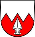
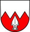
Blazon : "Divided from silver to red by a lace cut, the red field is covered with a fallen, silver ploughshare."
The coat of arms and flag were awarded by the Ministry of the Interior on August 13, 1975. |
|
| Justification of the coat of arms: The coat of arms originally used but not officially awarded showed a fallen iron-colored (blue) ploughshare in silver. The ploughshare probably goes back to a seal image from the early 19th century and appeared in the coat of arms in the mayor's office seals until the 1930s. In 1955, the municipality tried to have the coat of arms and flag officially awarded. On this occasion, the coat of arms was expanded to include the so-called Sulzer points in order to distinguish it from other ploughshare coats of arms. The Counts of Sulz are the oldest known local lords of Vöhringen. In 1095 they transferred their local property to the Alpirsbach monastery . |
Economy and Infrastructure
There are traditional, medium-sized companies in wood and plastic processing as well as hydrotechnology on site. Benefiting from the convenient location, some small industrial companies were able to settle here, in particular suppliers to the automotive industry and other metalworking companies, but also companies in the electronics and automation technology sectors. In addition, a large is truck stop with Flippothek in the industrial area "Ziegelhütte" at the highway exit.
traffic
The exit no. 32 "Sulz am Neckar" of the federal highway 81 ( Stuttgart - Singen ) is on the Vöhringer district.
The Stuttgart airport is about 40 minutes by car from the community.
education
In Vöhringen there is the Mühlbachschule, a primary and secondary school with a Werkrealschule and another primary school in the Wittershausen district. Realschulen and grammar schools are located in Sulz am Neckar and Horb am Neckar. There are also two communal and one Protestant kindergarten .
Personalities
- Johannes Binder (1858–1943), senior teacher, regional historian and local history researcher, author of the local chronicles of Vöhringen and Gebersheim near Leonberg as well as the home book for the Leonberg district.
- Dieter Kleinmann (* 1953), FDP politician, from 1996 to 2011 member of the state of Baden-Wuerttemberg, a member of the FDP / DVP - faction in the state parliament of Baden-Wuerttemberg, was a Protestant pastor in Wittershausen.
- Johannes Beilharz (* 1956), writer, poet, translator and painter
Web links
Individual evidence
- ↑ State Statistical Office Baden-Württemberg - Population by nationality and gender on December 31, 2018 (CSV file) ( help on this ).
- ↑ Main statute of the municipality of Vöhringen from March 22, 2005
- ^ The state of Baden-Württemberg. Official description by district and municipality. Volume VI: Freiburg region Kohlhammer, Stuttgart 1982, ISBN 3-17-007174-2 , pp. 518-519.
- ↑ Minst, Karl Josef [trans.]: Lorscher Codex (Volume 5), Certificate 3299, May 19, 772 - Reg. 751. In: Heidelberg historical stocks - digital. Heidelberg University Library, p. 145 , accessed on June 29, 2018 .
- ^ Federal Statistical Office (ed.): Historical municipality directory for the Federal Republic of Germany. Name, border and key number changes in municipalities, counties and administrative districts from May 27, 1970 to December 31, 1982 . W. Kohlhammer, Stuttgart / Mainz 1983, ISBN 3-17-003263-1 , p. 530 .
- ↑ Transcription of the oldest baptismal register of the evangelical parish of Vöhringen from 1584 to 1614: Uwe Heizmann: Transcription ( Memento of the original from May 13, 2016 in the Internet Archive ) Info: The archive link was inserted automatically and has not yet been checked. Please check the original and archive link according to the instructions and then remove this notice. . Baptismal register archived in the State Church Archive Stuttgart. Retrieved December 27, 2013.
- ↑ www.voehringen-bw.de - History: coat of arms of the municipality


