
Ramsen (Palatinate)
| coat of arms | Germany map | |
|---|---|---|

|
Coordinates: 49 ° 32 ' N , 8 ° 1' E |
|
| Basic data | ||
| State : | Rhineland-Palatinate | |
| County : | Donnersbergkreis | |
| Association municipality : | Eisenberg (Palatinate) | |
| Height : | 220 m above sea level NHN | |
| Area : | 27.08 km 2 | |
| Residents: | 1834 (Dec. 31, 2019) | |
| Population density : | 68 inhabitants per km 2 | |
| Postal code : | 67305 | |
| Area code : | 06351 | |
| License plate : | KIB, ROK | |
| Community key : | 07 3 33 060 | |
| Association administration address: | Hauptstrasse 86 67304 Eisenberg (Palatinate) |
|
| Website : | ||
| Local Mayor : | Arnold Ruster (FWG) | |
| Location of the local community Ramsen in the Donnersbergkreis | ||
  |
||


Ramsen ( Palatine : Ramse) is the most southerly local community in the Donnersbergkreis in Rhineland-Palatinate . It belongs to the Eisenberg (Palatinate) community , within which it is the smallest local community in terms of population.
geography
location
The community is located in the Palatinate Forest in its stump forest and forms the southern end of the Donnersbergkreis. In the south, the municipality borders on the Bad Dürkheim district and in the west on the Kaiserslautern district . Ramsen also includes the hamlets and residential areas Clauserhof, Gasthaus Forelle, Kisselhof, Kleehof , Neuhammer , Ripperterhof , Forsthaus Stumpfwald and Hof Walzwerk. Neighboring communities are - clockwise - Eisenberg (Pfalz) , Wattenheim , Enkenbach-Alsenborn and Kerzenheim .
Surveys
In the south of the district are the northern flank of the 444 m above sea level. NHN measuring Hohen Bühl on the border to Wattenheim and further northeast of the 379 m above sea level. NHN high Lerchenkopf and the 362 m above sea level. NHN high sand dump . Further west is the 397 m above sea level. NHN high ice head . In the far west on the border with Enkenbach-Alsenborn the 358 m above sea level extend . NHN high stone head and further south of 345 m above sea level. NHN high punch head . In the district triangle to Enkenbach-Alsenborn and Kerzenheim is the 353 m above sea level. NHN high Salweidenkopf . The Gänseberg also extends directly to the southwest of the settlement area and the Lehrberg to the west .
Waters
The Eisbach flows through Ramsen in a west-east direction ; its source streams - one of them is the Hollerbach - are on the parish of the municipality and flow together in the Eiswoog . It then takes on several tributaries such as the Bockbach , the Abttalbach and the Ellenbach .
Division of space

According to data from the Rhineland-Palatinate State Statistical Office, as of December 31, 2017.
climate
The annual precipitation is 730 mm. The precipitation is in the middle third of the values recorded in Germany. Lower values are registered at 47 percent of the German Weather Service's measuring stations . The driest month is January, with the most rainfall in May. In May there is 1.5 times more rainfall than in January. The precipitation hardly varies and is very evenly distributed over the year. Only eight percent of the measuring stations register lower seasonal fluctuations .
history
The community emerged in the Middle Ages from the Ramosa ad Ramesum monastery , which was founded there in 1146. In the middle of the stump forest between Ramsen and Neuhemsbach on the Enkenbach-Alsenborn district are the so-called nine stones , one of the three regional courts in the old Wormsgau , which are listed in the deed of feudal Prince Ruprecht III are mentioned by the Palatinate .
Until the end of the 18th century the place belonged to Nassau-Weilburg and its rule Kirchheim and Stauf as well as to the bishopric of Worms and was there under the Neuleiningen Episcopal Cellar .
From 1798 to 1814, when the Palatinate was part of the French Republic (until 1804) and then part of the Napoleonic Empire , Ramsen was incorporated into the canton of Göllheim and was the seat of its own mairie , which also included Stauf . In 1815 it was added to Austria . Just one year later, the place, like the entire Palatinate, changed to the Kingdom of Bavaria . From 1818 to 1862 Ramsen was part of the Kirchheim Land Commissioner - later Kirchhheimbolanden ; from this the district office of Kirchhheimbolanden emerged.
From 1939 the place was part of the Kirchheimbolanden district . After the Second World War , Ramsen became part of the then newly formed state of Rhineland-Palatinate within the French occupation zone . In the course of the first administrative reform in Rhineland-Palatinate , Ramsen moved to the newly formed Donnersbergkreis in 1969 ; three years later the community was incorporated into the also newly formed Eisenberg (Palatinate) community .
population
Population development
The development of the population of Ramsen, the values from 1871 to 1987 are based on censuses:
|
|
religion

The Evangelicals are part of the Protestant Church of the Palatinate and are subordinate to the Dean's Office Bad Dürkheim-Grünstadt. The Catholics belong to the diocese of Speyer and are subordinate to the dean's office in Bad Dürkheim . From the end of the 17th century Ramsen was looked after by the parish of Göllheim and from 1808 from Hettenleidelheim. Later the parish received a local parish. Since January 1, 2016, the Catholic Church has been a branch of the parish of St. Luke in Hettenleidelheim. The “Ramser Chapel” is also located on a hill. On October 31, 2014, 43 percent of the population were Protestant , just under 35 percent Roman Catholic and 20 percent non-denominational.
politics
Municipal council
The municipal council in Ramsen consists of 16 council members who were elected in a personalized proportional representation in the Rhineland-Palatinate municipal elections in 2019 , and the honorary local mayor as chairman.
The distribution of seats in the municipal council:
| choice | SPD | CDU | FWG | total |
|---|---|---|---|---|
| 2019 | 5 | 5 | 6th | 16 seats |
| 2014 | 5 | 6th | 5 | 16 seats |
| 2009 | 5 | 5 | 6th | 16 seats |
| 2004 | 3 | 3 | 10 | 16 seats |
- FWG = Free Voting Group of the Verbandsgemeinde Eisenberg (Pfalz) e. V.
mayor
The local mayor is Arnold Ruster (FWG). In a runoff election on June 16, 2019, he prevailed against the previous incumbent Wolfgang Steitz (CDU) with a share of the vote of 59.27 percent. His predecessors in office were Norbert Bayer (SPD) and, until 2009, Otto Frambach.
coat of arms
|
|
Blazon : “Divided by red and gold; above a golden crook crossed with a golden lance, covered with a silver shield, inside a red cross, below the red letter R. " |
Culture and sights
Cultural monuments

Catholic Church
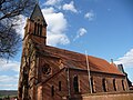
protestant church
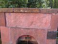
Fountain with a walled-in scratch relief "Whale spits out Jonas"; Early Romanesque or Roman-Early Christian relief


The cloister courtyard is designated as a monument zone .
There are also numerous individual monuments, including the Catholic parish church of the Assumption , which was built in the style of homeland security architecture, and the Gienanth dolls house ; The latter is located in the Seehaus Forelle restaurant on the Eiswoog.
nature
The largest part of the municipality marking is in the Palatinate Forest Nature Park , which in turn belongs to the Palatinate Forest-Vosges du Nord Biosphere Reserve . There are a total of four natural monuments within the municipality . In the south of the municipality is also the Ritterstein 287 ; it is called Eis-Ursprung and marks the source of the Eisbach.
regional customs
Every year on the third weekend in September the “Ramser Curb ” takes place. The festival traditionally begins with the solemn excavation of the Kerwe at the Kerwedenkmal by the “Kerweborsch”. On Sunday the Kerwe parade followed by a Kerwerede on the market square. On Tuesday night the Kerwe is buried with a speech.
The inhabitants of Ramsen are popularly referred to as "Ramser Wildsäue ". On the one hand the Kerwedenkmal, on which a wild boar sits enthroned, and on the other hand the market place, on which numerous wild boar sculptures can be found, reminds of this. The reason for this is presumably the adjacent stump forest, in which many wild boars live.
Economy and Infrastructure
economy
Formerly was mined locally iron. At least 18 large slag mounds from the first century exist on the parish landmarks.
Due to the geographic conditions, the forest and timber industry dominated the area for centuries. Since the late Middle Ages, Ramsen has had the right to purchase timber in the nearby stump forest . From the early modern period on there was a forestry office; The Donnersberg Forestry Office in Kirchheimbolanden is now responsible for the local forest areas.
traffic
_Bahnhof-_auf_Bahnsteig-_RB_628_289_11.7.2009.jpg)
-_Ripperterhof-_Ortseinfahrt_von_Ramsen_(Pfalz)_kommend_4.12.2010.JPG)
- rail
Ramsen received a rail connection in 1932 when the Eistalbahn , which had previously ended in Eisenberg and started in Grünstadt , was tied through to Enkenbach . A year later, the Eiswoog halt was built next to the local train station in the west of the district . The Eistal Viaduct , which was created west of the settlement area, is the longest railway bridge in the Palatinate. The east of the Stempelkopf tunnel , which the route crosses, is also on the Ramser district. In 1976 passenger traffic was discontinued, local freight traffic in 1981.
After passenger transport between Grünstadt and Eisenberg was reactivated in 1994, the section to Ramsen followed a year later; Since then, Ramsen has been the end of the line and is served by regional trains in regular intervals. On Sundays, the line has been extended beyond Ramsen to Eiswoog since 2001 . The public transport system is in the transport association Rhein-Neckar integrated (VRN), apply the Community tariffs.
- Street
The national road 395 leads east-west direction through the congregation. From this, the state road 396 branches off to Göllheim and the district road 74 , which leads to Hettenleidelheim on the other side of the district and becomes district road 35 there. The county road 81 connects the Ripperterhof to the road network. The A 63 in the north and the A 6 in the south are also located a short distance from the municipality .
tourism

The Stumpfwaldbahn , which has been operating since 1996, is a three-and-a-half kilometer long museum field railway that runs in the north of the Palatinate Forest in the district of Ramsen and is operated by the Stumpfwaldbahn Ramsen eV association. Your route begins on the western outskirts of Ramsen and ends at the Eiswoog reservoir.
Also is Ramsen on Barbarossa bike path , which in the western direction as far as Glan-Münchweiler leads and in the east to Worms and at marked with a blue bar Fernwanderweg Staudernheim-Soultz-sous-Forêts and one with a blue-red bar labeled Path that connects Kirchheimbolanden and Pirmasens . There is also a hiking trail through the municipality that is marked with a yellow bar and leads from Glanbrücken to Wachenheim an der Weinstrasse . In the far west, the Nahegau-Wasgau-Vosges long-distance hiking trail marked with a white cross leads over the municipal marker for a short stretch . In addition, the local section of the has Palatinate Forest Association , the cabin in the community forest , which is located in the west of the district.
Institutions

The Spatzennest , an evangelical institution for child and youth welfare, was located on site until 2007 ; In the mid-1990s it hit the headlines as part of the Worms trials . In addition, there is a primary school and a Catholic kindergarten in Ramsen.
Personalities
Sons and daughters of the church
- Heinrich Schumacher (1883–1949), Catholic priest, Vice Rector of the German National Foundation Santa Maria dell'Anima in Rome; from 1913 professor of theology and author at the Kath. University of Washington DC, USA.
- Theo Rörig (* 1940), sculptor
People who have worked in the community
- Albert Boßlet (1880–1957), German architect, builder of the Catholic Church of the Assumption of Mary in Ramsen (1910).
- Hanns Fay (1888–1957), German painter, created the mural in the Catholic Church in Ramsen.
- Johannes Kriebitzsch (1857–1938), painted the windows of the local Protestant church in 1907.
- Franz Schöberl (1845–1908), Austro-German architect, under whose direction the Protestant parish church in Ramsen was built in 1907.
literature
- Literature about Ramsen in the Rhineland-Palatinate State Bibliography
- Martin Mattheiss, overview of the history of Ramsen from 1146 to 1816 , in: Jöckle, Clemens / Witte, Dagmar: 850 years of Ramsen. Contributions to local history, Lingenfeld 1996; [1]
Web links
Individual evidence
- ↑ a b State Statistical Office of Rhineland-Palatinate - population status 2019, districts, municipalities, association communities ( help on this ).
- ↑ State Statistical Office Rhineland-Palatinate (ed.): Official directory of the municipalities and parts of the municipality. Status: January 2019 [ Version 2020 is available. ] . S. 89 f . (PDF; 3 MB).
- ↑ State Statistical Office, land use on December 31, 2017 for Ramsen. Retrieved June 15, 2019
- ↑ State Statistical Office Rhineland-Palatinate - regional data
- ^ The Regional Returning Officer Rhineland-Palatinate: Local elections 2019, city and municipal council elections
- ^ Marie-Luise Selzer: Runoff election in Ramsen: Arnold Ruster elected local mayor. News portal Eisenberg Aktuell of the Verbandsgemeinde Eisenberg (Pfalz), June 16, 2019, accessed on September 1, 2019 .
- ↑ Renate Müller-Krumbach: The dollhouse of the von Gienanth family . Wernersche Verlagsgesellschaft , Worms 2016, ISBN 978-3-88462-368-8 , p. 25 .
- ^ Dieter Krienke: Cultural monuments in Rhineland-Palatinate . tape 15 Donnersbergkreis. Wernersche Verlagsgesellschaft , Worms 1998, ISBN 978-3-88462-153-0 , p. 178 .
- ^ Ramsen - Stumpfwald - Eistalbahn and Court Square. Retrieved April 9, 2017 .
- ^ Friedrich Sprater: The Palatinate Industries in Prehistory and Early History (= local history publications of the Palatinate History Museum). Neustadt 1926, p. 7 ff.
- ↑ Ramsen - Catholic Church of the Assumption of Mary. In: donnersberg-touristik.de. Retrieved May 29, 2019 .
- ^ Ramsen - Protestant parish church. In: donnersberg-touristik.de. Retrieved May 29, 2019 .

Albisheim (Pfrimm) | Alsenz | Bayerfeld-Steckweiler | Bennhausen | Biedesheim | Bischheim | Bistiffer | Bolanden | Börrstadt | Breunigweiler | Bubenheim | Dannenfels | Dielkirchen | Dried mussel | Dreisen | Solitude | Eisenberg (Palatinate) | Falkenstein | Finkenbach-Gersweiler | Gauersheim | Gaugrehweiler | Gehrweiler | Gerbach | Göllheim | Gonbach | Gundersweiler | Höringen | Ilbesheim | Immesheim | Imsbach | Imsweiler | Jakobsweiler | Lime kiln | Katzenbach | Candle Home | Kirchheimbolanden | War field | Lautersheim | Pay field | Mannweiler-Cölln | Marnheim | Morschheim | Mörsfeld | Münchweiler an der Alsenz | Münsterappel | Niederhausen an der Appel | Niedermoschel | Oberhausen an der Appel | Upper Muschel | Oberndorf | Oberwiesen | Orbis | Ottersheim | Ramsen | Ransweiler | Rathskirchen | Reichsthal | Rittersheim | Rockenhausen | Ruppertsecken | Rüssingen | Saint Alban | Schiersfeld | Schönborn | Schweisweiler | Souls | Sippersfeld | Sitters | Stahlberg | Standenbühl | Steinbach am Donnersberg | Stetten | Teschenmoschel | Unkenbach | Waldgrehweiler | Wartenberg-Rohrbach | Weitersweiler | Winnweiler | Winterborn | Würzweiler | Zellertal