Bockbach (Eisbach)
| Bockbach | ||
|
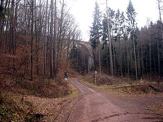
Bockbachbrücke of the Eistalbahn at the valley exit. View approximately to the southeast into the valley, in the foreground tracks of the Stumpfwaldbahn . |
||
| Data | ||
| Water code | DE : 2391814 | |
| location | Germany | |
| River system | Rhine | |
| Drain over | Eisbach → Rhine → North Sea | |
| source | almost 4 km south-southwest of Ramsen in the stump forest 49 ° 30 ′ 14 ″ N , 8 ° 0 ′ 6 ″ E |
|
| Source height | approx. 305 m above sea level NHN | |
| muzzle | at the Kleehof from the southeast and from the right in the upper Eisbach Coordinates: 49 ° 31 '40 " N , 7 ° 59' 24" E 49 ° 31 '40 " N , 7 ° 59' 24" E |
|
| Mouth height | 226 m above sea level NHN | |
| Height difference | approx. 79 m | |
| Bottom slope | approx. 24 ‰ | |
| length | 3.4 km | |
| Catchment area | 5.089 km² | |
The Bockbach is not quite 3.5 km forest creek in the northern Palatinate Forest , near the hamlet of Kleehof the municipality Ramsen in Donnersbergkreis ( Rhineland-Palatinate ) from the southeast coming from the right upper Eisbach tapers.
course
The Bockbach rises about 3.8 km south-south-west of the center of Ramsen in the eastern stump forest , roughly between the Hohe Bühl forest in the south-west and Sandhübel in the north-east, at about 305 m above sea level. NHN on the eastern slope of the 379 m high Lerchenkopf . The stream runs its first 400 m northeast until it has taken in two other source streams, each not much shorter at the confluence, and then turns on a north course. In the middle course it feeds three ponds one after the other over a distance of about 500 m. Soon after the last one, a creek about half a kilometer in length runs from the right at a little over 245 m . There the Bockbach bends to the northwest and maintains this direction on its last kilometer to the mouth. Shortly before this, a bridge of the Eistalbahn spans its valley, then it flows into the upper Eisbach about a quarter of a kilometer south of the Kleehof not far from the Bockswiese at about 226 m above sea level .
The Bockbach flows within the municipality of Ramsen and right up to the end in the forest. It is the first tributary of this size class that the Eisbach experiences. A forest path runs through most of the Bockbach valley, mainly on the lower left slope, sometimes on both sides; There are no public roads.
Attractions
The Bockbachbrücke of the Eistalbahn and the alternative station Bockbachtal of the Stumpfwaldbahn are known nationwide .
literature
- Topographic map 1: 25,000 Grünstadt and Leiningerland from the State Office for Surveying and Geographic Base Information Rhineland-Palatinate , 2003.
Individual evidence
- ↑ a b Map service of the landscape information system of the Rhineland-Palatinate Nature Conservation Administration (LANIS map) ( notes )
- ↑ a b GeoExplorer of the Rhineland-Palatinate Water Management Authority ( information )
