
Rehbach (near Sobernheim)
| coat of arms | Germany map | |
|---|---|---|

|
Coordinates: 49 ° 51 ' N , 7 ° 38' E |
|
| Basic data | ||
| State : | Rhineland-Palatinate | |
| County : | Bad Kreuznach | |
| Association municipality : | Nahe-Glan | |
| Height : | 336 m above sea level NHN | |
| Area : | 2.21 km 2 | |
| Residents: | 46 (Dec 31, 2019) | |
| Population density : | 21 inhabitants per km 2 | |
| Postal code : | 55566 | |
| Area code : | 06756 | |
| License plate : | KH | |
| Community key : | 07 1 33 082 | |
| Association administration address: | Marktplatz 11 55566 Bad Sobernheim |
|
| Website : | ||
| Local Mayor : | Reinhold Kessel | |
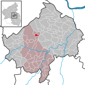
| Location of the local community Rehbach in the Bad Kreuznach district | ||
  |
||


Rehbach is a municipality in the Bad Kreuznach district in Rhineland-Palatinate . It belongs to the community of Nahe-Glan .
geography
Rehbach is located on the southern slope of a 400 m high hill in the Soonwald . The village is surrounded by fields, meadows and arable land. The closest cities are Bad Kreuznach in the east and Simmern in the northwest. Neighboring communities are Ippenschied , Winterburg , Bockenau , Daubach and the abandoned Eckweiler .
history
The present town of eleven properties, a new plant from 1972, because the old local situation because of aircraft noise and the risk of a plane crash in the flight path, of up to about 1960 by the US Air Force and then to 1997 by the Bundeswehr used Horse Field Airfield , had to be abandoned.
A memorial stone on the site of the old town indicates its 500-year history. Both the bell tower of the old parish hall and the village fountain were relocated to the new location. After the abandonment of the airfield in 1998, the local community of Rehbach, together with the city of Bad Sobernheim and the local community of Ippenschied, founded the "Planungsverband Konversions intended" horse field "in order to convert the area into civilian use.
Population development
The development of the population of Rehbach, the values from 1871 to 1987 are based on censuses:
|
|
politics
Municipal council
The municipal council in Rehbach consists of six council members, who were elected by a majority vote in the local elections on May 26, 2019 , and the honorary local mayor as chairman.
mayor
The local mayor is Reinhold Kessel. In the local elections on May 26, 2019, he was confirmed in his office with 96.88% of the votes.
coat of arms
|
|
Blazon : "A blue wave bar in red, covered with a silver, gold-horned roebuck." |
| Justification for the coat of arms: The wavy bar and the roebuck symbolize the place name. |
.
Economy and Infrastructure
The federal highways 41 and 50 are easily accessible and lead to a the Rhine-Main area with the Frankfurt airport and on the other to the Hunsrück located Frankfurt-Hahn Airport . In Bad Sobernheim (9 km away) there is a train station on the Bingen – Saarbrücken line .
Web links
- Local community Rehbach on the website of the Bad Sobernheim community association
- Local portrait from SWR television
- Literature about Rehbach in the Rhineland-Palatinate state bibliography
Individual evidence
- ↑ a b State Statistical Office of Rhineland-Palatinate - population status 2019, districts, municipalities, association communities ( help on this ).
- ↑ State Statistical Office Rhineland-Palatinate - regional data
- ^ The regional returning officer RLP: Municipal council election 2019 Rehbach. Retrieved September 19, 2019 .
- ^ The Regional Returning Officer RLP: direct elections 2019. see Bad Sobernheim, Verbandsgemeinde, 14th line of results. Retrieved September 19, 2019 .

Abtweiler | Allenfeld | Altenbamberg | Eagle swings | Floodplains | Bad Kreuznach | Bad Sobernheim | Bärenbach | Bärweiler | Becherbach | Becherbach near Kirn | Biebelsheim | Bockenau | Boos | Braunweiler | Brauweiler | Breitenheim | Bretzenheim | Bruschied | Burgsponheim | Callbach | Dalberg | Daubach | Daxweiler | Desloch | Dörrebach | Dorsheim | Duchroth | Eckenroth | Feilbingert | Frei-Laubersheim | Fürfeld | Gebroth | Guldental | Gutenberg | Hackenheim | Hahnenbach | Hallgarten | Hargesheim | Heimweiler | Heinzenberg | Hennweiler | Hergenfeld | Hochstätten | Hochstetten-Dhaun | Horbach | Hüffelsheim | Hundsbach | Ippenschied | Jeckenbach | Kellenbach | Kirn | Cherry red | Königsau | Langenlonsheim | Langenthal | Laubenheim | Listener | Lettweiler | Limbach | Löllbach | Almond | Martinstein | Meckenbach | Meddersheim | Meisenheim | Merxheim | Monzingen | Münchwald | New Bamberg | Niederhausen | Norheim | Walnut | Oberhausen an der Nahe | Oberhausen near Kirn | Oberstreit | Odernheim am Glan | Otzweiler | Pfaffen-Schwabenheim | Pleitersheim | Raumbach | Rehbach | Rehborn | Reiffelbach | Roth | Roxheim | Rudesheim | Rümmelsheim | Saint Catherine | Schloßböckelheim | Schmittweiler | Schneppenbach | Schöneberg | Black earth | Schweinschied | Schweppenhausen | Seesbach | Seibersbach | Simmertal | Summer slump | Spa bridges | Spall | Sponheim | Staudernheim | Stromberg | Tiefenthal | Traisen | Volxheim | Waldböckelheim | Waldlaubersheim | Wallhausen | Warmsroth | Hamlet near Monzingen | Weinsheim | Weitersborn | Windesheim | Winterbach | Winterburg