Tannay (Nièvre)
| Tannay | ||
|---|---|---|

|
|
|
| region | Bourgogne-Franche-Comté | |
| Department | Nièvre | |
| Arrondissement | Clamecy | |
| Canton | Clamecy | |
| Community association | Tannay-Brinon-Corbigny | |
| Coordinates | 47 ° 22 ′ N , 3 ° 36 ′ E | |
| height | 161-366 m | |
| surface | 15.36 km 2 | |
| Residents | 585 (January 1, 2017) | |
| Population density | 38 inhabitants / km 2 | |
| Post Code | 58190 | |
| INSEE code | 58286 | |
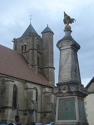
 Saint-Léger church |
||
Tannay is a French commune of 585 inhabitants (at January 1, 2017) in the department of Nièvre in the region of Bourgogne Franche-Comté . It belongs to the Arrondissement of Clamecy and the Canton of Clamecy .
geography
The municipality is located around 50 kilometers south of Auxerre on a hill above the valley of the River Yonne and on the parallel canal Canal du Nivernais . Neighboring municipalities are Amazy in the north, Metz-le-Comte in the northeast, Flez-Cuzy in the east, Saint-Didier in the southeast, Lys in the south, Talon in the southwest and Saint-Germain-des-Bois in the west.
Community partnerships
literature
- Le Patrimoine des Communes de la Nièvre. Volume 2, Flohic Editions, Charenton-le-Pont 1999, ISBN 2-84234-054-X , pp. 1023-1029.
Web links
Commons : Tannay - collection of images, videos and audio files
