
Menou
| Menou | ||
|---|---|---|
|
||
| region | Bourgogne-Franche-Comté | |
| Department | Nièvre | |
| Arrondissement | Clamecy | |
| Canton | Clamecy | |
| Community association | Haut Nivernais-Val d'Yonne | |
| Coordinates | 47 ° 22 ′ N , 3 ° 17 ′ E | |
| height | 179-362 m | |
| surface | 13.23 km 2 | |
| Residents | 181 (January 1, 2017) | |
| Population density | 14 inhabitants / km 2 | |
| Post Code | 58210 (previously: 58630) | |
| INSEE code | 58163 | |
 Town hall (Mairie) of Menou |
||

Menou is a French municipality with 181 inhabitants (at January 1, 2017) in the department of Nièvre in the region of Bourgogne Franche-Comté (before 2016 Bourgogne ). It belongs to the Arrondissement of Clamecy and the Canton of Clamecy (until 2015 Varzy ). The inhabitants are called Nantinivinois .
geography
Menou is about 50 kilometers north-northeast of Nevers . Neighboring municipalities of Menou are Menestreau in the north, La Chapelle-Saint-André in the east and northeast, Oudan in the east and southeast, Colméry in the south and west and Couloutre in the west and northwest.
Population development
| year | 1962 | 1968 | 1975 | 1982 | 1990 | 1999 | 2006 | 2011 | 2016 |
| Residents | 335 | 293 | 251 | 209 | 201 | 172 | 172 | 182 | 182 |
| Source: Cassini and INSEE | |||||||||
Attractions
- Saint-Siméon church
- Notre-Dame-de-la-Tete-Ronde chapel
- Menou Castle, built in 1672
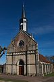
Saint-Siméon church

Notre-Dame-de-la-Tete-Ronde monastery
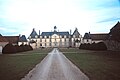
Menou Castle


literature
- Le Patrimoine des Communes de la Nièvre. Volume 2, Flohic Editions, Charenton-le-Pont 1999, ISBN 2-84234-054-X , pp. 1052-1054.
Web links
Commons : Menou - collection of images, videos and audio files