
La Chapelle-Saint-André
| La Chapelle-Saint-André | ||
|---|---|---|
|
||
| region | Bourgogne-Franche-Comté | |
| Department | Nièvre | |
| Arrondissement | Clamecy | |
| Canton | Clamecy | |
| Community association | Haut Nivernais-Val d'Yonne | |
| Coordinates | 47 ° 24 ' N , 3 ° 21' E | |
| height | 195-310 m | |
| surface | 27.15 km 2 | |
| Residents | 315 (January 1, 2017) | |
| Population density | 12 inhabitants / km 2 | |
| Post Code | 58210 | |
| INSEE code | 58058 | |
| Website | http://www.mairie-lachapellesaintandre.fr/ | |
 Town hall (Mairie) of La Chapelle-Saint-André |
||

La Chapelle-Saint-André is a French municipality with 315 inhabitants (as of January 1 2017) in the department of Nièvre in the region of Bourgogne Franche-Comté . It belongs to the Arrondissement of Clamecy and the Canton of Clamecy .
geography
La Chapelle-Saint-André is located about 47 kilometers south-southwest of Auxerre on the Sauzay River . Neighboring municipalities of La Chapelle-Saint-André are Corvol-l'Orgueilleux in the north and north-east, Courcelles in the east, Varzy in the east and south-east, Oudan in the south, Menou in the south-west, Menestreau in the west and Entrains-sur-Nohain in the north-west.
Population development
| year | 1962 | 1968 | 1975 | 1982 | 1990 | 1999 | 2006 | 2013 |
| Residents | 478 | 530 | 435 | 386 | 371 | 329 | 338 | 336 |
| Source: Cassini and INSEE | ||||||||
Attractions
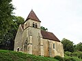
- Saint-André church
- Corbelin Castle, Monument historique since 1940
- Chapel of Corbelin

Saint-André church

Corbelin Castle
Chapel of Corbelin


literature
- Le Patrimoine des Communes de la Nièvre. Volume 2, Flohic Editions, Charenton-le-Pont 1999, ISBN 2-84234-054-X , pp. 1035-1037.
Web links
Commons : La Chapelle-Saint-André - Collection of images, videos and audio files