
Poor
| Poor | ||
|---|---|---|
.svg)
|
|
|
| region | Bourgogne-Franche-Comté | |
| Department | Nièvre | |
| Arrondissement | Clamecy | |
| Canton | Clamecy | |
| Community association | Haut Nivernais-Val d'Yonne | |
| Coordinates | 47 ° 28 ' N , 3 ° 33' E | |
| height | 147-252 m | |
| surface | 8.49 km 2 | |
| Residents | 283 (January 1, 2017) | |
| Population density | 33 inhabitants / km 2 | |
| Post Code | 58500 | |
| INSEE code | 58011 | |

Armes is a French municipality with 283 inhabitants (as of January 1 2017) in the department of Nièvre in the region of Bourgogne Franche-Comté . It belongs to the Arrondissement of Clamecy and the Canton of Clamecy .
geography
Armes is about 35 kilometers south of Auxerre . The Yonne forms the southwestern municipal boundary. Neighboring communities of Armes are Clamecy in the north and west, Lichères-sur-Yonne in the east and northeast, Dornecy in the southeast and Chevroches in the south.
Population development
| year | 1962 | 1968 | 1975 | 1982 | 1990 | 1999 | 2006 | 2013 |
| Residents | 315 | 307 | 325 | 293 | 244 | 279 | 287 | 303 |
| Source: Cassini and INSEE | ||||||||
Attractions
- Saint-Maurice church from the 19th century
- Saint-Lazare Chapel, Monument historique
- Les Terrasses castle from the 14th century
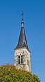
Saint-Maurice Church

Saint-Lazare chapel
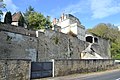
Les Terrasses Castle


Personalities
- Vladimir Dimitrijević (1934–2011), Serbian publisher and writer, killed in Armes in a traffic accident
literature
- Le Patrimoine des Communes de la Nièvre. Volume 1, Flohic Editions, Charenton-le-Pont 1999, ISBN 2-84234-054-X , pp. 249-250.
Web links
Commons : Armes (Nièvre) - Collection of images, videos and audio files