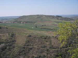
Gangelsberg
| Gangelsberg | ||
|---|---|---|
|
View to the Gangelsberg |
||
| height | 340 m above sea level NN | |
| location | Rhineland-Palatinate , Germany | |
| Coordinates | 49 ° 47 '33 " N , 7 ° 44' 11" E | |
|
|
||
The Gangelsberg is a 340 m high mountain in the Nahe valley near Bad Kreuznach .
history
From 1813 to 1814 there was a station of the optical telegraph line Metz – Mainz on the Gangelsberg . The Kinnsfelstunnel runs through the north-western part , one of a total of three tunnels of the Glantalbahn, which has been closed since 1996 .
Location and surroundings
The Gangelsberg lies between the villages of Oberhausen an der Nahe , Schloßböckelheim , Boos (Nahe) and Duchroth south of the Nahe (Rhine) .
geology
It consists mainly of volcanic rocks (andesite, latite) of the Rotliegend . The Nahe flowed around the massif in the south until the Pleistocene main terrace period (approx. 500,000 years ago), but then shifted its course to the north and thus created more or less steep and in places rocky slopes all around.
Web links
- German Telephone Museum in Morbach
- Geological-geomorphological excursion on October 10, 2009: Construction of the earth's crust and surface relief on the Gangelsberg and its surroundings
- The Weinbergsweg near Niederhausen , a geologically interesting educational trail
- Gangelsberg - Europe's natural heritage - Natura 2000 in Rhineland-Palatinate
- Gangelsberg on Openstreetmap

