Mont Saint-Michel (Vosges)
| Mont Saint-Michel | ||
|---|---|---|
|
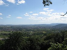
The Mont Saint-Michel seen from Saint-Jean-Saverne |
||
| height | 437 m | |
| location | Alsace , France | |
| Mountains | Vosges | |
| Coordinates | 48 ° 46 '28 " N , 7 ° 20' 51" E | |
|
|
||
The Mont Saint-Michel , German: Michaelsberg , in the Vosges is a 437 m high mountain in Alsace above the city and abbey of Saint-Jean-Saverne ( German St. Johann bei Zabern ). It houses a Michaels sanctuary like its more famous namesake in Normandy , but has no historical connection with it.
history
The mountain, called Hertenstein in older medieval sources (first mentioned in 1126) or later Bruderberg or Bruderstein (after a hermit who lived here), was already settled in Celtic and Roman times. From a Celtic town from the La Tène period - nowadays called Heidenstatt in the popular parlance of tourists - two 400 m long parallel ramparts, which run through the forest at a distance of 700 m in a west-east direction, are clearly visible. The system had a pincer gate on both sides .
Witnesses of the Roman settlement are a boundary stone with a rudimentary inscription (PV), which is interpreted in such a way that here public area ( publicus ) met private, as well as a 64 m long paved path with car ruts, which has a gradient of 30 % led up the mountain.
The history of the mountain as a St. Michael's shrine does not begin until 1593. In that year Johann Schreyer, Abbot of St. Johann bei Zabern, founded a local St. Michaels brotherhood and expanded the older Hermit Chapel into a place of pilgrimage. Only now was the mountain named after St. Michael (at the time German St. Michaelsberg ). After several devastations in the Thirty Years' War , in the French Revolution and in two world wars, which were followed by restorations in 1686, 1848 and 1952, nothing is left of the older interior fittings.
In the 1990s, the entire area around Mont Saint-Michel was documented, an archaeological hiking trail laid out and information boards provided.
geography
The mountain is mostly forested; deciduous and coniferous as well as mixed forests alternate. These are broken through again and again by spectacular red sandstone rock formations.
From the plateau on the ridge on which the sanctuary is located, one has a view of Saint-Jean-Saverne with its abbey and the neighboring town of Eckartswiller , of Ernolsheim in the north and to the east into the wide plain of the Hanauer Land towards the Rhine, in clear weather up to the Black Forest heights .
The Mont Saint-Michel forms a common ridge with the Frohnberg , a medieval quarry, the Daubenschlagfelsen with the ruins of the Warthenberg Castle above Ernolsheim in the north and with the Viergemeindenwald and the Frauenwald in the west; this also includes the Ertmura , the highest point of this complex with a height of 437 m. In addition to interesting rock formations such as Rocher des Dames and Rocher des Plates in the south, geological attractions include the pound holes in the northwest of the Frauenwald; There are more than 30 holes that are believed to have been driven into a large rock platform by farmers in wartime when they had to leave their villages in the Middle Ages in order to pound their grain. Most of the holes are filled with water. According to a local tradition, the very similar holes on Frohnberg are much older and were already used as sacrificial sites by the Celts from Heidenstatt .
Due to its remote location, the ridge was shaped by myths and legends in the Middle Ages. A natural monument is the Grotte aux fées , the cave under an overhanging sandstone rock in which the hermit is said to have lived. Previously, it is said to have been the home of witches. In a mysterious recess in the stone floor, called Hexenloch , Itha, the wife of Peter von der Lützelburg, is said to have been buried alive by her husband, who feared her because of her magical cults, in the 12th century. Presumably the depression was already a Merovingian burial place. The Michelsberger Hexentanzplatz , a stone round and presumably already a Druidic cult rock in Celtic times, lies above this grotto .
Archaeological hiking trail
The archaeological hiking trail starts at the “Croix de Langenthal” hiking car park (401 m). Here a stone cross reminds (1888 an older shrine replacing) with an inscription to a Swedish officer named Aelrichsen, who was killed at this point in the Thirty Years' War. He belonged to the pillaging army of General Ernst von Mansfeld , which wintered with his troops in Alsace in 1621/22. The date "1611" is a mystery; it is possibly a reading error in the transfer of the inscription from the destroyed wayside shrine.
The 8.5 km long main hiking trail, which can be varied and expanded through a network of combinable side paths, touches all prehistoric, Roman and medieval sites of the ridge to which Mont Saint-Michel belongs and is part of the Palatinate Forest-Vosges biosphere reserve you north .
Web link
literature
Jean-Joseph Ring: Promenades historiques et archéologiques near Saverne . Saverne 2000, ISSN 1159-4705 ( French )


