Lembach (Bas-Rhin)
| Lembach | ||
|---|---|---|

|
|
|
| region | Grand Est | |
| Department | Bas-Rhin | |
| Arrondissement | Haguenau-Wissembourg | |
| Canton | Reichshoffen | |
| Community association | Sauer-Pechelbronn | |
| Coordinates | 49 ° 0 ′ N , 7 ° 47 ′ E | |
| height | 177-551 m | |
| surface | 48.89 km 2 | |
| Residents | 1,540 (January 1, 2017) | |
| Population density | 31 inhabitants / km 2 | |
| Post Code | 67510 | |
| INSEE code | 67263 | |
| Website | www.ot-lembach.com | |
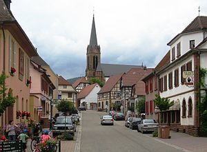
 The main street of Lembach (Route de Bitche) |
||
Lembach is a French commune with 1540 inhabitants (as of January 1, 2017) in the Bas-Rhin department in the Grand Est region (until 2015 Alsace ). It is part of the Northern Vosges Nature Park .
geography
Lembach is located in the Sauer Valley , surrounded by the forests and sandstone cliffs of the Northern Vosges on Route départementale 3. Lembach includes the districts Mattstall , Pfaffenbronn , Disteldorf, Eichholz, Les Châtaigniers, Ziegelhutte, Steinacker and Gimbelhof .
history
A section of the Maginot Line ran near Lembach in the interwar period , the traces of which are still clearly visible today. Heavy fighting raged west of the city on June 19, 1940 during World War II . By the evening of that day the German 215th Infantry Division had broken the Maginot Line in this area.
| year | 1962 | 1968 | 1975 | 1982 | 1990 | 1999 | 2007 | 2017 |
| Residents | 1742 | 1799 | 1782 | 1681 | 1710 | 1,689 | 1728 | 1540 |
Thistle village
Disteldorf is the smallest district of Lembach. The hamlet consists of 3 buildings and has 17 inhabitants (2013). It can only be reached via a forest path. Disteldorf was founded as a Köhlerdorf in the 17th century, there were 5 glass factories in the vicinity. In the 19th century more than 100 residents lived in 12 houses and there was a one-class school and a chapel. After Alsace-Lorraine was annexed to the German Empire (1871), the demand for charcoal fell and the men went to the Palatinate and Rheinhessen as forest workers. They only returned to their families once or twice a year. Disteldorf was completely destroyed in the Second World War by shelling from the Maginot fortress " Four à Chaux " (lime kiln) near Lembach, see above. The inhabitants, like most of the inhabitants of northern Alsace, were evacuated to the Haut-Vienne department. After the war, only one family returned and rebuilt their homes.
Culture and sights
Lembach is surrounded by many castles carved into the sandstone. The most important of these is the Fleckenstein from the 12th century , but the Hohenburg and the Löwenstein are also worth seeing and have an important past as Hohenstaufen fortresses. In the center are the two important churches of the place: the Protestant church from 1750 with a medieval tower and the neo-Gothic Catholic church from the 19th century. The old Lutheran church of St-Paul on the southern outskirts is also a listed building.
Leisure and Tourism
Lembach is known far beyond the country's borders, especially for its haute cuisine restaurant, as a pilgrimage destination for gourmets. The Vosges Club has marked many hiking trails in the area, which also lead to all the castle ruins and picturesque rocks.
Personalities
- Paul Bertololy (1892–1972), doctor, writer, honorary citizen of Lembach
literature
- Le Patrimoine des Communes du Bas-Rhin. Flohic Editions, Volume 2, Charenton-le-Pont 1999, ISBN 2-84234-055-8 , pp. 1580-1583.
