
Wind stone
| Wind stone | ||
|---|---|---|
.svg)
|
|
|
| region | Grand Est | |
| Department | Bas-Rhin | |
| Arrondissement | Haguenau-Wissembourg | |
| Canton | Reichshoffen | |
| Community association | Pays de Niederbronn-les-Bains | |
| Coordinates | 49 ° 0 ′ N , 7 ° 41 ′ E | |
| height | 195-517 m | |
| surface | 11.97 km 2 | |
| Residents | 164 (January 1, 2017) | |
| Population density | 14 inhabitants / km 2 | |
| Post Code | 67110 | |
| INSEE code | 67536 | |

Windstein is a French commune with 164 inhabitants (as of January 1, 2017) in the Arrondissement of Haguenau-Wissembourg , in the Bas-Rhin department and in the Grand Est region (until 2015 Alsace ). The municipality belongs to the Pays de Niederbronn-les-Bains municipal association .
geography
Windstein is located in a heavily forested area between the Forêt de Katzenthal and the Forêt de Niederbronn on the former Maginot Line . Jaegerthal belongs to the community .
Population development
| year | 1962 | 1968 | 1975 | 1982 | 1990 | 1999 | 2006 | 2016 |
| Residents | 216 | 191 | 201 | 185 | 166 | 174 | 164 | 164 |
| Sources: Cassini and INSEE | ||||||||
Attractions

Mittelkopf (515 m) on the left and Steinkopf (515 m) in the north of Windstein

Altwindstein Castle
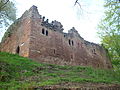
Neuwindstein Castle

Remains of the old forge in Jaegerthal


literature
- Le Patrimoine des Communes du Bas-Rhin. Flohic Editions, Volume 2, Charenton-le-Pont 1999, ISBN 2-84234-055-8 , pp. 901-902.
Web links
Commons : Windstein - collection of images, videos and audio files
Wikisource: Winstein in the Topographia Alsatiae (Matthäus Merian) - sources and full texts