
Kaltenhouse
| Kaltenhouse | ||
|---|---|---|

|
|
|
| region | Grand Est | |
| Department | Bas-Rhin | |
| Arrondissement | Haguenau-Wissembourg | |
| Canton | Bischwiller | |
| Community association | Haguenau | |
| Coordinates | 48 ° 47 ' N , 7 ° 50' E | |
| height | 127-150 m | |
| surface | 3.72 km 2 | |
| Residents | 2,333 (January 1, 2017) | |
| Population density | 627 inhabitants / km 2 | |
| Post Code | 67240 | |
| INSEE code | 67230 | |
 Mairie Kaltenhouse |
||

Kaltenhouse (Alsatian: Kàltehüse , German: Kaltenhausen ) is a French commune with 2,333 inhabitants (as of January 1, 2017) in the Bas-Rhin department in the Grand Est region (until 2015 Alsace ). It belongs to the Arrondissement of Haguenau-Wissembourg and the Canton of Bischwiller .
geography
The municipality of Kaltenhouse is located on the Moder , about seven kilometers southeast of Haguenau . The landscape in the modern lowlands is flat, sandy and characterized by gravel pits. The now disused Steinbourg – Rastatt railway runs through the community . Neighboring communities of Kaltenhouse are Haguenau in the southwest, west and north and Oberhoffen-sur-Moder in the east and southeast.
history
The municipality was separated from the canton of Haguenau and incorporated into the canton of Bischwiller on January 1, 2015 .
Population development
| 1962 | 1968 | 1975 | 1982 | 1990 | 1999 | 2008 | 2013 |
|---|---|---|---|---|---|---|---|
| 1,396 | 1,567 | 1,608 | 1,640 | 1,695 | 1,897 | 2,179 | 2,220 |
Attractions
- St. Wendelin Church, built in 1872 instead of a St. Wendelin chapel built in 1443; the organ comes from the Stiehr house
- St. Wendelin Church
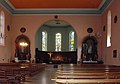
altar
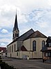
West side

organ


literature
- Le Patrimoine des Communes du Bas-Rhin . Flohic Editions, Volume 1, Charenton-le-Pont 1999, ISBN 2-84234-055-8 , pp. 468-469.
Web links
- Kaltenhouse on cc-bischwiller.fr (French)