
Gundershoffen
| Gundershoffen | ||
|---|---|---|
.svg)
|
|
|
| region | Grand Est | |
| Department | Bas-Rhin | |
| Arrondissement | Haguenau-Wissembourg | |
| Canton | Reichshoffen | |
| Community association | Pays de Niederbronn-les-Bains | |
| Coordinates | 48 ° 54 ' N , 7 ° 40' E | |
| height | 163-261 m | |
| surface | 17.55 km 2 | |
| Residents | 3,679 (January 1, 2017) | |
| Population density | 210 inhabitants / km 2 | |
| Post Code | 67110 | |
| INSEE code | 67176 | |
| Website | www.gundershoffen.fr | |
.JPG) Mairie Gundershoffen |
||

Gundershoffen ( German : Gundershofen ) is a French commune with 3,679 inhabitants (as of January 1, 2017) in the Bas-Rhin department in the Grand Est region (until 2015 Alsace ).
history
Gallo-Roman evidence shows a settlement in the first to third centuries AD. In the oldest written testimony about the place from 1232, the name Guntershoven is written. This spelling or Guntershofen lasted well beyond the 17th century.
The place belonged to the Duchy of Lorraine . Depopulated in the Thirty Years War , it was later repopulated by Swiss families. In the 18th century, the place formed a condominium between the County of Leiningen and the Landgraviate of Hessen-Darmstadt . With the upheaval started by the French Revolution , the village became French.
During the Second World War, the place suffered badly from the fighting. On December 3, 1944, it was liberated by US soldiers, but German troops captured it again. It was not until March 1945 that the German soldiers were finally expelled.
From the previously independent communities Eberbach-Wœrth , Griesbach and Gundershoffen, the new community Gundershoffen was formed on September 1, 1973, which also includes the residential areas Ingelshof (also known as Hoellenhof), Lauterbacherhof and Schirlenhof.
| year | 1962 | 1968 | 1975 | 1982 | 1990 | 1999 | 2008 | 2017 |
|---|---|---|---|---|---|---|---|---|
| Residents | 2,253 | 2,502 | 2,738 | 3,261 | 3,377 | 3,490 | 3,454 | 3,679 |
Attractions
- The Jewish cemetery, which was laid out at the end of the 18th or beginning of the 19th century, is still used today by Gundershoffen and the neighboring community of Reichshoffen .
- A mill
- Memorial in honor of the German lieutenant van Winsloë, who was killed in Gundershoffen in the Franco-Prussian War in 1870 .
Churches
- Lutheran church from the 18th century
- Saint-Jacques-le-Majeur Catholic Church
- Catholic church Saint-Vit in the district of Griesbach
- Catholic church Saint-Wendelin in the district of Eberbach

synagogue
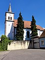
Lutheran Church
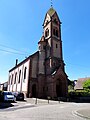
Saint-Jacques-le-Majeur church


traffic
Gundershoffen has a stop on the Haguenau – Falck-Hargarten railway line , although the TER Alsace trains only run to Niederbronn-les-Bains today .
literature
- Le Patrimoine des Communes du Bas-Rhin . Flohic Editions, Volume 2, Charenton-le-Pont 1999, ISBN 2-84234-055-8 , pp. 872-874.
Web links
- Local history Gundershoffen (French)
Individual evidence
- ^ Friedrich Knöpp: Territorial inventory of the County of Hanau-Lichtenberg Hesse-Darmstadt part . [typewritten] Darmstadt 1962. [Available in the Hessisches Staatsarchiv Darmstadt , signature: N 282/6], pp. 14, 16.
- ↑ alemannia-judaica.de
- ↑ Route table 5 TER Alsace (PDF; 109 kB)