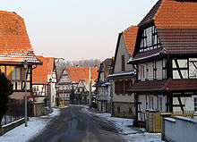
Ingolsheim
| Ingolsheim | ||
|---|---|---|

|
|
|
| region | Grand Est | |
| Department | Bas-Rhin | |
| Arrondissement | Haguenau-Wissembourg | |
| Canton | Wissembourg | |
| Community association | Pays de Wissembourg | |
| Coordinates | 48 ° 58 ' N , 7 ° 56' E | |
| height | 146-205 m | |
| surface | 4.46 km 2 | |
| Residents | 319 (January 1, 2017) | |
| Population density | 72 inhabitants / km 2 | |
| Post Code | 67250 | |
| INSEE code | 67221 | |
 Mayor and school building |
||
Ingolsheim is a French commune with 319 inhabitants (as of January 1, 2017) in the Bas-Rhin department in the Grand Est region (until 2015 Alsace ). The villagers call themselves Ingolsheimois or Ingelser . Ingolsheim is a member of the Communauté de communes du Pays de Wissembourg .
history
In a document of King Otto II from the year 967, the Bach “Ingoldeshaha” is called when describing the Weißenburger Mundat .
From 1871 until the end of the First World War , Ingolsheim belonged to the German Empire as part of the realm of Alsace-Lorraine and was assigned to the Weißenburg district in the Lower Alsace district .
At the beginning of the Second World War , the villagers were evacuated to Bessines-sur-Gartempe because of Ingolsheim's proximity to the Maginot Line and the Schoenenbourg artillery plant .
Population development
| year | 1962 | 1968 | 1975 | 1982 | 1990 | 1999 | 2008 | 2016 | |
| Residents | 204 | 204 | 198 | 199 | 250 | 269 | 288 | 319 | |
| Sources: Cassini and INSEE | |||||||||
See also
literature
- Le Patrimoine des Communes du Bas-Rhin. Flohic Editions, Volume 2, Charenton-le-Pont 1999, ISBN 2-84234-055-8 , p. 1271.
Web links
Individual evidence
- ↑ Theodor Sickel (Ed.): Diplomata 13: The documents Otto II and Otto III. (Ottonis II. Et Ottonis III. Diplomata). Hannover 1893, pp. 22–23 ( Monumenta Germaniae Historica , digitized version ), Certificate No. 15.
- ↑ Ingolsheim on cassini.ehess.fr
- ↑ Ingolsheim on insee.fr

