
Rott (Bas-Rhin)
| Red | ||
|---|---|---|
.svg)
|
|
|
| region | Grand Est | |
| Department | Bas-Rhin | |
| Arrondissement | Haguenau-Wissembourg | |
| Canton | Wissembourg | |
| Community association | Pays de Wissembourg | |
| Coordinates | 49 ° 1 ' N , 7 ° 54' E | |
| height | 197-400 m | |
| surface | 3.24 km 2 | |
| Residents | 472 (January 1, 2017) | |
| Population density | 146 inhabitants / km 2 | |
| Post Code | 67160 | |
| INSEE code | 67416 | |
 Mairie Rott |
||

Rott is a French commune with 472 inhabitants (as of January 1, 2017) in the Bas-Rhin department in the Grand Est region ( Alsace until 2015 ).
location
Rott is located in the Palatinate Forest-Vosges du Nord biosphere reserve , three kilometers southwest of Wissembourg .
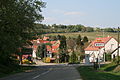
Place view

Catholic, Lutheran and Reformed Simultaneous Church of St. George


history
Between 1871 and the end of the First World War , Rott belonged to the German Empire as part of the realm of Alsace-Lorraine and was assigned to the Weißenburg district in the Lower Alsace district .
Population development
| 1910 | 1962 | 1968 | 1975 | 1982 | 1990 | 1999 | 2006 | 2017 |
|---|---|---|---|---|---|---|---|---|
| 407 | 338 | 384 | 371 | 415 | 433 | 414 | 484 | 472 |
coat of arms
Description of coat of arms : Divided into red and silver. At the top half a silver water wheel on the division.
literature
- Le Patrimoine des Communes du Bas-Rhin. Flohic Editions, Volume 2, Charenton-le-Pont 1999, ISBN 2-84234-055-8 , pp. 1588-1589.
Web links
Commons : Rott - collection of images, videos and audio files