Four à Chaux

|
||
|---|---|---|
| Four à Chaux | ||
| Type: | Artillery plant | |
| Fortress section : | Vosges | |
| Crew: | 580 men of the 165th RIF a . 168th RAP including 24 officers | |
| Commander: | Major Exbrayat | |
| construction | ||
| Inputs: | 1 × for teams (at ground level) 1 × for ammunition (sloping tunnel, upwards) |
|
| Combat blocks: | 3 × artillery bunkers , 2 × infantry bunkers , 1 × infantry casemate | |
| Power supply: | 4 × Sulzer units with 160 HP each | |
| Ammunition and armament | ||
| The ammunition was delivered by light rail or truck. Inside, the carts were pushed by hand. The system was designed for an ammunition consumption of approx. 40 t per day of major combat . | ||
| Ammunition storage: | Just a secondary ammunition store near the combat blocks. | |
| Block 1: | 1 × 13.5 cm tower, 2 × GFM bells |
|
| Block 2: | 1 × 7.5 cm tower (Mod. 32) 1 × GFM bell 1 × JM bells |
|
| Block 3: | 1 × 8.1 cm tower 1 × GFM bell 1 × LG bell |
|
| Block 4: | 1 × GFM bell 1 × VDP bell 2 × JM bells |
|
| Block 5: | 1 × machine gun turret 1 × GFM bell |
|
| Block 6: | 1 × 4.7 cm PAK / JM 1 × JM, 1 × GFM bell 1 × JM bell, 1 × VDP bell |
|
| Ammunition input: | 1 x 4.7 cm PAK / JM 1 x GFM bell |
|
| Team entrance: | 1 × 4.7 cm PAK / JM 2 × GFM bells |
|
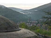
Four à Chaux (abbreviated: FAC) was an artillery plant of the French Maginot Line (the German name was Kalkofen or Panzerwerk 615) near Lembach in Alsace. The plant in the fortress section of Vosges got its name from a nearby lime kiln and, together with the Lembach infantry plant, which is only 1.5 km away, had the task of blocking the Sauer valley .
construction
The entire fortress was built into a 270 m high mountain between the Sauer and the Schmelzbach. Because of the very narrow ridge, a very compact artillery plant was created with a small extension of only about 650 m for the Maginot Line. A total of eight blocks were built between 1930 and 1935, some of which were built with 800 workers per shift working around the clock. The team entrance leads into the plant at ground level. An inclined electric elevator is installed in the ammunition entrance, which transports ammunition and other supplies to the top. This is unique for the plants in the northeast. The delivery was made by truck or the 60 cm field railway, which was only completed in May 1940. Due to the special structural conditions, the underground corridor system was only about 1.6 km long, which is why the electrification of the works railway was refrained from - the lorries with, for example, ammunition were pushed by soldiers to the bottom of the combat blocks and from there by elevator to the top transported.
The underground barracks consisted of a medical department with an operating room, a supply department for stocking food and a large kitchen with separate preparation of meals for men and officers, rest and standby rooms with showers and toilets, and a technical department with power station, as is usual for such a plant. and heating systems and related workshops. The fresh water was obtained from an underground spring.
The six combat blocks are three artillery bunkers (Blocks 1, 2 and 3), two infantry bunkers (Blocks 4 and 5) and an infantry casemate (Block 6).
Fighting
In 1938 the artillery plant was occupied with troops from the "165 e régiment d'infanterie de forteresse" (165th fortress infantry regiment) and the "168 e régiment d'artillerie à pied" (168th foot artillery regiment). On May 20, 1940, fire on German patrols was opened from here for the first time. The German 215th Infantry Division received the order on June 16 to attack the line between Windstein and Lembach, which was only fortified with log houses. The weak fortifications could only be protected by the FAC's artillery weapons when the telephone connection was working. After a few brief firefights in the days that followed, the actual attack began on June 19th. A total of 27 Stukas bombed the FAC's combat blocks from 9:00 a.m., and later also the Lembach infantry plant. More air strikes followed in the afternoon. Blasted concrete parts covered the armored turret of Block 2 so that it had to be cleared by two soldiers. The telephone line to the log cabins had also been interrupted by a chance hit. Corresponding target information could no longer be passed on. The German troops achieved the breakthrough and they were already in Haguenau that evening. The Four à Chaux artillery plant last fired a few volleys on June 24, 1940 at around 5:00 p.m. It was not until July 1, six days after the armistice, that the crew of the Four à Chaux surrendered to the written instructions of the French army command with all warlike honors. The next day the teams were disarmed. Between 1940 and 1944 the German Wehrmacht carried out several attempts at explosions with the Taifun pioneer weapon , which destroyed practically all of the armored turrets. The diesel units were also dismantled.
The fortress today
Between 1951 and 1953 the French army had the plant repaired except for Block 1. It still belongs to the Air Force today. However, the Lembach & Surroundings tourist association has been able to open the artillery to the public since 1983. In addition to the facility itself (team entrance, barracks, Block 2, etc.), a museum with a memorial for the French and German fallen soldiers can be visited. Individual tours are not carried out.
The factory surface is military area and may not be entered. An inspection is life-threatening because of the infantry obstacles that still exist there (including sunk steel spikes).
literature
- Jean Paul Pallud: Blitzkrieg in the West . London 1991, ISBN 0-900913-68-1 , pp. 555-558 .
- Jean Bernard Wahl: Then and Now. The Maginot Line . Hamburg 2000, ISBN 3-8132-0685-8 , pp. 345-349 .
- Jean Bernard Wahl: The Maginot Line in Alsace . Steinbrunn-le-haut 1989, ISBN 2-86339-034-1 , p. 82-98 .
Web links
- Fortress website
- Origin, fighting and other information
- Artillery works Four à Chaux: details, photos and directions
Coordinates: 48 ° 59 ′ 48.4 " N , 7 ° 47 ′ 51.8" E


