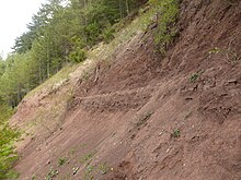
Red formation

The Röt Formation is the only formation of the Upper Buntsandstein , a lithostratigraphic subgroup of the Buntsandstein group of the Germanic Triassic . The rock unit of the Röt Formation is underlain by the Solling Formation of the Middle Buntsandstein and overlaid by the subgroup of the Lower Muschelkalk .
definition
The base of the Röt salinar is defined as the lower limit of the Upper Buntsandstein . In the edge areas where there are no evaporites , the border is placed at the base of the Chirotherien slate or at the base of the slab sandstone . The upper limit is also the limit to the shell limestone. The Buntsandstein / Muschelkalk boundary is by definition placed at the base of the boundary yellow limestone. The Upper Buntsandstein mainly consists of clayey and silty sediments in which evaporites ( gypsum , anhydrite and rock salt ) can be stored. In the edge areas there are also sandy layers (e.g. the "red quartzite"). In other areas, calcareous and dolomitic layers ("myophoric dolomites ") intervene. The Upper Buntsandstein can reach a thickness of up to 350 m in the center of the basin with embedded evaporites, and up to 240 m without salt. The lower limit of the lithostratigraphic subgroup of the Upper Buntsandstein or the Röt Formation is biostratigraphically dated to the late Olenekian , the upper limit (and thus the lower limit of the shell limestone) to the early Anisian . Geochronologically, this corresponds roughly to the period from 243 to 244.5 million years.
Storage room
At the beginning of the period of deposition of the Upper Buntsandstein, the sedimentation conditions in the Germanic Basin changed . The sea penetrated from the east through the Eastern Carpathian Gate into the basin. In the central part of the basin in northern Germany, two salt deposits were deposited, which together can be over 100 m thick. In contrast, marine carbonates have already been deposited in the area of the Eastern Carpathian Gate.
Individual evidence
- ↑ According to Menning et al. (2005), however, these values must be corrected to between 246.6 and 247.4 million years. However, the authors recommend using the numbers in the Stratigraphic Table of Germany until the new dates can be further confirmed.
literature
- Manfred Menning, Reinhard Gast, Hans Hagdorn, Karl-Christian Käding, Theo Simon, Michael Szurlies and Edgar Nitsch: time scale for Permian and Triassic in the Stratigraphic Table of Germany 2002, cyclostratigraphic calibration of the higher Dyas and Germanic Triassic and the age of the Roadium levels to Rhaetium 2005. Newsletters on Stratigraphy, 41 (1-3): 173-210, Stuttgart 2005, ISSN 0078-0421
- Jochen Lepper, Dietrich Rambow and Heinz-Gerd Röhling: The red sandstone in the Stratigraphic Table of Germany 2002. Newsletters on Stratigraphy, 41 (1-3): 129-142, Stuttgart 2005, ISSN 0078-0421
Web links
- German Stratigraphic Commission (Ed.): Stratigraphische Tisch von Deutschland 2002 . Potsdam 2002, ISBN 3-00-010197-7 - PDF; 6.57 MB (large)