Verbandsgemeinde Otterbach
| coat of arms | Germany map | |
|---|---|---|

|
Coordinates: 49 ° 29 ' N , 7 ° 44' E |
|
| Basic data (as of 2014) | ||
| Existing period: | 1971-2014 | |
| State : | Rhineland-Palatinate | |
| County : | Kaiserslautern | |
| Area : | 47.17 km 2 | |
| Residents: | 9304 (Dec. 31, 2012) | |
| Population density : | 197 inhabitants per km 2 | |
| License plate : | KL | |
| Association key : | 07 3 35 5006 | |
| Association structure: | 7 municipalities | |
| Association administration address : |
Konrad-Adenauer-Strasse 19 67731 Otterbach |
|
| Mayor : | Heinz Christmann (–2010), Harald Westrich (2010–2014) | |
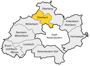
| Location of the Verbandsgemeinde Otterbach in the Kaiserslautern district | ||
The Verbandsgemeinde Otterbach was an administrative unit in the legal form of a regional authority in the district of Kaiserslautern in Rhineland-Palatinate . The Verbandsgemeinde belonged to seven independent local communities , the administrative seat was in the eponymous community Otterbach . On 1 July 2014, the municipality Otterbach with was Verbandsgemeinde Otterberg to otterbach-otterberg merged.
The association was located in the upper Lautertal , directly in front of the university town of Kaiserslautern and was traversed by the B 270 along its entire length, the Kaiserslautern- Lauterecken / Grumbach railway ran parallel .
Association members communities
| Local parish | Area (km²) | Residents |
|---|---|---|
| Frankelbach | 5.29 | 318 |
| Hirschhorn / Palatinate | 3.32 | 752 |
| Katzweiler | 9.42 | 1,693 |
| Mehlbach | 9.02 | 1,117 |
| Olsbrücken | 7.22 | 1,065 |
| Otterbach | 6.20 | 3,917 |
| Sulzbachtal | 6.71 | 442 |
| Verbandsgemeinde Otterbach | 47.17 | 9,304 |
(Resident on December 31, 2012)
history
The Verbandsgemeinde Otterbach was created in 1971 as part of a functional and territorial reform in the state of Rhineland-Palatinate .
In the course of the second Rhineland-Palatinate municipal and administrative reform , which began in 2010 , the municipalities of Otterbach and Otterberg were to be merged on the basis of the so-called "voluntary phase" that ran until June 30, 2012.
On December 14, 2010, the municipal councils of the two municipalities decided in separate but simultaneous meetings to merge the neighboring municipalities in 2014. The merger agreement was signed by the two mayors, Harald Westrich (Verbandsgemeinde Otterbach) and Martin Müller (Verbandsgemeinde Otterberg) on signed the same day.
According to the "State Law on the Voluntary Formation of the New Association of Otterbach-Otterberg" enacted on December 20, 2011, a new community with the name of " Otterbach-Otterberg " was formed on July 1, 2014 . The administrative seat is the city of Otterberg , a second administrative office is to remain in Otterbach. The election to the municipal council and the mayor of the new municipality took place on the day of the general municipal elections in 2014.
Population development
The development of the population of the Verbandsgemeinde Otterbach in relation to the administrative area at the time of dissolution; the values from 1871 to 1987 are based on censuses:
|
|
politics
Association municipal council
The Verbandsgemeinderat Otterbach consisted of 24 honorary council members and the full-time mayor as chairman.
The distribution of seats in the municipal council:
| choice | SPD | CDU | FDP | LEFT | FWG | total |
|---|---|---|---|---|---|---|
| 2009 | 10 | 7th | 1 | 1 | 5 | 24 seats |
| 2004 | 9 | 8th | 1 | - | 6th | 24 seats |
coat of arms
The blazon of the coat of arms reads: "In a blue shield border in silver, divided by a blue wavy bar, above a blue otter with a black fish in its mouth, below a green oak branch with two green leaves and two golden acorns, each with a black salt crystal" .
It was approved by the Neustadt district government in 1976 .
traffic
The Lautertalbahn runs through the area of the former municipality in a south-north direction, with a total of five stops there: Lampertsmühle-Otterbach , Katzweiler, Hirschhorn / Pfalz, Untersulzbach and Olsbrücken.
Web links
Individual evidence
- ↑ State law of December 20, 2011 (PDF; 3.6 MB)
- ↑ State Statistical Office Rhineland-Palatinate - regional data
- ^ The Regional Returning Officer Rhineland-Palatinate: Local elections 2009, Verbandsgemeinderatswahlen
- ^ Karl Heinz Debus: The great book of arms of the Palatinate . Neustadt an der Weinstrasse 1988, ISBN 3-9801574-2-3

