
Mollenkopf (Palatinate Forest)
| Mollenkopf | ||
|---|---|---|
 Summit area of the Mollenkopf |
||
| height | 506 m above sea level NN | |
| location | Bad Dürkheim district , Rhineland-Palatinate , Germany | |
| Mountains | Palatinate Forest | |
| Coordinates | 49 ° 23 '38 " N , 7 ° 59' 2" E | |
|
||
| rock | Lower red sandstone of the Palatinate (Rehberg and Schlossberg layers) | |

The Mollenkopf is a 506 meter high mountain in the Palatinate Forest 2 km northeast of Esthal and about 1.5 km east of the Morschbacherhof . Its summit is in the district of Weidenthal and is in the Bad Dürkheim district in Rhineland-Palatinate . Sandstone rocks of the Mollenkopffel can be found in the summit area.
Geographical location
The Mollenkopf is the highest point in the community of Weidenthal and is located in the Palatinate Forest Nature Park. The southern flank extends into the Esthal and Frankeneck districts. The neighboring elevations are in the northwest of the Heidenkopf (477 m above sea level) and in the south of the Michaelsberg (490.9 m above sea level).
tourism
The summit area is crossed by two hiking trails; the connecting path "Weißer Punkt", which connects the main hiking trails "Weiß-Roter Balken" and "Gelb-Roter Balken" of the Palatinate Forest Association, as well as the "Pfalzgrafen Wanderweg", which is part of the former West Palatinate hiking trail . This path is marked with a yellow W. A small rest area was created.
As part of the stone setting project, two monuments were erected in 2004. One is a dolmen .
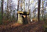
Dolmen on the Mollenkopf

Rest area and the stone of encounter


literature
- Michael Geiger et al. (Hrsg.): The Palatinate Forest, portrait of a landscape . Publishing house Palatinate cultural studies, Landau / Pf. 1987, ISBN 3-9801147-1-6
Individual evidence
- ^ State Office for Geology and Mining Rhineland-Palatinate: Geological overview map of Rhineland-Palatinate . Retrieved January 4, 2015
- ↑ Landscape information system of the nature conservation administration: map service . Accessed December 31, 2015
- ↑ Stone-setting project of the schools of the Lambrecht community. A stone setting project - design in nature . Retrieved January 4, 2015