
Le Thuit-Signol
| Le Thuit-Signol | ||
|---|---|---|
.svg)
|
|
|
| local community | Le Thuit de l'Oison | |
| region | Normandy | |
| Department | Your | |
| Arrondissement | Bernay | |
| Coordinates | 49 ° 16 ' N , 0 ° 56' E | |
| Post Code | 27370 | |
| Former INSEE code | 27638 | |
| Incorporation | January 1, 2016 | |
| status | Commune déléguée | |
 Former town hall of Le Thuit-Signol |
||

Le Thuit-Signol is a village and a former French commune with 2,429 inhabitants (as of January 1 2017) in the department of Eure in the region of Normandy . It belonged to the Bernay arrondissement and the Bourgtheroulde-Infreville canton (until 2015: Amfreville-la-Campagne canton ). The inhabitants are called Thuit-Signolais .
With effect from January 1, 2016, the former municipalities of Le Thuit-Anger , Le Thuit-Signol and Le Thuit-Simer were merged to form a commune nouvelle called Le Thuit de l'Oison and have since had the status of a commune in the new municipality déléguée . The administrative headquarters are in Le Thuit-Signol.
location
Le Thuit-Signol is located in northern France about 22 kilometers south-southwest of Rouen .
Population development
| year | 1793 | 1851 | 1886 | 1921 | 1962 | 1968 | 1975 | 1982 | 1990 | 1999 | 2006 | 2012 | |
| Residents | 935 | 966 | 824 | 453 | 532 | 602 | 1,175 | 1,574 | 1,649 | 1,766 | 2,046 | 2,252 | |
| Source: Cassini and INSEE | |||||||||||||
Attractions
- Saint-Ouen church
- Calvaire
- Dorival mansion

Saint-Ouen church
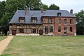
Dorival mansion
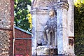
Calvaire


