
Shallows of the Rhine


Shallows of the Rhine can be found in numerous places in its course. In the course of time, the Rhine has dug a very narrow and winding river bed through the Rhenish Slate Mountains . Rocks remained above and below the surface of the water, which hindered navigation on the Rhine or endangered them when the water levels were low. Today, many of these shallows have been removed or defused by the expansion of the Rhine. The old names that were coined by boatmen and fishermen still exist. Between Sankt Goar and Oberwesel shipping is by means of light signals since 1972 aware of looks . Until 1988, the Rhine pilots were active on the route from Sankt Goar to Bingen .
The most famous shoals
| Surname | km | shore | description |
|---|---|---|---|
| millstone | 529.2 | RU | A Rhine mill used to be anchored on this rock, which lies close to the banks of the Rhine between Rüdesheim and Ehrenfels Castle . The heart of the history professor Niklas Vogt , a teacher of Prince von Metternich, lies beneath an iron cross embedded in the rock . |
| Fiddel | 529.4 | RU | Rock, on which the customs chain between the Binger mouse tower and Ehrenfels Castle was previously attached. |
| Binger hole | 530.6 | fairway | Under the government of Friedrich Wilhelm III. the fairway was extended to 30 meters. A memorial was erected there in 1832. The current width is 120 meters. |
| Perforated bricks | 530.6 | Remains of the rock barrier in Binger Loch. | |
| Long place | Denotes the end of the narrow passage at Binger Loch . | ||
| Beckersley | 532.2 | LU | Slate rock, formerly owned by the Becker family. |
| Big and small last | 532.3 | RU | Rocks running in the direction of the current, in Assmannshausen . |
| Clemensgrund | 533.7 | RU | Named after the former parish church of Sankt Clemens in Trechtingshausen . |
| Teufelskader Leyen | 534.9 | RU | Rock, from the Latin cataracta = lock, waterfall. Devil possibly personal name or reference to a disreputable place. |
| Rösselgrund | 535.5 | LU | Shallow; Rossel or Rösel denotes a scree slope from which stones roll down. |
| Heimbacher Hole | 537.0 | LU | Narrow waters. |
| Great Wacken | 537.2 | RU | Mhd. Wacke, field stone protruding from the ground. |
| Cariusley | 538.8 | RU | Rocks at Lorcher Werth. |
| Lorcher church lily | 540.1 | RU | Rock near the church of Saint Martin. |
| Cross benches | 541.3 | RU | Rock bank at the former Fürstenthal monastery. |
| Groscheley | 541.6 | RU | rock |
| Lorchhausen reason | 542.2 | LU | Shoals and Kribben near Lorchhausen . |
| Wirbelley | 542.9 | RU | Rock slope near the vortex. |
| Macaw Bacchi | 543.4 | fairway | 1850 blasted rock. Also Elterstein or Altarstein . |
| Fin ripper | 543.5 | LU | Rock that tears the rafts apart. |
| The wild danger | 544.7 | LU | Fairway between Kauber- and Bacharacher Werth , defused since 1976. |
| Weinsteinerleyen | 544 | LU | Rocks between LU and Bacharacher Werth. |
| Thieves | 544 | LU | Rocks between LU and Bacharacher Werth. |
| Rauscheley | 547.3 | RU | Rock, term for scree slopes on the Middle Rhine. |
| Gruyeregrund | 547.6 | RU | shallow |
| Wolfsnacker benches | 548.2 | RU | Rocks, perhaps named after the wolf that used to live here. |
| Rabenley | 548.8 | LU | Rocks on which ravens nest. |
| Kirchley | 549.6 | LU | Rocks at the Liebfrauenkirche. |
| Rossstein | 550.7 | RU | Rock, perhaps derived from me rosteyne - flax roast or rough, bare stone. |
| The seven virgins | 550.9 | RU | Rocks and sandbar. According to the legend, the seven rocks are seven petrified virgins from the Schönburg , who were petrified as punishment for the jokes they did with their suitors. |
| Hammer Leyen | 550.8 | LU | Rock with Hamm is the name given to the outer arch of a river bend. |
| Deaf Werth | 551.0 | LU | Island; Baptism refers to a shallow water hole, when the tide is low you can walk to the island. |
| Maarley | 551.5 | LU | rock |
| Urbach reason | 552.0 | RU | Shoal, alluvial cone of the Urbach. |
| Furtsley | 552.1 | RU | Rocks, ford, d. H. shallow spot in the water. |
| Geisenrücke and Heringsnas | 552.0-552.5 | Rocks, rock ridge running lengthways in the river, reminiscent of the back of a goat, Heringsnas is the southern tip. If the water level in Kaub is less than 1.30 m, the left bank of the Rhine is closed. | |
| Kammereck | 552.9 | LU | Rocks, too kamme - land that belongs to the manorial financial management. |
| Alkensteine | 553.1 | RU | rock |
| Sennerley | 553.2 | RU | rock |
| Corner benches | 553.4 | LU | Rock bank on the Betteck. |
| The lunge and the Schappe | 554.0 | RU | From Latin longus - long and mhd. Schopp - shed, barn , building on the bank. At 26 meters, the Loreley was the deepest point in the Rhine. |
| Betteck | 554.0 | LU | Rocks, signal point |
| Fourteen helpers | 554.0 | LU | Rock; on the embankment, just before the tunnel entrance to the Betteck tunnel, there are 14 stylized holy houses , the area from St. Goar to Oberwesel has always been feared by boatmen. |
| Lützelsteine | 554.3 | LU | Felsen, mhd. Lützel = small (cf. English little), signal point. |
| Green ground | 555.0 | RU | Shoal, see Grien - gravel, rubble. Largely eliminated in 1976. |
| The clode | At St.Goar. Clode - Narrow place, or derived from the personal name Cloth. | ||
| Bank check or bank stones | 555.4 | LU | Rock, today the location of the signal point and pilot museum. |
| Hard stones | 556.3 | RU | Rock group |
| Black ground | 556.3 | LU | Alluvial cone |
| Kettle and vortex | 555.6 | LU | rock |
| Donkey ground | 555.9 | RU | Shallows, deposits of the forest stream, a wooden frame is also referred to as donkey . |
| Hasenbachgrund | 556.7 | RU | Shallow Hasenbach estuary. |
| At the Hottentot | 559.2 | LU | Rock; The corruption of Hundort directly at the Hundhafen. In Rhenish, dog is also called a strong Christmas tree . |
| Wellmicher place | 559.7 | RU | Sandbank at the mouth of the Wellmicher Bach. |
| Gaulsgrund | 562.0 | RU | Shallow at Gaulsbach. |
| Hirzenacher Leyen | 562.8 | LU | rock |
| Kesterter reason | 563.0 | RU | Gravel ground on the sliding slope near Kestert |
| At the Nonnenstein | 563.8 | LU | Shallow, this is where pilgrims used to cross on their way to Kamp-Bornhofen . |
| Kesterter Leyen | 563.9 | RU | Outcrop |
| At the tailor | 565.2 | LU | Roadstead , Bad Salzig (family name) |
| On the stone man | 568.1 | LU | Shallows, old milestones on the bank. |
| Bornhofen reason | 567.8 | RU | Bottom, shoal |
| Martinsgrund | 569.5 | LU | Shoal, named after the St. Martin chapel mentioned in 911. |
| Bischofsgrund | 569.3 | RU | Shoal of gravel near the old castle in Kamp . |
| Filsener Leyen | 570.3 | RU | Rocks near Filsen . |
| Filsen reason | 572.5 | RU | Scree bank at Filsen. |
| Peternacher Leyen | 573.3 | LU | Shallows, slate rocks near the former Peternach settlement. |
| Easter spa sand | 573.8 | RU | Sandbank on the sliding slope near Osterspai . |
| On the Schottel | 576.5 | LU | Shallow, previously long gravel ridges; Schotter-Schottel. |
| The narrow door | 576.5 | RU | earlier fairway for ships with little draft. |
| Kippers base | 579.0 | LU | shallow |
| Niederspayer fairway | 580.0 | LU | shallow |
| Braubacher Grund | 580.0 | RU | Shallow , separates Braubacher from Nieder spayer fairway. |
| Breyer Leyen | 581.0 | LU | Rocks at Brey . |
| Schlierbachsort | 581.7 | RU | Alluvial cone mouth Schlierbach. |
| Königsstuhlgrund | 583.7 | LU | Shallow at the height of the Königsstuhl near Rhens . |
| Kapuzinergrund | 591.5 | LU | Shallow in Koblenz , on which the Romans built a bridge over the Rhine in 49 AD . |
| Unkelstein | 636.6 | LU | Basal reef across from Unkel |
| Deutz plate | 687.3 | fairway | 500 m long gravel and sand bank created by the widening of the river bed and the associated reduction in flow velocity below the port entrance. |
Common name components
- Bank - sand or gravel bank
- Corner - sharp bend in the river or ledge
- Danger - dangerous place, sometimes also vehicle
- Grien - sandy shore, from Middle High German, partly also green
- Bottom - deposits in the area of river mouths and sliding slopes
- Ledges - rock ridge in the direction of the river
- Ley - rocks, slate rocks
- Hole - cut into a rock barrier
- Back - elongated elevation
- Wacken - thick boulder
- Eddy - whirlpool
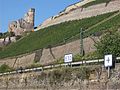
"Short kilometer" near Rüdesheim

The seven virgins
Geisenrück

Bächerley

Kammereck

Remnants of the Lützelsteine

Shallow at the bank corner, in the foreground: Schwarzgrund

Signal point at the bank corner

Rabenley at low tide 2011

Wirbeley at low water in 2011

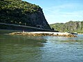
Stuck freighter on the Deutz plate


See also
literature
- Manfred Halfer: water field names in Rheinengtal . In: Hansenblatt . No. 52 , 1999.
- Paul Huebner: The Rhine . From the sources to the mouths. 1st edition. dtv , Munich 1974, ISBN 3-423-10004-4 (with 18 maps by A. Wolf and 26 illustrations).
Web links
- Rhine shipping history: Rhine expansion in the Binger Loch area
- The Rhine in detail, route description
- Aerial photos from Bingen to Sankt Goar
- Notes from the Rüdesheim city archive: floodplains and rocks in the Middle Rhine
- Picture of the 7 virgins from JF Dielmann, A. Fay, J. Becker (draftsman): FC Vogel's panorama of the Rhine, pictures of the right and left banks of the Rhine, FC Vogel lithographic institution, Frankfurt 1833