
Orsoy
|
Orsoy
City of Rheinberg
|
||
|---|---|---|
 |
||
| Height : | 22.5 (20-25) m above sea level NN | |
| Area : | 14.75 km² | |
| Residents : | 4177 (Nov 9, 2011) | |
| Population density : | 283 inhabitants / km² | |
| Incorporation : | 1st January 1975 | |
| Postal code : | 47495 | |
| Area code : | 02844 | |
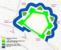
Location of Orsoy in North Rhine-Westphalia |
||


Orsoy ( IPA : [ ˈoɾsaʊ̯ ]) is a district of the North Rhine-Westphalian city of Rheinberg on the left Lower Rhine . Translated, the word Orsoy (spoken: in the dialect short and hard: Oschau ) means something like "horse meadow" (Rossaue). Because of the Rhine promenade, its fortress walls and its historic buildings, Orsoy is a popular excursion destination, from which the Orsoy – Walsum ferry can cross to the Duisburg district of Walsum on the right bank of the Rhine .
geography
Geographical location
Orsoy is on the left bank of the Rhine on the Lower Rhine . Due to strong mountain depressions , large parts of the place are below or just above the water level of the Rhine.
climate
Orsoy has a temperate climate all year round . The annual average temperature is around 11 ° C and fluctuates between 3 ° C in February and 20.1 ° C in July. The mean minimum temperature is just above the frost line. There is a risk of frost between September and April.
At the same time, the monthly maximum and minimum values are far apart. In addition to mild winters with daily highs of around 14 ° C, there are also cold winters with lows of down to −17 ° C. There are hot, dry summers as well as cool, humid summers.
The annual rainfall is around 640 mm. The wettest months are July and August. Every month, precipitation falls on 9 to 14 days. Due to the generally mild climate, snowfall is rare.
| Orsoy | ||||||||||||||||||||||||||||||||||||||||||||||||
|---|---|---|---|---|---|---|---|---|---|---|---|---|---|---|---|---|---|---|---|---|---|---|---|---|---|---|---|---|---|---|---|---|---|---|---|---|---|---|---|---|---|---|---|---|---|---|---|---|
| Climate diagram | ||||||||||||||||||||||||||||||||||||||||||||||||
| ||||||||||||||||||||||||||||||||||||||||||||||||
|
Average monthly temperatures and rainfall for Orsoy
Source: [3] Orsoyerberg private weather station, weather data from 2005,
|
||||||||||||||||||||||||||||||||||||||||||||||||||||||||||||||||||||||||||||||||||||||||||||||||||||||||||||||||||||||||
Orsoy fortress
| Period | description |
|---|---|
| 1139-1273 | Fortified city (place with rural property) |
| 1273-1438 | Fixed city (A city is so named after the wall and city gates are erected) |
| 1565-1581 | Fortress (New Italian) |
| 1632-1640 | Fortress (old Dutch) |


The place is surrounded in large parts by a medieval city wall with 4 city gates (1st ring of fortifications) . The last of the still existing historical city gates (Kuhtor) was destroyed during the war in 1945. The gates themselves were double gates with a front gate, kennel and the main gate. At the main gate (cow gate) an upstream barbican was built early on (see illustration: Orsoy fortress around 1650). The flood protection gate (water gate or Rhine gate) still in use today was only built in 1937. There were also various wall towers and 4 corner towers. The 18-meter-high powder tower (formerly the mill tower - originally the only corner tower of the city wall integrated into the wall) illustrates the dimensions of the city fortifications. Only the foundation and remains of the foundation walls of the blue tower have been preserved.
The second fortification ring - 5 bulwarks ( bastions ), main wall, main moat - is completely preserved. The five bulwarks are made of earth with a brick foundation at trench height. This masonry base of the bulwarks is covered by earth and vegetation, but this base is exposed in two places in Orsoy. The five bastions and the walk-in curtains between them are accessible via paths (as part of the Wall Promenade Ring). They still stand out clearly from the landscape and are under monument protection .
The Orsoy fortress was built after two different fortress renovations: New Italian (2nd ring) and Old Dutch (3rd ring).
The new Italian part goes to Johann d. Ä. Pasqualini (son of Alessandro Pasqualini ) back. The five bulwarks also belong to this part. The connections between the individual bulwarks ( bastions ) are called curtain walls or in German: the main wall (e.g. south wall). In front of it lies the water surface of the former main ditch. The main moat is now completely dry, except for the area in front of the Kuhpforte bastion (cow pond - see illustration: Historic fortifications: fortification ring 1 + 2).
The old Dutch part represents the 3rd ring of fortifications . The four ravelins between the bulwarks belong to this old Dutch part . The main ditch was expanded and widened to build the ravelins. The “Zollinsel” (in the Rhine) in front of the Rheintor was also “similar” to Ravelin, but is not considered the 5th Ravelin. The 1st ravelin between the fort and Henkes bulwark is hardly recognizable in the area. The 2nd ravelin is located on the hospital area, the 3rd in the vicinity of the cow pond. The 4th Ravelin (South Ravelin) in front of the former Binsheimer Tor faces exactly south and can still be seen very well in the open area. The last defensive element of the 3rd ring was the Niederwall (in front of the main ditch) with the covered path and the glacis in front of it .
The Orsoy fortress itself is known as the “Irregular Pentagonal Bastionary Fortress” according to the current fortress terminology. The term "irregular" refers to the adaptation of the fortress to the local topography, in particular to the Rhine as an irregular part of the fortress instead of the regular artificial moat.
Orsoy Fortress development stages
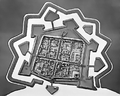
Orsoy fortress around 1650 (largest expansion stage with fastening rings 1–3)

Figure ground plan of the fortress around 1819 (after abandonment of military use)

Historical fortifications: fortification ring 1 and 2 (current situation)


history
Prehistory and the Early Middle Ages
The first traces of settlement, as for the entire Lower Rhine , point to from 750 BC. Chr. Advancing Germans out that increasingly the resident Celts displaced or are likely to have assimilated.
At the time of the Caesarian conquest of Gaul, Menapier are likely to have settled in the area of today's Orsoy. Later, Tiberius Cugerner , who had previously been to be found as Sugambrer across from Cologne , were forcibly settled between Krefeld and Kleve . In the 4th century, at the site of the later Orsoy (next to the Roman road that passes by) at least one ferry station and probably a villa rustica have been found. This homestead could also have been the nucleus of a settlement that had already begun.
With the Romans retreating in 401/402, who now defended Italy against the Visigoths , the Salian Franks increasingly came to power. (Cologne was conquered in 454). The Cugernians, who now belonged to the Franks, were joined by the Hattuarians who moved down the Rhine from the Ruhr-Lippe area and who are likely to have increasingly mixed with them.
A little outside of Orsoy in the direction of Rheinberg-Eversael, nine graves from the early Middle Ages were excavated near the Rhine in 1938 (approx. 500–630 AD). Among them are some extraordinarily rich burials (“princely graves”) from the 2nd half of the 6th century, with links to Scandinavia among the finds.
The Ruberg farm, to which the Ruberger Weg points to this day, is still in dispute as the first possible Franconian settlement. The Lower Rhine is likely to have been Christianized around 700.
High / Late Middle Ages (1139–1579)


It was not until the 12th century that Orsoy was identified and documented as a municipality or city. The earliest mention is found in a document from Hamborn Abbey , which in 1139 named its property in "Hersougen". Even here, however, a developed community seems to be assumed.
In 1225 the Kamp monastery, founded in 1123, also registered its possessions in "Orsoie". In addition, the Werden monastery and the Siegburg monastery (Benedictines), then the Bedburg monastery near Kleve and the Fürstenberg monastery near Xanten (nuns) as well as the women's monasteries Sankt Maria im Kapitol near Cologne and Gerresheim near Düsseldorf and the religious house of the Johanniter in Duisburg and those coming to Walsum possessions in and around Orsoy.
In 1233, a document from Count Dietrich IV. Von Kleve dated May 19 mentioned Orsoy as the Count's Fronhof ( curtis Orsoie ), whose income was transferred to his daughter-in-law Elisabeth, the daughter of the Duke of Brabant, for free use in the manner customary for that time . From 1238 to 1240 Orsoy was then used as a (Rhine) customs station for Kleve. However, there is no message about the beginning of this privilege. Of Dietrich V of Cleves , who ruled from 1260 to 1275, Orsoy should then have been brought to the city (see. Kastner, 42, of 1263 possible, but the earliest in 1270 likely holds) to a southern fixing against the Archbishop of Cologne, who was present in Rheinberg . Dietrich VII also founded the cities of Dinslaken , Büderich and Huissen near Arnhem .
The city of Orsoy is unlikely to have benefited sufficiently from the customs rights (if it still held them) in the 14th century, as the city was in increasing impoverishment, accelerated by a fire in 1347 and / or 1351. Nevertheless, on September 1, 1347, Emperor Ludwig IV , known as "the Bavarian", once again confirmed the designation of the city with the associated "freedoms" and the customs post for the Rhine toll.
The fact that this second city development was necessary may explain the legal uncertainty in which the city, which was by no means fully blossomed, found itself. Even after the fire in 1351, Count Johann von Kleve again privileged the city.
The fact that Orsoy never seems to have been granted market privilege may explain this cautious development of the city, although this deficiency remains a curiosity under the otherwise ample privilege for which a conclusive explanation is still lacking.
The administration of the community ( universitas ) was initially carried out by seven lay judges ( scepen , scabini ), who co-optively supplemented themselves from the nobles, and a judge ( judex ) appointed by the Clever Count. The transition to the council administration was probably completed at the end of the 13th century (Wesel 1271, Duisburg 1274), but is only documented for 1351. For the first time a bailiff is found for 1364. After the judex was increasingly limited to the jurisdiction, a mayor took over the city at the end of the 14th century . At the end of the 15th century, the transition from an oligarchy to a democracy of dignitaries took place:
The jury (common people, council friends), who were elected from four quarters into which the city had been divided for this purpose, joined the seven lay judges and the mayor . In contrast to the usual procedure in larger cities, which had three or four jury members for a quarter and ten electors per quarter from the people, only four "councilors" were elected for Orsoy.
From 1419 the Klevian Rhine toll was back in Orsoy. By 1438, Duke Adolf von Kleve had built a second castle, the so-called "great castle" in Orsoy. A teacher (schoolmaster) was first mentioned in the city in 1452. In 1461 the large Rhine dike ("Egerdeich") was completed.
Modern times (beginning around 1580)
The modern fortress Orsoy was built in the years 1565–1581. The fortress builder was the Italian Johann Pasqualini d. Ä. (responsible for building the 2nd fastening ring). The fortification was created as part of an ambitious building program by the sovereign Duke Wilhelm the Rich as the main weapon station in the Duchy of Kleve, while Düsseldorf and Jülich were similarly reinforced as the main weapon stations for the Duchies of Jülich and Berg .
In 1586 the Spaniards captured Orsoy and destroyed the city to the ground.
From 1609 - Brandenburg administration.
1632–1640 Dutch occupation. The fortress was expanded in the old Dutch style and the 3rd ring of fortifications was added.
In 1666 Orsoy came under Brandenburg administration again.
From 1672 the city of Orsoy was under French rule for a few years. When Orsoy was captured by Louis XIV, large parts of the existing fortifications were razed. The large castle with 3 towers (area 100 m × 70 m) built by the Duke of Kleve on the north wall was blown up by French troops. Only parts of the outer enclosing walls have been preserved.
In 1685 the first Rhine port was built in Orsoy.
Around 1750 the military use of the still preserved parts of the fortress ended. (cf. Klöffler 2005: Fortress Inventory)
Orsoy had an important cloth industry in the 18th century. Around 1700, the first cloth factory was founded on site, followed by others, so that in the middle of the 18th century the city assumed the leading position in the Klevian cloth industry until a large fire in 1818 destroyed almost the entire local cloth industry. Orsoy also experienced economic setbacks as a result of the Seven Years' War (1756–1763) and the relocation of the Rhine toll to Homberg in 1805.
A large part of the Orsoyer citizens lived from cigar production for almost 100 years. Tobacco products were shipped from Havana, Java or Sumatra to Holland, from there across the Rhine to Orsoy. After a large fire in 1818 initiated the decline of the flourishing cloth industry and plunged the city into great economic hardship, a period of economic boom began in 1851 with cigar production. After the Second World War , the Orsoyer tobacco industry came to an end. The reasons were a lack of stocks, production facilities and storage rooms destroyed in the war, and increasing competitive pressure from other regions. Numerous town houses still remind of the industrial heyday of the city.
In 1935/36 the harbor basin next to today's primary school was filled in as the Rhine dike was raised. From 1938 Jews from Orsoy were also expelled from their hometown and later deported. The long-established Friedemann family, who were highly respected until the Nazis came to power, were shunned and denounced by their fellow citizens, other Orsoyers, Social Democrats and Communists were beaten up in the SA -Heim on Rheinstrasse. The Jewish Friedemann family, regarded as "wealthy", was known primarily for their great social commitment in the town.

Towards the end of the Second World War, in March 1945, Orsoy was occupied by troops of the US Army. During the fighting between the Allies and the German Wehrmacht , the steeple of the Catholic Church was shelled by German troops. The bombardment came from the opposite (right) bank of the Rhine. Destroying the tower was intended to prevent possible use by enemy reconnaissance.
History after the end of the Second World War
From 1956 the rocket designer Berthold Seliger lived in Orsoy . He owned a moped workshop in Orsoy and also built the rockets here, which he launched from 1962 to 1964 in the Wadden area of Cuxhaven . From 1961 to 1972 the general a. D. and former defense policy advisor to the FDP Gerhard Graf von Schwerin had a residence in Orsoy on the Rheindamm, which he did not live in all year round.
The once flourishing tobacco processing no longer exists. A large former tobacco factory on Südwall was converted into living space in the 1990s. The most important local amenities have been preserved in Orsoy over the years. There is a primary school, two kindergartens, several doctors, an old people's and nursing home, two bakeries, a pastry shop, a savings bank and various smaller shops. The range of restaurants on offer can particularly benefit from weekend guests. A former hospital (Marienhospital with a geriatric focus) has now been closed. After the building served as a geriatric rehabilitation facility for a while, it has housed asylum accommodation since 2016. Orsoy will have more residents in the next few years through the expansion of two new residential areas.
Incorporations
On January 1, 1972, the poorly populated municipality of Orsoy-Land was incorporated into the city of Rheinberg . The city of Orsoy was added on January 1, 1975.
politics
coat of arms
Blazon : Above a crenellated silver (white) city wall with a red gate in the shield base, three silver (white) horse heads in a green shield. Meaning: This is a so-called "talking coat of arms" - the horses in the meadow = Orsoy. The city wall represents the city of Orsoy, which received city rights in the 13th century. The oldest known city seal shows the same symbols.
Buildings

Entrance portal to the Protestant church
Entrance portal Catholic Church
(former) synagogue

Powder Tower (east view)

Town hall on an emergency bill


- Powder Tower (Mühlenturm) - the 18 meter high corner tower of the old city wall, popularly known as the Pulverturm, was built around 1550 (wall thickness up to 2 meters). From the 17th century until 1865 it served as a mill tower for a windmill. Parts of the restored city wall border directly on the tower, i. H. the powder tower was the only one of the four corner towers that was integrated directly into the city wall.
- City wall - first circular wall built around 1438. Height up to 8 meters (thickness 1.25 meters), in the maximum expansion stage there were up to eleven towers and four city gates on the wall. About half of the city wall has been preserved and was restored from 1974–1976.
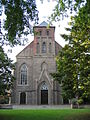
- Catholic St. Nicholas Church (three-aisled neo-Gothic hall church), built from 1843 to 1847, badly damaged in March 1945 and rebuilt without a spire in 1951. Final restoration took place from 1971 to 1974. The old Dutch high altar and four altar wings by Colijn de are important Coter , both made around 1500. At the end of the Second World War in March 1945, the tower of the church was destroyed by shelling from the other side of the Rhine. The German units of the Wehrmacht suspected that the tower was being used by advancing artillery observers and radio operators from the US Army.
- Orsoy Evangelical Church , built around 1450 as a conversion and extension of an older complex. Step hall church as a brick building in the late Gothic style. Originally consecrated to St. Nicholas, the church was assigned to the Reformed under Dutch occupation in 1632 and has been a Protestant place of worship ever since. Worth seeing: oldest Protestant pulpit on the Lower Rhine (1551). Extensive renovation measures between spring 2010 and autumn 2012. Reopening on December 16, 2012.
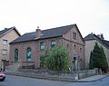
- Former synagogue - the former synagogue on the Seilerbahn has also survived the decades. In 1866 the Orsoyer Jewish community built this synagogue and school. It probably only survived the Third Reich - and with it the November pogroms - because it served as a residential building as early as 1938. The residential use still exists today.
- Former excise road customs office for the city of Orsoy on Hafendamm (near Egertor). Built at the beginning of the 18th century (around 1710). The building was restored from the ground up in 1980 (with private donations).
- Town hall, after Orsoy's complete destruction by the Spaniards in 1586, the Orsoy town hall was rebuilt around 1600. There is still an old prison cell that can be walked into the building.
- Former tobacco factory (on Südwall) - after the end of the war, it was in ruins for decades and an unofficial adventure playground. Was extensively renovated in the 1990s and converted into living space.
- Orsoy has its own jetty on the Rhine promenade. During the summer months, passenger ships (e.g. Riverlady, Rhine Queen) stop here on their way to Duisburg or in the direction of Holland.
- Flood protection gate - built in 1937 as part of the massive elevation and reinforcement of the Rhine dyke on the Lower Rhine that was carried out at that time. The gate was designed based on the historical fortress gates of the city of Orsoy and thus also gives an impression of the dimensions of a historical gate system. The facility was completely renovated at the end of the 1990s, and there are various high water level marks on the Rhine side. The Orsoy citizen rifle club has been taking care of this characteristic building on a voluntary basis for years; In the event of flooding, the gate is locked by the Orsoy volunteer fire brigade .
- In the vicinity of Orsoy, a double-circuit 380 kV line crosses the Rhine on two overhead line masts, each 105 meters high; the span between the two masts is 545 meters.
- To the north of the village is the Rhine port of Orsoy owned by NIAG .
former tobacco factory

former cath. Elementary school

Cow gate with coat of arms

Customs office at the port embankment


Flood protection
The Orsoy area is protected against Rhine floods by the highest river dikes in Europe. The Orsoy Dyke Association is responsible. The Deichgräf is the head of the dike association.
The importance of the Orsoyer Rhine arc for the animal and plant world is expressed through the almost complete protection as a landscape protection area and in particular the Rhine foreland as a nature reserve. In the cut-out areas of the foreland of the Rhine, bodies of water were created in the form of old arms of the Rhine and an alluvial forest is to emerge in this area again in the next few years.
Personalities
Honorary citizen
- Dietrich Horn (1838–1906), teacher and rector of the Evangelical Preparatory Institute; Honorary citizen on October 1, 1905
- Gerhard Bierhaus (1865–1934), tobacco manufacturer; Honorary citizen on May 5, 1925
- Iohann Landwehr (1870–1947), local politician and alderman, honorary citizen on December 19, 1930
Sons and daughters
- Johann Karl Gerhard Keller (1798–1873), Protestant pastor and Prussian member of parliament
- Friedrich Horn , called Fritz Horn, (1875–1957), German Protestant theologian
- Max Friedemann , called Mäcki (1905–1986), German-Jewish communist resistance fighter against National Socialism, interbrigadist, fighter in the Resistance, member of the German Economic Commission (DWK), operations manager of the VEB steel and rolling mills Riesa and trade council in Beijing
literature
- Heinz van de Linde: The infinitely long Egerstrasse. Memories of the Little Town of Orsoy , Books on Demand, 2005, ISBN 383343838X .
- Dieter Kastner: Rhenish City Atlas, Volume IX. No. 51. Orsoy , Habelt, R. 1989, ISBN 379271048X .
- Heinz Janssen: Orsoy in old views , publishing house European library Zaltbommel (Netherlands) 1985, ISBN 90-288-3128-2 / CIP.
- Dieter Kastner, Gerhard Köhnen: Orsoy. History of a small town , Braun, Duisburg 1981, ISBN 3-87096-160-0 .
- Otto Ottsen: Old Orsoy. Contributions to the history of the city and the office (der Drostei) Orsoy , Steiger, Moers 1980, ISBN 3-921564-16-6 (Repr. D. Aus. Orsoy 1934).
- Gerhard Köhnen: Chronicle of the Budberg community, Moers district , community administration, Budberg 1971.
- Karl Heck: History of the city and fortress Orsoy on the Lower Rhine ; Typoskr. (Rheinberg City Archives), Essen 1944.
- Gottfried B. Mertens: History of the city of Orsoy and its surroundings, together with historical documents , Wallmann, Leipzig 1921.
- Emil Stein: History of the Evangelical Reformed Congregation Orsoy , Spaarmann, Moers 1893.
- Johann H. Schürmann : Old and New from Orsoy , self-published, Orsoy 1849.
Web links
- Initiative to preserve historic buildings in Orsoy
- Information about the people, the history, associations, crafts, etc. of the Lower Rhine town of Orsoy.
- Extensive photo gallery with impressions from Orsoy.
- Orsoy image collection: http://picdeer.com/orsoy_net
Individual evidence
- ↑ Kurt Böhner, The Franconian graves of Orsoy, Mörs district. Bonner Jahrbücher 149, 1949, pp. 146–196. - Jochen Giesler: Early medieval finds from Niederkassel, Rhein-Sieg district. Bonner Jahrbücher 183, 1983, pp. 475–590, here: 513 ff. With ill. 20. - Frank Siegmund: Merovingian time on the Lower Rhine. Rheinische Ausgrabungen 34. Rheinland-Verlag 34, Cologne 1998, pp. 85 and 348–355, plates 128–137. ISBN 3-7927-1247-4
- ↑ See Kastner, 28f.
- ^ Theodor Josef Lacomblet: Document book for the history of the Lower Rhine. Düsseldorf 1840-1858, Volume I, pp. 222ff, No. 333
- ↑ Lacomblet, Theodor Joseph: Document book for the history of the Lower Rhine and the Archbishopric of Cöln, document 447. Part 3, 1853, p. [380] 360. Online edition 2009 [1]
- ^ Federal Statistical Office (ed.): Historical municipality directory for the Federal Republic of Germany. Name, border and key number changes in municipalities, counties and administrative districts from May 27, 1970 to December 31, 1982 . W. Kohlhammer, Stuttgart / Mainz 1983, ISBN 3-17-003263-1 , p. 296 .
- ↑ Description of the coat of arms on the website "Heraldry in the World"
- ↑ a b c Orsoy in old views, Volume 2 (excerpt) , accessed on February 17, 2019
