Hair
| Hair | ||
|---|---|---|
|
Map of the Haard |
||
| Highest peak | Stimberg ( 156.9 m above sea level ) | |
| location | Recklinghausen district , North Rhine-Westphalia | |
| part of | Halterner Berge , Westmünsterland | |
| Classification according to | Federal Institute for Regional Studies , BfN | |
|
|
||
| Coordinates | 51 ° 41 ′ N , 7 ° 13 ′ E | |
The Haard is about 55 km² and up to 156.9 m above sea level. NHN high hill landscape made of sandstone in the Hohe Mark Nature Park ( North Rhine-Westphalia ) in the north of the Recklinghausen district .
The Haard is a sub-unit of the natural spatial main unit Westmünsterland of the main unit group Westphalian Bight . Together with the units Hohe Mark (with Rekener Kuppen) (northwest beyond the Lippe ) and Borkenberge (northeast beyond Lippe and Stever ) it is also summarized under the name Halterner Berge .
geography
location
The Haard, which has a circumference of about 30 km and is almost undeveloped, extends on the northern edge of the Ruhr area in the Recklinghausen district, about 9 km north-northeast of the district town (each from center to center) between Haltern am See in the north, Datteln in the east, Oer-Erkenschwick in the south and Marl in the west. It is located southeast of the Hohe Mark forest area , south-southwest of the Borkenberge and east of the A 43 .
Natural allocation
The Haard forms the sub-unit Haard (544.7) in the natural spatial main unit group Westphalian Bight (No. 54) and in the main unit Westmünsterland (544). Its landscape falls from northeast to north into the natural area Flaesheimer Terrassen (544.62), which belongs to the subunit Halterner Tal (544.6), and to the west into the natural area Drewer Sandplatten (544.81), which belongs to the subunit Dorsten valley widening (544.8). To the south it descends into the natural areas of Erkenschwicker Tal (543.14) and Sinsener Flachwellen (543.13) and to the southeast into the natural area of Bockumer Hügelwellen (543.12), which in the main unit Emscherland (543) belong to the subunit Oer-Waltroper Flachwellen (543.1).
Surveys
The Haard surveys include, sorted by height:
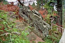
- Stimberg (156.9 m; with a striking sandstone rock formation and a former military radio tower) - north of (Klein-) Erkenschwick
- Rennberg (a good 138 m; with fire watch tower ) - south of Flaesheim
- Farnberg (136.4 m; with fire watch tower) - north-north-west of the Stimberg
- Küsberg (133.0 m) - extreme southeast, east of the Stimberg, in the area of the Rapen district
- Finkenberg (132.0 m) - south-southwest of Flaesheim
- Schlittenberg (127.4 m) - southern edge height, immediately north of Oer and within the district
- Weseler Berg (125.7 m) - roughly in the center of the Haard
- Schwarzer Berg (123.9 m) - north-northeast of Sinsen ( Marl )
- Dachsberg (122.6 m) - south of Flaesheim
- Scharpenberg (113.3 m) - northeast of Sinsen, immediately west of the Black Mountain
- Hammerberg (105.4 m) - south-southwest of Bossendorf
- Kibitzberg (104.0 m; until 2011 with fire watch tower ) - south of Bossendorf
- Eggenberg (77 m) - south-southeast of Bossendorf
geology
The Haard was formed during the Ice Age ; For more information, see Hohe Mark Nature Park .
At Stimberg there are rock banks made of sand, where a mixture of silica and colored iron compounds led to cementation , so that it became what is known as slab sandstone . The iron sandstones contain up to 30% iron.
In the valley that borders the Haard to the north, the Lippe flows westwards along the Wesel-Datteln Canal . The Haltern Reservoir and the Hullern Reservoir, through which the Lippe tributary Stever flows, are also located there .
Economy and Infrastructure
Infrastructure
The completely forested Haard is next to the neighboring Hohen Mark the largest contiguous forest area on the northern edge of the Ruhr area, which outside of the settlement otherwise consists of fields, meadows and also moors.
The Haard is almost uninhabited. There is only the specialist clinic for child and adolescent psychiatry of the Westphalia-Lippe Regional Association , the LWL Clinic Marl-Sinsen (Haardklinik) in Sinsen (Marl), two weather shafts from Deutsche Steinkohle AG , a sand extraction company ( Baggersee ), a forestry yard and several restaurants .
traffic
The federal motorway 43 leads through the western outlet of the Haard from Haltern am See in the north past Marl to Recklinghausen in the south . At the local cross Marl-Nord motorway crosses the interlocking on the cross over previous roads A52 and State Road 612. The latter runs along the northwestern edge of the Höhenzugs to L 551 in Bossendorf (holders) and then to the north passing L 609 at Flaesheim. Within the Haard runs between Bossendorf and Sinsen (Marl) on the L 798 in a north-south direction, the L 551, where the Haardklinik is located. The L 889 runs through the south-east outlet between Ahsen (Datteln) on the L 609 and Oer ( Oer-Erkenschwick ) on the L 798 in a north-east-south-west direction; From this street, the Redder street branches off approximately in the middle between the two villages , which runs to the northwest, in the ridge, among other things to the Jammertal Resort (hotel). The L 798 leads from Oer southwest past the Haard to Sinsen, where it meets the L 551.
The Rhein-Haard-Express (RE 2) runs every hour from Münster main station to Düsseldorf main station ; to Duisburg Hbf , the connection with the RE 42 line to Mönchengladbach is compressed to a half-hourly rhythm. The closest station is the Marl-Sinsen train station .
The Haard has numerous hiking and riding trails .
Opportunities for viewing
One of the two Haard fire watch and observation towers is on the Rennberg, the other on the Farnberg. When the visibility is good , there is a panorama that stretches from the Teutoburg Forest to the Lower Rhine and from the Baumberge to the Bergisches Land and Sauerland .
- 360 ° spherical panorama from the fire watch tower on the Rennberg (slightly different position than on the right, with spire)
literature
- Bruno Oelmann, Rolf Sonderkamp: On crooked tours through the Haard. The Haard Guide . Klartext Verlag, Essen 2008 (2nd edition 2010), ISBN 978-3-89861-996-7 .
- Bruno Oelmann: My most beautiful hike. Chronicle of the Haardwald . Verlag Rudolf Winkelmann, Recklinghausen 2000, ISBN 3-921052-75-0 .
- Wanderlust association in Recklinghausen (ed.): Haardführer. From Recklinghausen through the castle and through the Haard . Verlag F. Werres, Recklinghausen, 2nd edition 1918.
Web links
- Wilhelm von Kürten: Geographical land survey: The natural spatial units on sheet 95/96 Kleve / Wesel. Federal Institute for Regional Studies, Bad Godesberg 1977. → Online map (PDF; 6.9 MB)
Individual evidence
- ↑ a b Topographical Information Management, Cologne District Government, Department GEObasis NRW ( Notes )
- ^ Emil Meynen , Josef Schmithüsen (editor): Handbook of the natural spatial structure of Germany . Federal Institute for Regional Studies, Remagen / Bad Godesberg 1953–1962 (9 deliveries in 8 books, updated map 1: 1,000,000 with main units 1960).
- ↑ Map services of the Federal Agency for Nature Conservation ( information ) - Map service "Protected areas" shows the boundaries of the main unit group ("natural areas") and the main units as well as municipal boundaries, the somewhat coarser map service "Landscapes" divides the natural areas even more finely.
- ^ Wilhelm von Kürten: Geographical land survey: The natural space units on sheet 95/96 Kleve / Wesel. Federal Institute for Regional Studies, Bad Godesberg 1977. → Online map (PDF; 6.9 MB)
- ↑ Bruno Oelmann: My most beautiful hiking trip. Chronik des Haardwaldes , 2000 (see section Literature ), p. 21.


